Download
1 / 32
320 likes | 408 Views
The contribution of HyspIRI measurements to improving the quality of satellite-derived Climate Data Records . Peter J Minnett Meteorology & Physical Oceanography Rosenstiel School of Marine and Atmospheric Science University of Miami Miami FL USA. Outline.

E N D
The contribution of HyspIRI measurements to improving the quality of satellite-derived Climate Data Records Peter J Minnett Meteorology & Physical Oceanography Rosenstiel School of Marine and Atmospheric Science University of Miami Miami FL USA
Outline • Scales of variability in the ocean • Potential of higher spatial resolution measurements • Current limitations on CDRs imposed by medium resolution data • Overcoming the combined geophysical and instrumental effects in CDRs
Turbulent Energy Cascade • Energy is input to the climate system on large spatial scales and “cascades” through a sequence of turbulent processes to microscales. • Satellite remote sensing offers a unique perspective of these processes: prime example is mesoscale oceanic variability. • “Big whorls have little whorls that feed on their velocity, and little whorls have smaller whorls and so on to viscosity.” - L.F. Richardson.
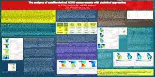
Scales of ocean variability Sub-mesoscale variability is not limited to shelf and estuarine processes. From Robinson, I. S. (2004), Measuring the Oceans from Space. The principles and methods of satellite oceanography, 515 pp., Springer Verlag - Praxis Publishing, Chichester, UK.
How is progress made? • In recent decades, progress in oceanic and atmospheric science has often followed the measurements of improved instrumentation: • Swallow floats & satellite images of oceanic mesoscale features. • Radars, aircraft and satellite measurements of cloud processes. • But now, modeling has moved beyond measurement capabilities.
High resolution simulations From below From above Domain dimensions: 25x25 km Blue: a density interface surface near the ocean surface Orange: buoyant plume Courtesy: Tamay Özgökmen, RSMAS - MPO
Simulations of ocean mixing Domain dimensions: 10x10 km A density interface surface intersecting the ocean surface. Courtesy: Tamay Özgökmen, RSMAS - MPO
Modeled SST – Florida Keys Grid size: 700m Courtesy: Dr Laurent Cherubin, RSMAS-MPO
Nested Modeled SST - Belize Nested grid resolutions: 2km → 690m → 230m Courtesy: Dr Laurent Cherubin, RSMAS-MPO
How to measure sub-mesoscale variability? • Ship-based: cannot provide synoptic sampling, even using multiple ships; traditional instruments are good for vertical sections, but not for horizontal. • Tracers: difficult to capture by ship tracking; airborne laser tracking is promising and under development. Overall, total tracer amount is too small and too short-lived to provide insight. • Gliders: these are in vogue, but expensive (so not too many), and have major post-processing challenges due to aliasing by time along the path. • Drifters: feasible, but need O(100) in a concentrated deployment, which is large enough to create environmental concerns. • HF radar: good, but limited to coastal zones. • High resolution satellite imagers (SARs, VIS, IR) – a very feasible option.
HyspIRI • Two instruments mounted on a satellite in Low Earth Orbit. • There is an imaging spectrometer measuring from the visible to short wave infrared (VSWIR) • multispectral thermal infrared (TIR) imager. • The VSWIR and TIR instruments will both have a spatial resolution of 60 m at nadir.
HyspIRI IR characteristics • IR Bands (8): • 3.98 µm, 7.35 µm, 8.28 µm, 8.63 µm, 9.07 µm, 10.53 µm,11.33 µm, 12.05 µm • IFOV: 60 m at nadir • Swath Width: 600 km • Cross Track Samples: 9,300 • Open Ocean: averaged to ~1 km spatial sampling
Satellite-derived CDRs • National Academy of Sciences Report (NRC, 2000): “a data set designed to enable study and assessment of long-term climate change, with ‘long-term’ meaning year-to-year and decade-to-decade change. Climate research often involves the detection of small changes against a background of intense, short-term variations.” • “Calibration and validation should be considered as a process that encompasses the entire system, from the sensor performance to the derivation of the data products. The process can be considered to consist of five steps: • instrument characterization, • sensor calibration, • calibration verification, • data quality assessment, and • data product validation.”
Desired SST CDR uncertainties • The useful application of all satellite-derived variables depends on a confident determination of uncertainties. • CDRs of SSTs require most stringent knowledge of the uncertainties: • Target accuracies: 0.1K over large areas, stability 0.04K/decade - Ohring et al. (2005) Satellite Instrument Calibration for Measuring Global Climate Change: Report of a Workshop. Bulletin of the American Meteorological Society 86:1303-1313
Sources of uncertainty in satellite-derived SSTs Many sources of retrieval algorithm errors (green box) and geophysical and model errors (orange box) are dependent on the spatial resolution of the satellite data.
SST retrievals: identifying clouds After Kilpatrick, K. A., G. P. Podestá, and R. H. Evans (2001), Overview of the NOAA/NASA Pathfinder algorithm for Sea Surface Temperature and associated Matchup Database, Journal of Geophysical Research, 106, 9179-9198.
SST retrievals: identifying clouds Many threshold values are scale dependent, and dependent on types of clouds present, and therefore dependent on time of day.
Why worry about sub-pixel variability? Mixture modeling of radiances should give sub-pixel information: From Robinson, I. S. (2004), Measuring the Oceans from Space. The principles and methods of satellite oceanography, 515 pp., Springer Verlag - Praxis Publishing, Chichester, UK.
Beware…… Failure to account for the MTF (Modulation Transfer Function) can lead to >10% errors in classifications
MTF of MODIS From Barnes, W. L., T. S. Pagano, and V. V. Salomonson (1998), Prelaunch characteristics of the moderate resolution imaging spectroradiometer (MODIS) on EOS-AM1, IEEE Transactions on Geoscience and Remote Sensing, 36, 1088-1110.
Pixel spatial response function • Instantaneous spatial responses of detectors are not uniform. • This compounds the MTF effect and increases errors in retrievals at the pixel scale. From Robinson, I. S. (2004), Measuring the Oceans from Space. The principles and methods of satellite oceanography, 515 pp., Springer Verlag - Praxis Publishing, Chichester, UK.
Summary • Natural variability covers a very wide range of scales, and is not truncated at the ~1km resolution of conventional oceanic and atmospheric imagers. • High-resolution HyspIRI data over the oceans will provide new insight into oceanic and atmospheric processes relevant to climate studies. • Many CDRs are derived from moderate-resolution data; high-resolution HyspIRI data can provide unique data with which to test, improve, and establish the limitations on accuracies imposed by sub-pixel variability. This would guide reprocessing algorithms to improve the accuracy of CDRs. • Improved CDRs provide a better basis for decision-makers to make hard choices… and to justify them.
One-liner…. Global HyspIRI mission can make a unique contribution to the climate monitoring and climate research communities.
One-liner…. Global HyspIRI mission can make a unique contribution to the climate monitoring and climate research communities.
Acknowledgements • Colleagues at RSMAS and elsewhere • Support from NASA PO program, Dr Eric Lindstrom