Download
1 / 10
120 likes | 347 Views
Rapid Post-Earthquake Information and Assessment Tools from the U.S. Geological Survey National Earthquake Information Center. USGS National Earthquake Information Center, Golden, Colorado. Paul Earle and David Wald. USGS National Earthquake Information Center.

E N D
Rapid Post-Earthquake Information and Assessment Tools from the U.S. Geological SurveyNational Earthquake Information Center USGS National Earthquake Information Center, Golden, Colorado Paul Earle and David Wald
USGS National Earthquake Information Center The NEIC has produced and distributed authoritative global and national earthquake locations for over 30 years. It is the only US seismic monitoring system federally-mandated to provide earthquake information for the Nation and the globe. The NEIC has direct contact with the White House, the State Department, US Agency of International Development (USAID), numerous foreign agencies, major media outlets, and over 60,000 individuals currently receive NEIC earthquake alerts. The NEIC recently implemented 24x7 in-house staffing. Seismologists are always available to review and update earthquake response products. As part of the Advanced National Seismic Network, the NEIC integrates and distributes data from multiple seismic networks. The NEIC generates a premier global earthquake bulletin of locations, magnitudes, and damage reports.
As part of the Advanced National Seismic Network (ANSS), the NEIC produces and distributes numerous products that provide situational awareness in the period immediately following significant earthquakes.See: http://earthquake.usgs.govhttp://pubs.usgs.gov/fs/2006/3050
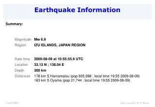
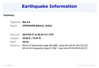
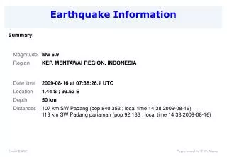
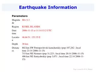
USGS Earthquake Websitehttp://earthquake.usgs.gov Within about 20 minutes of the occurrence of a significant global earthquake, the NEIC posts it location and magnitude on the USGS Earthquake Hazards Program website with supporting maps and contextual information.
Earthquake Notification Servicehttp://earthquake.usgs.gov/ens Earthquake alerts are automatically sent to wireless devices and e-mail accounts using the USGS Earthquake Notification Service. The user can specify a personalized geographic region and magnitude range for his/her alerts.
ShakeMaphttp://earthquake.usgs.gov/shakemap Pakistan Oct 8th, 2005 For significant earthquakes worldwide, predicted maps of ground shaking (ShakeMaps) are generated shortly after the determination of location and magnitude. These maps provide an indication of where damage is likely concentrated and are updated as more information becomes available.
ShakeCasthttp://earthquake.usgs.gov/resources/software/shakecastShakeCasthttp://earthquake.usgs.gov/resources/software/shakecast ShakMaps are distributed to users by several methods and in many formats. They can be downloaded from the Internet, obtained from an RSS feed, and automatically delivered using a client-side application called ShakeCast. ShakeCast was developed for critical lifeline operators. The software runs on the users computer and automatically downloads recent ShakeMaps. The ShakeMaps are compared to a user entered inventory and a list of likely damaged structures is generated and notification alerts are distributed if necessary.
Did You Feel It?http://earthquake.usgs.gov/dyfi Pakistan Oct 8th, 2005 In addition to the instrumentally and theoretically derived ShakeMaps, the shaking distribution is mapped from observations submitted to the USGS website from citizens who experienced the shaking. These observations provide an indication of where damage is likely concentrated and provide important constraints to USGS ShakeMaps in regions without seismic instrumentation.
Prompt Assessment Of Global Earthquakes for Response http://earthquake.usgs.gov/pager The USGS is developing a system to rapidly and automatically estimate the probable societal impact of significant global earthquakes. The current PAGER system estimates the population exposed to significant ground shaking. PAGER results will be available through the USGS website later this year. The current research focus is on developing and implementing a loss estimation methodology and improving our rapid estimation of ground motion. Pakistan Oct 8th, 2005
USGS earthquake response products • Supporting maps and overview (main web pages) • earthquake.usgs.gov • Customizable earthquake notification (ENS) • earthquake.usgs.gov/ens • Maps of ground shaking (ShakeMap) • earthquake.usgs.gov/shakemap • Automated delivery and processing of ShakeMaps • earthquake.usgs.gov/shakecast • Summary of observed ground shaking (DYFI?) • earthquake.usgs.gov/dyfi • Impact assessment (PAGER) • earthquake.usgs.gov/pager