Download
1 / 60
630 likes | 677 Views
Learn about hydraulic routing to improve flood prediction accuracy using theoretical background, software models, and recommendations for flood routing models and predictions.

E N D
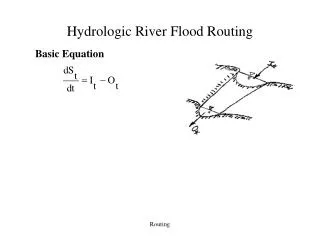
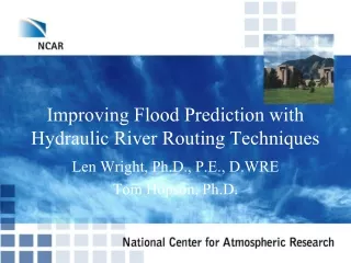
Improving Flood Prediction with Hydraulic River Routing Techniques Len Wright, Ph.D., P.E., D.WRE Tom Hopson, Ph.D.
Outline • Benefits of hydraulic routing to improve accuracy of flood prediction • Theoretical background • Software model survey • Recommendations
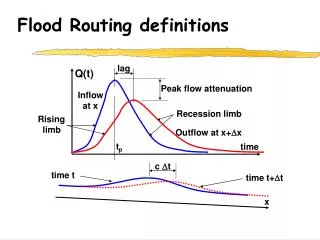
Reasons for a Flood Routing Model • To extend usefulness of any rainfall/runoff estimate (i.e. historical, future scenario, near-term prediction) • Estimate timing, attenuation and height of peak flood levels • Accurate addition of hydrographs at confluences – the problem of coincident peaks vs. off-setting peaks
Ancillary Reasons for Models Estimating the impacts of change resulting from planned, or unplanned, future conditions Evaluating engineering decisions on planning, design and operation of structural and non structural flood mitigation strategies Water quality and sediment transport modeling
Problems with Attempting to Predict Flood Levels • Difficult technical questions to be answered: • WHEN: How long after the rain will the flood arrive? • HOW MUCH? Magnitude of the flow? How deep will it be? • Answer is a complex physical interaction between watershed hydrology, channel geometry and network topology: • Watershed response to precipitation: hydrology • Watershed and channel geometry • River network topology: tributary connectivity afftects watershed response and subsequent downstream flooding
Theoretical Background • River flow – assumed one-dimensional • Two-dimensional models available for estuaries (provides downstream boundary) • Governing equations – St. Venant • Data requirements – channel and flood plain geometry, roughness, upstream spatial and temporal boundary, downstream boundary (for subcritical flow)
Conservation of mass, energy and momentum May be derived from full “Navier-Stokes” equations Continuity and Energy: Coupled pair of hyperbolic partial differential equations No closed-solution (except for simple cases), variety of numerical solutions exist. Governing Equations“St. Venant’s”
St. Venant Equations Conservation of Mass Conservation of Momentum Steady, uniform Steady, nonuniform Unsteady, non-uniform
Effect of Storage in River • Important for flood routing – wedge routing provides opportunity for wave attenuation • Non-uniform unsteady flow affects rating curve – flow is not a one-to-one relationship with depth
Wedge Storage Effects on Real Flood Hydrographs • Dashed line rating curve shows results of uniform flow assumption • Loop is result of acceleration on leading edge of flood hydrograph and decceleration on the falling edge
Internal Watershed Features • Man-made drainage improvements affect the way a watershed responds to precipitation – should be accounted for.
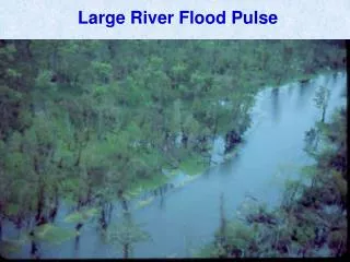
Hydraulic Floodplain Impacts • Storage and routing on floodplain is critical to accurate prediction of attenuation and timing of flood peak. • Results show spatial extent of innundation.
Floodplain Structures • Structures and features in the floodplain must be correctly represented. • Note landfill and levee in this floodplain.
Data Requirements • High quality cross section data – elevation versus distance • Roughness • Longitudinal channel distance • Over bank detail – roughness and curvature • Structures – bridges, dams, levees, etc
Partial Model Survey • HEC-RAS: US Army Corp of Engineers Hydrologic Engineering Center River Analysis System • SWMM: US EPA Stormwater Management Model • FLDWAV: US National Weather Service • Mike-11: Danish Hydraulic Institute
HEC-RAS • Both steady state and unsteady solutions available • Widely used in the US for floodplain management studies • Free • Good capability of simulating structures and for doing sensitivity and “waht-if” analyses.
USEPA SWMM 5 • Includes rainfall runoff processes as well as routing • Full Dynamic Wave routing • Structures and control available • Designed for urban environmental model • Long-term continuous simulation supported
US EPA SWMM • Key strength: simulation of surcharged pipes and culverts • Performs hydrologic and hydraulic simulation • Continuous, long-term simulation or event-based
NWS FLDWAV • Good for areas of low-quality or non-existent data • Precedence in flood warning systems in North America
DHI MIKE-11 • Sophisticated, state of the art modeling environment • Dynamic wave, handles many types of hydraulic structures and control rules • Licenses are relatively expensive
MIKE 11 PRODUCT HOME RAINFALL-RUNOFF WATER QUALITY MIKE 11 is a professional engineering software package for modelling of rivers, reservoirs, flood plains and canal systems • It is used for simulation of: • Hydrodynamics • Water quality & ecology • Sediment transport
KEY APPLICATION AREAS flood analysis and mapping design of flood alleviation systems dam break analysis real-time flood, inflow and WQ forecasting analysis and design of hydraulic structures drainage and irrigation studies optimization of river and reservoir operations water quality issues integrated groundwater/surface water analysis
FLOODING & HYDRAULICS SIMULATION OPTIONS • Flow routing (Muskingum, linear reservoir) • Steady state • Hydrodynamic modeling • Stratified flow • Combined 1-D and 2-D simulation
MIKE 11- FEATURES Hydraulics and structures 1-dimensional model Rainfall-runoff Sediment and water quality Flooding DHI product integration Forecasting
A MODULAR STRUCTURE Rainfall-Runoff Hydrodynamics Flood Forecasting Sediment Transport Advection-Dispersion • Databases • Topographical Data • Time Series Data Water Quality Modules and Databases that Interact Dynamically
MIKE 11 GIS MIKE 11 GIS is an ArcGIS desktop extension for: • facilitating model setup and river network editing in MIKE 11 • pollutant load estimations from non-point sources, and • time series data analysis
RIVER NETWORK EDITING IN GIS Generate Cross-section lines Auto generate based on desired distances and river width Import surveyed lines Extend existing X-sec lines onto flood plain Generate Actual cross-sections Extract from DEM Import surveyed data View/edit in cross-section editor
PSEUDO 2D FLOODPLAIN MAPPING City of Canberra, Australia
RAINFALL-RUNOFF MODELLING IN MIKE 11 Rainfall – Runoff modelling is the process of transforming rainfall into catchment runoff Runoff in MIKE 11 includes all the lateral inflow from the small streams not represented in MIKE 11 • Catchment yield estimation is important in water resources operation, management and planning • Forecasting floods/droughts • Reservoir inflow • Water resources management • … and many other applications
MIKE 11 - DISTRIBUTED RAINFALL-RUNOFF MODELLING Distributed, physically based where we have detailed info e.g. climate, vegetation and soils …while maintaining lumped, conceptual approach where we lack data e.g. groundwater Dynamically coupled to MIKE 11 Auto-calibration (AutoCal)
RESERVOIR OPTIMISATION It may be worth spending time & money to investigate how reservoir operation can be improved Small changes can make large difference in earnings and welfare
THE SIMULATION-OPTIMISATION FRAMEWORK Optimize Flood potential / risk Water deficits (hydropower, irrigation etc.) Water quality conditions Control variables • MIKE BASIN • MIKE 11 • MIKE SHE AUTOCAL Simulation model Optimisation algorithm Model output Objective functions Optimisation targets
MIKE 11 – STRUCTURES & DAMBREAK t = t1 t = t2 t = t3 Simulation of the flow through a dam breach defined as: 1) Predefined in time 2) Calculated using sediment transport formula. • HydraulicStructures • Weirs • Culverts • Bridges • Regulation • Control Structures • Dambreak Failures
Model Selection • Model selection is a very important step in the process. Fully examine all the possible uses the model could be used for. • Collaborative efforts across agencies and organizations may provide greater room for greater project resources. • Model should be selected that best handles all purposes (flood warning, water quality, sediment transport, planning and engineering)
Recommendations • Data requirements are an important consideration – do project resources warrant a high-level of sophisticated data? • For flooding: time-scale of warnings required • Economics of data collection should be considered in this evaluation, as is software cost • Will the model be used for engineering decision making? If so, HEC-RAS and MIKE-11 (expensive) are better suited for these purposes than FLDWAV. SWMM is better at pipe network simulation if that is important anywhere.
Ancillary Issues Are there other analyses (besides flood warning) that the model could be used? If so include these benefits when making a model selection Model selection is long-term decision Will “What-IF?” analyses be needed? The ability of the model to handle the important scenarios should be evaluated (ie real-time control, structural improvements, etc). Will continuous simulation be used to evaluate sediment transport (e.g. bridge scour)? This will impact the model selection process.