Download
1 / 29
290 likes | 434 Views
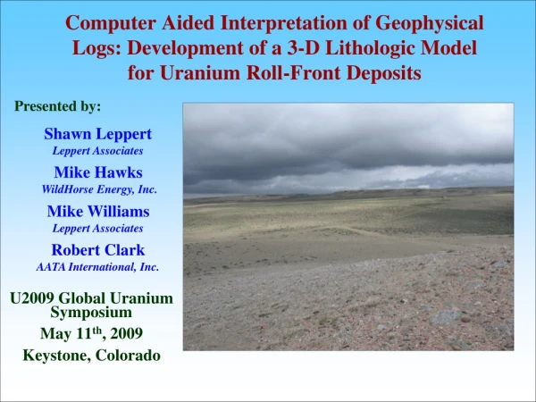
Computer Aided Interpretation of Geophysical Logs: Development of a 3-D Lithologic Model for Uranium Roll-Front Deposits. Presented by:. Shawn Leppert Leppert Associates. Mike Hawks WildHorse Energy, Inc. U2009 Global Uranium Symposium May 11 th , 2009 Keystone, Colorado. Mike Williams

E N D
Computer Aided Interpretation of Geophysical Logs: Development of a 3-D Lithologic Model for Uranium Roll-Front Deposits Presented by: Shawn Leppert Leppert Associates Mike Hawks WildHorse Energy, Inc. U2009 Global Uranium Symposium May 11th, 2009 Keystone, Colorado Mike Williams Leppert Associates Robert Clark AATA International, Inc.
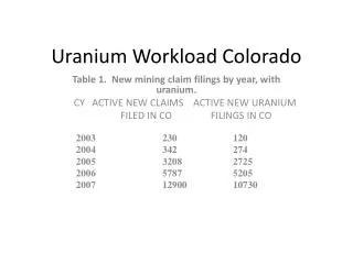
Geophysics to Hydrostratigraphy • In the Current U.S Regulatory Environment - To Obtain a Permit for the Development of a Uranium In-Situ Recovery (ISR) Mine - Groundwater Flow must be Thoroughly Understood. • In the Current U.S Economic Environment - Mine Operations must be Optimized to Maximize the Mass of Uranium Ore Recovered with Respect to the Energy and Expense Required to Achieve that Recovery (Lixiviant Delivery and Fluid Recovery). • One Approach to Meeting these Two Requirements is to Develop a Detailed Hydrogeologic Conceptual Model to Assist in the Decision Making Process. • Many Uranium Roll-Front Ore Bodies are Found in Relatively Complex Hydrogeologic Environments • Cost of Hydrologic Characterization in Complex Subsurface Environment can be Expensive. • A Means for Reducing Those Costs is to Extract as Much Information as Possible from Existing Data - One Source of Data are Historical Geophysical Logs.
Data Evaluation Decision Pilot Tests & Additional Characterization Hydraulic Property Estimation Well Construction Tables (static) Geochemical Table (Static) Event Tables (dynamic) GW Quality Tables (dynamic) Hydrostratigraphy Tables (static) Hydrologic Tables (dynamic) Quantitative Model Electronic Database Lixiviant Delivery & Recovery System Design System Performance Monitoring Reclamation Quantitative Hydrogeologic Decision Framework Geology Hydrology Geochemistry Geophysical Reports/Permits
Geology to Hydrostratigraphy • Targeted Uranium Deposits are Located in Fremont County, Wyoming • Preeminent Geologic Conceptual Model for the Area Developed by the USGS • Geologic Map and Sections Showing Areal Distribution of Tertiary Rocks Near the Southeastern Terminus of the Wind River Range, Fremont and Sweetwater Counties, Wyoming (N.M. Denson and G.N. Pipiringos. 1974)
Geology to Hydrostratigraphy • Targeted Uranium Claim Site Claim Site
Geology to Hydrostratigraphy • Targeted Uranium Claim Site • Primary Groundwater-Bearing Units of Interest: Arikaree Formation (Ta; Lower Miocene) Bridger Formation (Tbr; Upper Eocene) Green River Formation – Both Upper & Lower Laney Members (Tgul, Tgll; Lower Eocene) Battle Springs Formation (Tbr; Lower Eocene)
Geology to Hydrostratigraphy • Targeted Uranium Claim Site • Primary Groundwater-Bearing Units of Interest: • Geologic Structure May be a Very Important Control on the Movement of Groundwater U • Structure Contours for Arikaree Formation D U Flattop Fault D Horse Track Anticline D U U • Horse Track Anticline D U D D • Numerous Normal Faults U
Geology to Hydrostratigraphy • Targeted Uranium Claim Site • Primary Groundwater-Bearing Units of Interest: • Geologic Structure May be a Very Important Control on the Movement of Groundwater • Define the Groundwater Basin Which the Targeted ISL Mine Would be Located
Geology to Hydrostratigraphy • Targeted Uranium Claim Site • Primary Groundwater-Bearing Units of Interest: • Geologic Structure May be a Very Important Control on the Movement of Groundwater • Define the Groundwater Basin Which the Targeted ISL Mine Would be Located
Geology to Hydrostratigraphy • Targeted Uranium Claim Site • Primary Groundwater-Bearing Units of Interest: • Geologic Structure May be a Very Important Control on the Movement of Groundwater • Define the Groundwater Basin Which the Targeted ISL Mine Would be Located
Geology to Hydrostratigraphy • Targeted Uranium Claim Site • Primary Groundwater-Bearing Units of Interest: • Geologic Structure May be a Very Important Control on the Movement of Groundwater • Define the Groundwater Basin Which the Targeted ISL Mine Would be Located
Geophysical Data - Hydrostratigraphy • Geophysical Data are Routinely Collected for Uranium Exploration Borings • Often there are Significant Quantities of Historical Data as Well as New Exploration Data • Uranium Exploration in 1950’s, 1960’s and 1970’s • 4 Common Historical Types of Data Acquired • Gamma Logs * • Single Point Resistance Logs ** • SP Logs • Neutron Logs • Single Point Resistance Logs have Potential for Delineating Relative Lithology • Measures the Electical Resistance Between an Electrode Placed at the Surface and a one placed within a Boring
Geophysical Data - Hydrostratigraphy Signal Analysis Tool Calibration Interpretation Data Develop a Signal Analysis Tool which has both Flexibility and Calibration Capabilities Calibrate the Signal Analysis by Leveraging Experienced Geologists Interpretation Evaluate Uncertainties and Limitations of Site Data All Information has been Extracted from Data for the Hydrostratigraphic Model Digitized Geophysical Logs Major Geologic Unit Picks Boring Locations Signal Analysis Reproduces Geologist’s Interpretation Develop Local Hydrostratigraphy Model from Signal Analysis and Perform Additional Checks Adjustments Required
Geophysical Data • Geophysical Data • Boring Data • Nearly 1000 Borings • Surveyed Coordinates • Surveyed Ground Surface Elevation • Geophysical Logging Data • Data Compiled into a Relational Database.
Geophysical Data • Geophysical Data • Boring Data • Digitize Logs • Digitize to 2.0 foot Precision - Capture Peaks and Troughs • Scaled • Data Compiled into a Relational Database
Geophysical Data • Geophysical Data • Boring Data • Digitize Logs • Geologic Units • Geologist Evaluated each Available Geophysical Log and Picked the Likely Geologic Unit Contacts • Geologic Unit Picks were Integrated into the Groundwater Basin Scale Hydrostratigraphic Conceptual Model • Data Compiled into a Relational Database
Signal Analysis Tool Development • Geophysical Data • Boring Data • Digitize Logs • Geologic Units • Signal Analysis Tool Development • Smooth Noise • Signals Can be Quite Noisy • For each point, pick the N points on either side value to be average of all 2N+1 points • Repeat Smoothing Algorithm as Appropriate • Depends on Calibration
Signal Analysis Tool Development • Geophysical Data • Boring Data • Digitize Logs • Geologic Units • Signal Analysis Tool Development • Smooth Noise • Filter Drift • Wireline Tool Signal can Drift as it is getting Lowered in the Boring • Ignore Peaks and Troughs • Linear Regression Analysis • Adjust Smoothed Signal Based on Regression
Signal Analysis Tool Development • Geophysical Data • Boring Data • Digitize Logs • Geologic Units • Signal Analysis Tool Development • Smooth Noise • Filter Drift • Peaks/Troughs • Use a Five Point Estimate of the First Derivative • Slope of the Signal
Signal Analysis Tool Development • Geophysical Data • Boring Data • Digitize Logs • Geologic Units • Signal Analysis Tool Development • Smooth Noise • Filter Drift Minor Peaks can be Removed • Peaks/Troughs • Trivial Peaks • If a Signal Peak is Relatively Small Eliminate from Consideration • Depends on Calibration with Geologist Picks
Signal Analysis Tool Development • Geophysical Data • Boring Data • Digitize Logs • Geologic Units Group Peaks from the Same Signal Response • Signal Analysis Tool Development • Smooth Noise • Filter Drift • Peaks/Troughs • Trivial Peaks • Group Peaks • Group Peaks from the Same Signal Response
Signal Analysis Tool Development • Geophysical Data • Boring Data • Digitize Logs • Geologic Units • Signal Analysis Tool Development • Smooth Noise • Filter Drift • Peaks/Troughs • Trivial Peaks • Group Peaks • Peak Width • Use a Five Point Estimate of the Second Derivative • Slope of the Slope of the Signal • Geologist Picks are not this Mechanical
Signal Analysis Tool Development • Geophysical Data • Boring Data • Digitize Logs • Geologic Units • Signal Analysis Tool Development • Smooth Noise • Filter Drift • Peaks/Troughs • Trivial Peaks Sandstone • Group Peaks • Peak Width Silty Sandstone • Peak Magnitude • Correlate Peak Magnitude with Lithologic Material Claystone • Claystone/Siltstone • Silty Sandstone • Sandstone
Signal Analysis Calibration • Geophysical Data • Boring Data • Digitize Logs • Geologic Units • Signal Analysis Tool Development • Smooth Noise • Filter Drift • Peaks/Troughs • Trivial Peaks • Group Peaks • Peak Width • Peak Magnitude • Calibration • Geologist Picks • Experienced Geologists Examined 18 Diagnostic logs and Made Picks • Used for Calibration
Signal Analysis Calibration • Geophysical Data • Boring Data • Digitize Logs • Geologic Units • Signal Analysis Tool Development • Smooth Noise • Filter Drift • Peaks/Troughs • Trivial Peaks • Group Peaks • Peak Width • Peak Magnitude • Calibration • Geologist Picks • Experienced Geologists Examined 18 Diagnostic logs and Made Picks • Used for Calibration
Geophysical Data - Hydrostratigraphy • Geophysical Data • Boring Data • Digitize Logs • Geologic Units • Signal Analysis Tool Development • Smooth Noise Lithology within Boring • Filter Drift • Peaks/Troughs • Trivial Peaks • Group Peaks • Peak Width • Peak Magnitude • Calibration • Geologist Pics • Results
Geophysical Data - Hydrostratigraphy • Geophysical Data • Boring Data • Digitize Logs • Geologic Units • Signal Analysis Tool Development • Smooth Noise • Filter Drift • Peaks/Troughs • Trivial Peaks • Group Peaks • Peak Width • Peak Magnitude • Calibration • Geologist Pics • Results
Conclusions • There can be a Wealth of Valuable Hydrogeologic Information Buried in Historical Geophysical Logs. • Using Relatively Simple Signal Analysis Techniques, this Information can be Cost-Effectively Extracted. • These Data can be Incorporated into a Hydrogeologic Model to Enhance our Understanding of the Hydrology within an Mine Site and Assist in Effective ISR of Uranium Ore.