1 / 16

东南亚

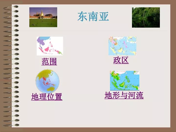
东南亚. 政区. 范围. 地形与河流. 地理位置. 中. 南. 半. 岛. 马. 来. 半. 岛. 东南亚范围. 中 国. 南 海. 马  来  群  岛. 文莱. 缅. 越. 老. 甸. 泰. 挝. 国. 南. 马. 来. 亚. 西. 西. 亚. 来. 马. 东南亚政区. 中 国. 柬埔寨. 菲律宾. 新加坡. 印   度   尼   西   亚. 东南亚政区. 在图中依次找出各国的首都. 东南亚在地球上的位置. 马. 六. 甲. 海. 峡. 亚洲. 北回归线( 23.5 ° N ).

goldy
Download Presentation

东南亚

An Image/Link below is provided (as is) to download presentation Download Policy: Content on the Website is provided to you AS IS for your information and personal use and may not be sold / licensed / shared on other websites without getting consent from its author. Content is provided to you AS IS for your information and personal use only. Download presentation by click this link. While downloading, if for some reason you are not able to download a presentation, the publisher may have deleted the file from their server. During download, if you can't get a presentation, the file might be deleted by the publisher.

E N D

Presentation Transcript


  1. 东南亚 政区 范围 地形与河流 地理位置

  2. 南 半 岛 马 来 半 岛 东南亚范围 中 国 南 海 马  来  群  岛

  3. 文莱 缅 越 老 甸 泰 挝 国 南 马 来 亚 西 西 亚 来 马 东南亚政区 中 国 柬埔寨 菲律宾 新加坡 印   度   尼   西   亚

  4. 东南亚政区 在图中依次找出各国的首都

  5. 东南亚在地球上的位置

  6. 六 甲 海 峡 亚洲 北回归线(23.5°N) 太 平 洋 马 来 苏门答腊岛 半 印 度 洋 岛 赤道(0°) 大洋洲 10°S 东南亚地理位置 纬度位置 海陆位置

  7. 马六甲海峡航线图

  8. 洛 瓦 萨 底 尔 红 河 江 温 湄 江 湄南河 公 河 东南亚地形和河流 红河   湄公河 湄南河  萨尔温江  伊洛瓦底江

  9. 湄公河 湄公河上下游地形剖面图 湄公河三角洲示意图

  10. 湄公河景观 繁忙的湄公河 湄公河畔的水上村庄

  11. 湄公河景观 湄公河三角洲

  12. 中南半岛:山河相间,南北纵列 东南亚地形 马来群岛:多火山

  13. 东南亚 世界火山地震带

  14. 马来群岛的火山 菲律宾的火山

  15. 马来群岛的火山 菲律宾的马荣火山

  16. 火山下的农业生产 菲律宾梯田 印度尼西亚火山下的梯田

More Related