Download
1 / 4
40 likes | 130 Views
Session 1. Needs from BoM services - Kevin Parkyn Moisture not well captured in current models. Ground moisture and mixing depth taken into account by forecasters.

E N D
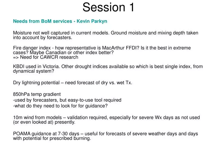
Session 1 Needs from BoM services - Kevin Parkyn Moisture not well captured in current models. Ground moisture and mixing depth taken into account by forecasters. Fire danger index - how representative is MacArthur FFDI? Is it the best in extreme cases? Maybe Canadian or other index better?=> Need for CAWCR researchKBDI used in Victoria. Other drought indices available so which is best single index, from dynamical system? Dry lightning potential – need forecast of dry vs. wet Tx. 850hPa temp gradient • used by forecasters, but easy-to-use tool required • what do they need to look for for guidance? 10m wind from models – validation required, especially for severe Wx days as not used (or even looked at) presently. POAMA guidance at 7-30 days – useful for forecasts of severe weather days and days with potential for prescribed burning.
Needs from BoM services - Kevin Parkyn, cont. Google Earth (or any GIS based system) would be very useful as platform for maps, e.g. fire spread, IR imagery • in conjunction with GFE Extreme fire days warning category – not just FDI > 100. More research needed Plume height – research needed to understand fire behaviour in models. • comparison between wind-driven fires and those with significant plumes • no clear conceptual model for forecasters, not part of GFE Wind change – consistent product required, within GFE. Needs to interact with latest data, overlay fields. Verification of GFE forecasts - fire agencies need convincing of accuracy - review performance for 2008/9 fire season. Prescribed burning guidance – requirements vary with region Curing – what will come out of Bushfire CRC research. Overlay in GFE in gridded format Radar – what can be used operationally? - will plumes seen impact on operational decisions
GA perspective – Bob Cechet Risk assessment and evaluation Impacts of events on people and infrastructure Why do some houses survive but not others? Inform government – scenario building • planning for emergency services to help decision making • how different events impact infrastructure Fire risk now and under climate change • how might potential for disastrous fires change • long term infrastructure planning Require better database of previous events – event modelling for risk assessment Modelling relationship between FFDI and house loss, forecasting impacts Human behaviour and how it relates to house loss How will risk evolve under climate change? Model impacts of wide range of events at many locations Need to bring together different research to have overall picture of braodscale risk
GFE – John Bally GFE includes curing product – will be able to include elevation variations, soil type, recent rain – satellite data? Very basic DI used – no aspect, slope, soil type, etc. Ensemble prediction products – probabilistic forecasts, range of possible scenarios, confidence in forecasts OCF initialisation – improvements needed for dew point and wind data Downscaling needs to be better • currently many models with different resolutions, land surfaces • wind a particular concern • in some cases only one model should be used, or no downscaling at all • agencies are asking for hi-res data • major research needed to understand potential and develop better techniques Indices – insolation needs to be included • how are they for extreme events? • need there to incorporate best current research • build in slope, aspect, etc. • collaboration needed with other agencies • nowcasting with satellite data (radar?) to produce rapid response services • forecasting prescribed burning opportunites Fuel state data outdated – needs improving. Should this be done within or outside of GFE? Research should have GFE and service delivery in mind from the outset