Download
1 / 38
380 likes | 408 Views
Explore the scientific revolution of plate tectonics from Wegener's pioneering ideas to modern seafloor mapping and geomagnetic reversals. Unveil the concept of Earth's tectonic plates and their interactions, shaping our world.

E N D
Alfred Wegener • first proposed continental drift hypothesis in 1915 • published The Origin of Continents and Oceans • Continental drift hypothesis • the supercontinent called Pangaea began breaking apart about 200 million years ago Continental Drift: An Idea Before Its Time
Continental drift hypothesis • continents "drifted" to present positions • Evidence used in support of continental drift hypothesis: • fit of the continents • fossil evidence • rock type and structural similarities • paleoclimatic evidence Continental Drift: An Idea Before Its Time
Objections to the continental drift hypothesis: • lack of a mechanism for moving continents • Wegener incorrectly suggested that continents broke through the ocean crust • strong opposition to the hypothesis from all areas of the scientific community • In Alfred Wegener’s Honour • The Amoeba People The Great Debate
Continental drift and the scientific method • Wegener’s hypothesis was correct in principle, but contained incorrect details • a few scientists considered Wegener’s ideas plausible and continued the search The Great Debate…
A renewed interest in continental drift initially came from rock magnetism • Magnetized minerals in rocks: • show the direction to Earth’s magnetic poles • provide a means of determining their latitude of origin Continental Drift and Paleo-magnetism
Polar wandering • the apparent movement of the magnetic poles indicates that the continents have moved • it also indicates Europe was much closer to the equator when coal-producing swamps existed • curves for North America and Europe have similar paths but are separated by about 24 degrees of longitude • differences between the paths can be reconciled if the continents are placed next to one another
During the 1950s and 1960s, technological strides permitted extensive mapping of the ocean floor • Theseafloor spreading hypothesiswas proposed by Harry Hess in the early 1960s • new oceanic crust is formed through volcanic activity and then gradually moves away from the ridge A Scientific Revolution Begins
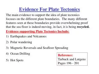
Geomagnetic reversals • Earth's magnetic field periodically reverses polarity—the north pole becomes the south pole, and vice versa • dates when the polarity of Earth’s magnetism changed were determined from lava flows • geomagnetic reversals are recorded in the oceanic crust • in 1963, Vine and Matthews tied the discovery of magnetic stripes in the oceanic crust near ridges to Hess’s concept of seafloor spreading • paleo-magnetism was the most convincing evidence set forth to support the concepts of continental drift and seafloor spreading
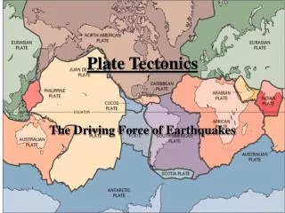
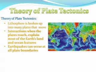
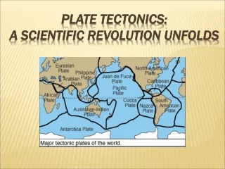
Earth’s major plates • associated with Earth's strong, rigid outer layer: • known as the lithosphere • consists of uppermost mantle and overlying crust • overlies a weaker region in the mantle called the asthenosphere Plate Tectonics: The New Paradigm
seven major lithospheric plates • plates are in motion and are continually changing in shape and size • the largest plate is the Pacific plate • several plates include an entire continent plus a large area of seafloor • plates move relative to each other at a very slow but continuous rate • about five (5) centimeters (two (2) inches) per year • cooler, denser slabs of oceanic lithosphere descend into the mantle
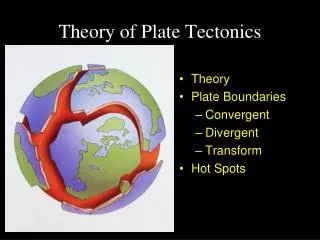
Plate boundaries • interactions among individual plates occur along their boundaries • types of plate boundaries: • divergent plate boundaries • (constructive margins) • convergent plate boundaries • (destructive margins) • transform fault boundaries • (conservative margins) • each plate is bounded by a combination of the three types of boundaries • new plate boundaries can be created in response to changing forces
Most are located along the crests of oceanic ridges • oceanic ridges and seafloor spreading • along well-developed divergent plate boundaries, the seafloor is elevated, forming oceanic ridges • seafloor spreading occurs along the oceanic ridge system • Spreading rates and ridge topography • ridge systems exhibit topographic differences • differences are controlled by spreading rates Divergent Plate Boundaries
Continental rifting • Splits landmasses into two or more smaller segments along the continental rift • Examples include: • East African Rift Valleys • Rhine Valley Northern Europe
Older portions of oceanic plates are returned to the mantle at these destructive plate margins • surface expression of the descending plate is an ocean trench • also called subduction zones • average angle of subduction = 45° Convergent Plate Boundaries
Types of convergent boundaries: • oceanic–continental convergence • the denser oceanic slab sinks into the asthenosphere • along the descending plate, partial melting of mantle rock generates magma • the resulting volcanic mountain chain is called a continental volcanic arc • the Andes and the Cascades are examples Convergent Plate Boundaries
Oceanic–oceanic convergence • when two oceanic slabs converge, one descends beneath the other • often forms volcanoes on the ocean floor • if the volcanoes emerge as islands, a volcanic island arc is formed • Japan, the Aleutian islands and the Tonga islands are examples Convergent Plate Boundaries
Continental–continental convergence • continued subduction can bring two continents together • less dense, buoyant continental lithosphere does not subduct • the resulting collisionproduces mountains • the Himalayas, the Alps and the Appalachians are examples
Continental–Continental Convergence
Plates slide past one another and no new lithosphere is created or destroyed • Transform faults • most join two segments of a mid-ocean ridge along breaks in the oceanic crust known as fracture zones • a few (the San Andreas Fault and the Alpine Fault of New Zealand) cut through continental crust Transform Fault Boundaries
Evidence from ocean drilling • some of the most convincing evidence has come from drilling directly into ocean-floor sediment • age of deepest sediments • the thickness of ocean-floor sediments verifies seafloor spreading Testing the Plate Tectonics Model
Hot spots and mantle plumes • caused by rising plumes of mantle material • volcanoes can form over them (Hawaiian Island chain) • mantle plumes • long-lived structures • some originate at great depth Testing the Plate Tectonics Model
Paleo-magnetism and plate motions • paleo-magnetism stored in rocks on the ocean floor provides a method for determining plate motions • both the direction and the rate of spreading can be established Measuring Plate Motion
Measuring plate velocities from space • accomplished by establishing exact locations on opposite sides of a plate boundary and measuring relative motions • various methods are used: • Global Positioning System (GPS) Measuring Plate Motion
Researchers agree that convective flow in the mantle is the basic driving force of plate tectonics • Forces that drive plate motion: • slab-pull • ridge push • Models of plate–mantle convection • model must be consistent with observed physical and chemical properties of the mantle • layering at 660 kilometers • whole-mantle convection What Drives Plate Motions?
The theory provides explanations for: • Earth’s major surface processes • distribution of earthquakes, volcanoes, and mountains • distribution of ancient organisms and mineral deposits • may someday be used for prediction Importance of Plate Tectonics