Download
1 / 17
170 likes | 176 Views
This research presents a preliminary statistical comparison between Brazilian census data (regions, states, and counties) and SPOT VGT land-cover mapping based on a subset for the Brazilian southern region. The study aims to assess the correlation between census data and VGT land-cover classification, focusing on agriculture, pastures, and forest remnants in agricultural areas. The results show valuable insights for 40% of Brazil, highlighting the correlation between crops and pastures and suggesting further detailed comparisons at the county level.

E N D
A Comparison Between GLC2000 Results and Brazilian Census Data Evaristo Eduardo de Miranda Marcelo Guimarães Eliane Gonçalves Gomes Alejandro Jorge Dorado
5 REGIONS • 27 STATES • 5,500 COUNTIES
MAP LEGEND 24 CLASSES
RESEARCH GOAL • A PRELIMINARY STATISTICAL COMPARISON BETWEEN CENSUS DATA (REGIONS, STATES, AND COUNTIES) AND SPOT VGT LAND-COVER MAPPING
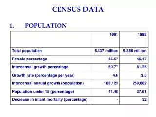
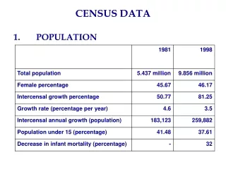
BRAZILIAN CENSUS • TEN YEAR BASIS SINCE 1870 (YEAR 2000) • ONLY RURAL AREAS, BUT ALL FARMS • ESTIMATIVES BASED ON FARMERS DECLARATIONS • HOMOGENEOUS METHODOLOGY • CLASSIFICATION SCHEME <=> VGT LAND COVER CLASSES
COMPARATIVE APPROACH STATISTICAL CORRELATION BETWEEN CENSUS DATA AND SPOT VGT CLASSIFICATION • AGRICULTURE AND PASTURE (HIGH CORRELATION) • FOREST REMNANTS IN AGRICULTURAL AREAS VS. AGRICULTURAL PATCHES IN FORESTED AREAS (LOWER CORRELATION)
CONCLUDING REMARKS • VALUABLE COMPARISON FOR 40% OF BRAZIL (DOES NOT INCLUDE LARGE NATURAL AREAS) • BEST RESULTS FOR CROPS AND PASTURE MAINLY BECAUSE OF THE LARGE SIZE OF BRAZILIAN AGRICULTURAL PATCHES • SIMILAR CLASSES IN DISTINCT CLASSIFICATION SCHEMES HAVE LOWER CORRELATION VALUES (e.g., DRY FORESTS - CAATINGA) • FURTHER STEPS INCLUDE MORE DETAILED COMPARISONS FOR COUNTIES WITHIN EACH BRAZILIAN REGION
http://www.cnpm.embrapa.br/ Evaristo Eduardo de Miranda mir@cnpm.embrapa.br