Download
1 / 34
340 likes | 405 Views
Art & Science of Strategic Planning in Queensland. Carrying Capacities, Planning & Population in Noosa. Introduction. Insights into: Measuring the true cost of population growth – and getting it to one diagram! Art and science of strategic planning – how is it done?

E N D
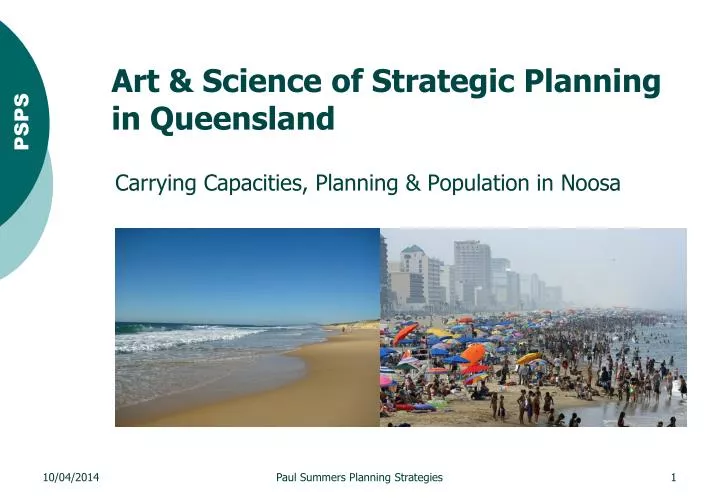
Art & Scienceof Strategic Planning in Queensland Carrying Capacities, Planning & Population in Noosa Paul Summers Planning Strategies
Introduction • Insights into: • Measuring the true cost of population growth – and getting it to one diagram! • Art and science of strategic planning – how is it done? • Population caps vs carrying capacities • Presentation based on an older one – but principles still apply Paul Summers Planning Strategies
Measuring the True Cost of Population Growth Paul Summers Planning Strategies
Potted History of Strategic Planning in Queensland • Prior to 1980 in Queensland, planning schemes were just about regulation – what you could do where and what process you followed • In 1980, Strategic Plans and Development Control Plans were introduced into the then Local Government Act – the legislation that controlled local planning • Strategic Plans evolved to become a vision together with overall strategic outcomes and implementation criteria for the City or Shire and the various places within it • By 1990, Strategic Plans had become a requirement of the then Local Government (Planning & Environment Act) • In 1998, the Integrated Planning Act removed the requirement for Strategic Plans and in fact prevented these types of instrument being a part of a planning scheme • In other words, Queensland went backwards • In 2009, the State re-introduced the ability for schemes to have limited strategic provisions via the Sustainable Planning Act – a strategic framework • In 2013 the State expanded the ability for better strategic provisions • We are almost back to where we were in 1990! Paul Summers Planning Strategies
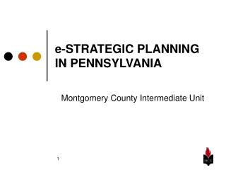
Strategic Plans • To gain an understanding on how these plans are done, we will examine a single location through three periods • An area to the south-east of the town of Cooroy, after de-amalgamation back in Noosa Shire Paul Summers Planning Strategies
1988 Strategic Plan Paul Summers Planning Strategies
1988 Characteristics • Little bit of art, not much science. • Where there was vision - it was often of the rear-view mirror variety: • Looked at where we had been – reflected the zoning scheme (the development control system). • Rarely was serious consideration given to where we were going, where we wanted to be or how we would get there. • Rudimentary development control systems. • Rudimentary tools with which to carry out the task. Paul Summers Planning Strategies
1988 Pluses & Minuses • Positive: • It was simple, because it was fairly rudimentary. • Didn’t cost a lot to do or to defend the position - there wasn’t much on which to argue. • Negative: • Extensive commitments, but little understanding of what the commitment really meant: • Little serious measurement of environmental capacity to support development. • Little serious measurement of the need for various land use commitments • Little serious measurement of the services necessary to provide for those commitments • Little serious measurement of the costs (real or otherwise) of provision of those services • Little serious communication of the real planning outcomes to the community (not sure we really understood them ourselves) • Focus on development control: leaving hard decisions until later • Focus on process: less clear on outcomes Paul Summers Planning Strategies
Strategic Planning: What It Should Be About • Focused on vision, not process • About planning for people and the places those people live, work and play • About what we want as communities, not what we don’t want • Positive, rather than negative • Fundamentally about making the hard decisions early Paul Summers Planning Strategies
Strategic Planning: About Making the Hard Decisions • Planning is about compromise and resolving differences between competing uses. • In planning, as in business, the earlier hard decisions are made the better. • Information is needed to make hard decisions and to choose how, when and what to compromise. • Geographic Information Systems (GIS) assists in the gathering and assimilation of data and can be also be used in the analysis and synthesis of information to aid the hard decisions. • The data needed to achieve this is surprisingly simple, but often difficult to come by. • So jumping to 1997 ... Paul Summers Planning Strategies
1997 Strategic Plan (Noosa) • Three critical exercises: • Analytical assessments of land’s: • Biophysical constraints • Environmental values • Suitability for various land uses • Analytical assessments of the infrastructure needed for the projected population/development and the capacity to fund that infrastructure • Consultation with the community on its desires for the Shire and the various places within it. • Next few slides focus on the land-based assessments Paul Summers Planning Strategies
1997 Land-Based Assessment using GIS • Primary datasets: • All science • Secondary datasets: • All science • Tertiary datasets: • Art, with a dose of science Paul Summers Planning Strategies
1997 Primary Datasets • What is the land? • Geology & Soils • What form does the land take? • Topography (Elevation & Slope) • What’s on the land? • Vegetation Paul Summers Planning Strategies
1997 Geology 22 classes • Czd • Czg • J-Kg • Qa • Qc • Qe • Qhm • Ra • Rc- Cedar Pocket Porphyry • R-Jy - Myrtle Creek Sandstone • Rlf -Keefton Formation • Rlk - Kin Kin Beds • Runl - North Arm Volcanics • Rw - Woondum Granite • Ta - Allandale Arfvedsonite Granite • Ti • Tp - Pomona Beds • Tv Paul Summers Planning Strategies
1997 Slope 6 categories • Flat 0-5% • Moderate 5-10% • Sloping 10-15% • Steep 15-20% • Severe 20-25% • Extreme >25% Paul Summers Planning Strategies
1997 Vegetation 8 types, 32 sub-types 1 Rainforest 2 Ecotonal forest 3 Eucalpyt forest 4 Melaleuca 5 Heathlands and sedgelands 6 Mangroves and saline communities 7 Frontal dunes and foreshores 8 Plantations Paul Summers Planning Strategies
1997 Secondary Datasets • All built from the three primary datasets • About the way in which humans: • Use the land; and • Value the land. Paul Summers Planning Strategies
1997 Agriculture 7 classes • Class A - GQAL • Class AT&V - Tree and vine crops - GQAL • Class B - GQAL • Class BS - Sugar - GQAL • Class C1 • Class C2 • Class D • Derived from soils and slope data (and developing an erosion hazard model and using rainfall data) Paul Summers Planning Strategies
1997 Bushfire 3 classes • Extreme bushfire hazard area • Bushfire-prone area • Not in a significant bushfire hazard area • Derived from slope and vegetation data (and developing aspect data and using fire history) Paul Summers Planning Strategies
1997 Extractive Resources 37 resources • Of which 14 were recommended for protection • Derived from geology data (and using slope and vegetation data, together with distance and road suitability data) Paul Summers Planning Strategies
1997 Landslip Hazard 4 classes • Negligible Potential • Significant Potential • Derived from geology and slope data Paul Summers Planning Strategies
1997 Waterways & Riparian Buffers 4 waterway classes: • Shire • District • Local • Tributary 4 riparian buffer classes: • 250 metres • 100 metres • 50-100 metres (mapped at 75 metres) • 50 metres • Derived from soil, vegetation and waterway data , (including status and tidal influence) and developing soil erodibility data Paul Summers Planning Strategies
1997 Other Mapping All up, more than 30 layers of GIS data were generated. Other key data included: • Acid sulphate soils data – derived from topographic and geology/soils data • Flooding – derived from topographic data • On-site effluent disposal suitability – derived from topographic, soils and vegetation data • Etc. Paul Summers Planning Strategies
1997 Art & Tertiary Datasets • Art: How the data needs to be combined to produce the tertiary information, which is the plan • Sieve mapping: • Starting with the what is known and can be accurately defined - science • Moving towards the things that are less tangible or less clear – where art is needed to produce a cogent result Paul Summers Planning Strategies
1997 GIS and the Hard Decisions • Using the GIS: • Working each end (the known) • Against the middle (the unknown) • Result is that the mapping merges biophysical constraints, environmental values with land use outcomes in a single layer. Paul Summers Planning Strategies
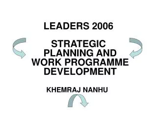
1997 Strategic Plan 1988 Paul Summers Planning Strategies
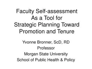
Moving Forward in Time, but Going Backwards • With the inability to have proper strategic provisions in plans in Queensland, planning schemes became weaker with less clarity • The integrated outcomes of 1997, had to be disintegrated in 2006 so: • Zoning tools; and • Biophysical constraints and environmental values were put in separate layers • The plans became coarser … Paul Summers Planning Strategies
2006 Noosa Plan • 1997 Paul Summers Planning Strategies
Population Growth: Is it inevitable? • A few years ago I presented on a question at the Woodford Folk Festival. • We were asked: Population Growth – is it inevitable? Should we just lie back and think of England ... • So I did ... Paul Summers Planning Strategies
Population Caps • Noosa’s so-called population cap doesn’t exist and cannot exist under a Westminster system of government • It has not been and never has been mentioned in any legal planning instrument • It was a political expediency to help sell the message and worked well in Noosa • Outside of Noosa most believe that the population outcomes were a target number set by politicians to which the planners worked • Nothing could be further from the truth. When adopting the final plan component, the pollies didn’t even know the final number • Witness what Queensland’s premier said: • ... a population cap was a simplistic solution that would place pressure on the economy. The only way we could really do that is to put a fence up at the (Queensland) border, or to cancel or freeze all new home building approvals (22/04/2007 - The Age) • 6 months later, even her own idea of building a fence, she rejected • ...it is my view that we need to actively embrace growth. I note comments early this week from one of our regional mayors that we should have a population cap. Well I don’t support that, even if I did I don’t think that I can constitutionally erect a barbed wire fence at the border... (16/10/2007 – Speech to Committee for Economic Development of Australia) Paul Summers Planning Strategies
Carrying Capacities • Remember the three critical exercises: • Analytical assessments of land’s: • Biophysical constraints • Environmental values • Suitability for various land uses • Analytical assessments of the infrastructure needed for the projected population/development and the capacity to fund that infrastructure • Consultation with the community on its desires for the City or Shire and the various places with it. • The result of measuring all this and putting in place policy consequences could be gauged in Noosa at the time, which was and is still growing albeit much more slowly, yet its water supply, sewerage, roads, etc. etc. were all secured and paid for. • By comparison, we could look at whether the Queensland Government has planned properly over the last couple of decades e.g. • There were frantic episodes with water in the period 2009-2012, as south-east Queensland ran out of raw water for even its existing population! • ¾ of the road funding for SEQ for 5 years was expended to build the Pacific Motorway – resulting in a commuter road to Brisbane for northern NSW residents • Queensland has not previously planned well for growth. Paul Summers Planning Strategies
State Reaction to Noosa’s Planning Paul Summers Planning Strategies
2004 – Former Minister for Local Government & Planning Desley Boyle • Minister Desley Boyle said: Welcome to Queensland, but keep on driving. You might like to live at Toowoomba or Crows Nest, or maybe you'd like to go north to Hervey Bay, or maybe continue right up the coast. • Addressing a group of Gold Coast developers, Ms Boyle said the State's southeast was becoming overcrowded, placing extreme pressure on infrastructure and the environment. She said it was dumb that everyone clustered in the southeast corner when Queensland was so large. (2004 - Courier Mail) Paul Summers Planning Strategies
Conclusions • Good planning relies on art as well as science – recently the art has disappeared and plans have become dry technical instruments. • The term population cap has reached its use-by date and should be dropped – carrying capacity is a far better term. • Population growth is not inevitable – if it was why would the Federal Government need a baby bonus? • Minister Boyle had the right idea and instead of denigrating the approaches carried out by Noosa Council, the Queensland Government should be listening hard. • More information: • Visit: www.paulsummersplanning.com.au • For a copy of the paper go to the web page and click Presentations & Publications in the menu Paul Summers Planning Strategies