Download
1 / 19
190 likes | 317 Views
Civil GPS Service Interface Committee (CGSIC). State and Local Government Subcommittee. Rudy Persaud U.S. DOT-FHWA APEC GNSS Implementation Team Seattle, WA June 23, 2010. Civil GPS Service Interface Committee.

E N D
Civil GPS Service Interface Committee (CGSIC) State and Local Government Subcommittee Rudy Persaud U.S. DOT-FHWA APEC GNSS Implementation Team Seattle, WA June 23, 2010
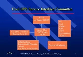
Civil GPS Service Interface Committee CGSIC is the World-Wide Forum Between Civil GPS Users and U.S. Government Service Providers Chair, DOT/RITA Deputy Chair CO, NAVCEN • Board • Aviation • Land • Marine • State • Subcommittee • Chairs Intl. Deputy Chair General Membership • Subcommittees • International • Timing • U.S. States &Localities • Surveying, Mapping, and Geo-Sciences
GPS is a Critical Component of the Global Information Infrastructure Satellite Operations Aviation Surveying & Mapping Precision Agriculture Communications Power Grids Disease Control Trucking & Shipping Personal Navigation Fishing & Boating Oil Exploration
GPS/GIS Inspection and Analysis Tools for Highway Construction Integrated GPS/GIS Application for Inspection and Analysis • FDOT’s Microstation drawings converted into Geographical Information System (GIS) Basemaps, with correction to the proper projections; Specifications; and Pay Items' Original Quantities. • Global Positioning System (GPS) Receivers Capture Pay Item Locations and Pertinent Dimensions for Quantities. • Database to Store Inspection Results: Observed Quality of Construction, Lab. Test Results, etc. and Digital Images • GIS Analyses and Database Queries Provide Monthly Display of Construction Progress and Estimate of Quantities, including As-Built Final Drawings and Quantities.
Minnesota Department of Transportation • Asset Management • Engineering • Resource Management • Emergency Management • Zoning & Planning • Education
Hawaii Department of TransportationVirtual Reference Station • What is VRS (Virtual Reference Station ) • •Real time centimeter measurements within the island-wide or state-wide network without setting up a base station
Estimated miles of leveling • Oahu Estimate of 211 miles • Maui Estimate of 251 miles • Kauai Estimate of 128 miles • Big Island Estimate of 410 miles
Maryland Department of Transportation Asset Data Warehouse • Initial Assets to be include in the Data Warehouse • Highway Characteristics • Pavement • Bridge/Structures • Drainage • ITS • Sidewalk
Pavement Condition • The ARAN uses a combination of high resolution video, ultrasonic sensors, accelerometers, gyroscopes and GPS to collect data at highway speeds • The Aran records cracking, rutting, roughness, grade, curve radius and more • It also records right-of-way video as a permanent record of roadway inventory
California Department of Transportation • U.S. DOT Partners with Caltrans for SafeTrip-21 • SafeTrip-21, is designed to improve safety and reduce congestion by identifying and harnessing existing technology and adapting it for transportation needs
U.S. DOT Partners with California Department of Transportation for SafeTrip-21 • Partnership will field test GPS-equipped cellular phones from up to 10,000 volunteer commuters and transit vehicles transmitting data from roads in a 200 mile radius to traffic management centers. • Commuters will have access to real-time traffic, transit and road safety information
Question: “There’s a rock in the road. How big is it?” Problem: How do you convey this information to someone who isn’t there, looking at the rock alongside you? A “Responder” Problem
What is Responder System? GPS Cellular modem Camera Tablet PC Satellite modem
National Geodetic Survey - CORS • Continuously Operating Reference Stations • 1800+ Stations • Several state DOT’s use CORS http://www.ngs.noaa.gov/CORS/