Download
1 / 27
380 likes | 1.13k Views
Archaeological Survey and Excavation. Survey and Excavation. Research Design Finding Archaeological Sites Excavation Types of Sites. Research Design. Design and Formulation Background Research Research design Implementation Funding Research team members Permission Data Acquisition

E N D
Survey and Excavation • Research Design • Finding Archaeological Sites • Excavation • Types of Sites
Research Design • Design and Formulation • Background Research • Research design • Implementation • Funding • Research team members • Permission • Data Acquisition • Field Research • Conservation • Initial Artifact processing • Processing and Analysis • Lab analysis • Curation • Interpretation • Final Report
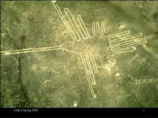
Finding Sites • Accidentally • Iceman-1991 • Lascaux • Archaeological Survey • surface survey • subsurface excavation • stp • auger • bank cuts • Remote Sensing • Ground penetrating radar • Electrical resistivity • Magnetometry • Aerial Photography • mounds • crop marks • Satellite Imagery • Geographic Information Systems (GIS)
Accidental: The Paleolithic Cave Paintings of Lascaux, France
Survey • Surface • Monitoring surface for artifacts, architecture • Subsurface • Shovel test pits-small tests into the ground • Augering-using soil augers to test under ground • Bank cuts-walking along river banks
Reading the Landscape • Archaeological Survey Design • Purpose of surveying is to map the physical remains of human activity • Surveys must be designed with project goals in mind • Geological Factors • Geological factors that affect preservation and visibility of sites must be considered
Reading the Landscape • Archaeological Survey Recovery Methods • Variety of techniques used including: • Walkover or shovel testing • Remote sensing • Magnetometry and ground-penetrating radar • Geographical Information Systems • GIS are software applications that enable archaeologists to bring together different types of spatial data and examine them together Global Positioning System (GPS) receivers help archaeologists determine the precise locations of archaeological sites
GeographicalInformationSystems Geographical information system (GIS) works by creating a series of georeferenced overlays.
Eastern Korinthia Archaeological Survey • Korinthia was one of the most important sources of trade and transport in the ancient Greek world • a source of raw materials and manufactured goods • a rich agricultural region. • The Eastern Korinthia Archaeological Survey Project • multidisciplinary regional study in this historically rich region. • expands upon previous scholarly research and add to the theory and practice of archaeological survey in an environmentally sensitive area. http://eleftheria.stcloudstate.edu/eks/
Research Questions • The particular research question is the relationship between eastern Korinthia, its main urban center, and the broader Mediterranean world. • For example, was the countryside cultivated mainly to serve the needs of an urban population or to produce a surplus for export? • If the latter, who was responsible: public officials, wealthy landowners, or individuals with small holdings? • Any of these possibilities may be in use at a given period. If the function of the agricultural sector changed over time, how can we track the process? • Equally relevant is the exploitation of natural resources such as fine limestone, iron ore, and high-grade clay.
Ground Penetrating Radar • Ground penetrating radar is a nondestructive geophysical method that produces a continuous cross-sectional profile or record of subsurface features, without drilling, probing, or digging. • Ground penetrating radar (GPR) profiles are used for evaluating the location and depth of buried objects and to investigate the presence and continuity of natural subsurface conditions and features. • Ground penetrating radar operates by transmitting pulses of ultra high frequency radio waves (microwave electromagnetic energy) down into the ground through a transducer or antenna. • The transmitted energy is reflected from various buried objects or distinct contacts between different earth materials. The antenna then receives the reflected waves and stores them in the digital control unit. http://www.geomodel.com/gprtext.htm
Electrical Resistivity • The resistance meter passes a small electrical current through the earth via a series of metal probes and measures the resistance of the earth to that current. • Although the earths resistance may vary according to a wide variety of factors, archaeological remains may be detected because of their effect on local resistance to a current. • Stone structures are relatively poor conductors. • Consequently, the presence of a wall may increase resistance and the feature will be represented as a positive anomaly. • Alternatively, a ditch or pit will usually allow a current to pass with relative ease (this is the result of the relatively high water content of such features). • These features will be shown as low resistance anomalies. • The depth to which the resistance meter can identify archaeological features when using a two probe array is dependant on the mobile probe separation.
Electrical Resistivity http://www.arch-ant.bham.ac.uk/bufau/research/bury_walls/technologies.htm
Magnetometry • The basis of survey using this instrument is very different to resistance survey. The magnetometer detects small changes in the earths magnetic field. • Although the earth has a permanent magnetic field which is subject to almost continuous global variations in direction and intensity, there are many localized factors which may also affect the field. • Many of these factors are natural in origin (the presence of volcanic rocks, for instance). However, part of this variation may have an archaeological origin and magnetometers may be used to detect this. • In particular burning may cause changes in iron compounds and transform them from non or weakly magnetic to magnetic forms. • Hearths and kilns, burnt clay and soil, bricks and tiles are good examples of archaeological objects or material which may cause such changes. Features such as pits and ditches may be filled with archaeological material and may be located because the contents of the features cause localized magnetic anomalies.
Aerial Photography Samarra' is a town on the east bank of the middle Tigris in Iraq, 125 km north of Baghdad, Between A.D. 836 and 892 it was the capital of the Abbasid Caliphs. Samarra’ expanded to an occupied area of 57 km², one of the largest cities of ancient times.
Excavation • Vertical Excavation • Digging limited areas for info on stratigraphy and dating • “Test Trenching” • Area Excavation • Horizontal excavation • “Block Areas” • Underwater • Tools • Backhoes, Bulldozers • Picks, shovels, trowels • Dental picks, brushes • Recording • Stratigraphy
ControllingHorizontal andVertical Space A datum point provides a point of reference for measuring depth while a grid provides a means of controlling horizontal space.
Types of Sites • Habitation Sites • Open campsites • Villages • Caves & Rockshelters • Earthworks • Mounds • Forts • First Warburton Excavation • Shell Middens • Ceremonial Sites • Architectural Sites • Burials and Cemeteries • Historic Sites http://www.youtube.com/watch?v=8hdPj9KwHJ0