Download
1 / 67
670 likes | 677 Views
New Datums: Replacing NAVD 88 and NAD 83. Professional Surveyors Association of Nebraska Winter Seminar Dave Zenk NGS Advisor February 9, 2018 Kearney, NE. Outline. Need to replace NAD 83 and NAVD 88 Customer Concerns Recent Decisions: Naming conventions and white papers

E N D
New Datums: Replacing NAVD 88 and NAD 83 Professional Surveyors Association of Nebraska Winter Seminar Dave Zenk NGS Advisor February 9, 2018 Kearney, NE Professional Surveyors Association of Nebraska
Outline • Need to replace NAD 83 and NAVD 88 • Customer Concerns • Recent Decisions: Naming conventions and white papers • Anticipated effects of datum change and how to prepare Professional Surveyors Association of Nebraska
Why replace NAVD 88 and NAD 83? • It’s the next logical step in a century old progression. • Migration from assumed coordinates, height, and direction to worldwide need to share unified datasets. • US Standard Datum -> NAD27 -> NAD83 -> NATRF2022 Assumed NORTH N=5,000 E=10,000 Ht=100 Professional Surveyors Association of Nebraska
Why replace NAVD 88 and NAD 83? • EXPANDS ACCESS! • easier to find the sky than to find a 60-year-old bench mark • GNSS equipment is cheap and fast • ENSURES ACCURACY! • easier to trust the sky than to trust a 60-year old bench mark • immune to passive mark instability • GLOBAL STANDARDS! • systematic errors of many meters across the US • aligns with GPS, international efforts • aligns with Canada, Mexico • GEOPHYSICS! • Gravity defines level surfaces • Satellite orbits based on gravitational center of mass Professional Surveyors Association of Nebraska
Dense as it is, it’s not everywhere! Professional Surveyors Association of Nebraska
Nebraska Passive Mark Network 12 mile radius Mark: MAJOR PID: MM0466 SET: 1933 REC: GOOD 1946 Shows only NGS Database marks. Local marks exist, too Professional Surveyors Association of Nebraska
Access to New Datum – Now and Future • In summary, access will be via GPS and OPUS. Here’s a sample of current OPUS output with highlighted items: REF FRAME: NAD_83(2011)(EPOCH:2010.0000) IGS08 (EPOCH:2016.5642) LAT: 44 59 16.25809 0.006(m) 44 59 16.28558 0.006(m) E LON: 266 30 48.71589 0.002(m) 266 30 48.67220 0.002(m) W LON: 93 29 11.28411 0.002(m) 93 29 11.32780 0.002(m) EL HGT: 272.794(m) 0.013(m) 271.868(m) 0.013(m) ORTHO HGT: 299.770(m) 0.024(m) [NAVD88 (Computed using GEOID12B)] And at bottom of the OPUS return: APPROX ORTHO HGT: 298.971 (m) [PROTOTYPE (Computed using xGeoid16B,GRS80,IGS08)] Location west of Minneapolis, MN Lat = + 0.846 m Lon = + 0.932 m Ell Ht = - 0.926 m Ortho Ht = - 0.799 m Black = current datums Red = future datums Professional Surveyors Association of Nebraska
NAVD 88 is tilted and biased compared to gravitational potential Professional Surveyors Association of Nebraska
passive marks are old Professional Surveyors Association of Nebraska
passive marks may lie still, but they still lie small instability x long time = inaccuracy Professional Surveyors Association of Nebraska
NAVD 88 is not America’s only datum • NAVD 88 North American Vertical Datum of 1988 • PRVD02 Puerto Rico Vertical Datum of 2002 • ASVD02 American Samoa Vertical Datum of 2002 • NMVD03 Northern Marianas Vertical Datum of 2003, 3 each • GUVD04 Guam Vertical Datum of 2004 • VIVD09 Virgin Islands Vertical Datum of 2009, 3 each • Hawaii … Hawaiian Islands Vertical Datum (coming soon) • various local datums, as national datum is inaccessible • IGLD 85 International Great Lakes Datum of 1985 • IGSN71 gravity dataset • GEOID12B geoid undulations • DEFLEC12B deflection of the vertical Will be replaced with one vertical datum - pole-to-equator Professional Surveyors Association of Nebraska
Multiple regional datums Professional Surveyors Association of Nebraska
Multiple regional datums replaced with one datum. Professional Surveyors Association of Nebraska
NAD 83 is non-geocentric hyy h83 Earth’s Surface This shift will cause changes in Lat, Lon, EllHt same GRS-80 ellipsoid IGS yy Origin ~2.2 meters NAD 83 Origin Professional Surveyors Association of Nebraska
Comparison of IGS08 and NAD83 These arrows are ~ 1.5 meters long These arrows are ~ 1.1 meters long Professional Surveyors Association of Nebraska
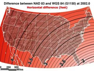
~ 1.3 meters (NW) in NE NAD 83(2011) to IGS08 at epoch 2022.0 Professional Surveyors Association of Nebraska
~ -0.9 meters in NE NAD 83(2011) to IGS08 at epoch 2022.0 Professional Surveyors Association of Nebraska
~ -0.75 meters in NE NAVD88 to NAPGD2022 Professional Surveyors Association of Nebraska
ITRF is now mature – worldwide research sites Professional Surveyors Association of Nebraska
ITRF is now mature – smaller changes each epoch ITRF2014 Professional Surveyors Association of Nebraska
NAD 83 is not ITRF • GPS & WAAS navigation uses WGS84, aligned to ITRF • satellite orbits and other geospatial datasets use global frames • our TRFs will agreewith ITRF (specifically, IGSyy) at the initial epoch • our TRFs will divergefrom ITRF by a few cm each year to stay “plate-fixed” • difference is a simple Euler plate rotation • many areas will diverge further, as no plate is perfectly rigid • plate-fixed or ITRF-fixed; can’t have both Professional Surveyors Association of Nebraska
Velocities, relative to IGS08 epoch 2005.00 Professional Surveyors Association of Nebraska
Velocities, relative to NAD83(2011) epoch 2010.00 Professional Surveyors Association of Nebraska
NAD 83 “versions” • NAD 83 (1986) • NAD 83 (HARNs) • NAD 83 (FBNs) • NAD 83 (NSRS) • NAD 83 (2011) • NAD 83 (PA11) • NAD 83 (MA11) • Replace with 4 plate-fixed frames • North America • Caribbean • Pacific • Marianas Professional Surveyors Association of Nebraska
Everything must shift RED: NAD 83 coastline against NAD 83 imagery GREEN: Coastline shifted into NATRF2022 but the imagery remains on NAD 83 Professional Surveyors Association of Nebraska
Summary: The NSRS in 2022… • Four semi-dynamic reference frames • Geoid/GPS based vertical datum • All data will be time tagged • All coordinates will come from GNSS surveys Professional Surveyors Association of Nebraska
Recap Previous Geospatial Summits • 2010 summit changes proposed • 2015 summit changes described • 2017 summit changes detailed reports, proceedings, presentations, and videos available on-line Professional Surveyors Association of Nebraska
tell us more! more updates, training, & tutorials a formal publication describing the differences between NAD 83 / NAVD 88 and the new reference frames help with legislation NSPS distribute sample language to update state legislation that references NAD 83 Customer Concerns control shouldn’t move! • a national terrestrial reference frame should minimize velocities, even if that means drifting away from ITRF/WGS84 over time. don’t make us think! • provide vendor- and user-friendly transformation tools with modern programming • modernize datasheets and bluebooking Professional Surveyors Association of Nebraska
Customer Concerns https://geodesy.noaa.gov/datums/newdatums/ tell us more! • more updates, training, & tutorials • a formal publication describing the differences between NAD 83 / NAVD 88 and the new reference frames help with legislation • NSPS distribute sample language to update state legislation that references NAD 83 ✓ ✓ control shouldn’t move! • a national terrestrial reference frame should minimize velocities, even if that means drifting away from ITRF/WGS84 over time. don’t make us think! • provide vendor- and user-friendly transformation tools with modern programming • modernize datasheets and bluebooking ✓ ✓ Subscribe for email notifications Professional Surveyors Association of Nebraska
Some recent decisions: Names and Blueprints by Dru Smith NSRS Modernization Manager NOAA’s National Geodetic Survey Professional Surveyors Association of Nebraska
Since 2008… • NGS has had two “ten year plans” • Heavy on broad sweeping decisions • e.g. “Replace NAD 83” • Light on details • How? What do we call it? • 2016 was a good year for filling in those details Professional Surveyors Association of Nebraska
So…what’s new? • Names Professional Surveyors Association of Nebraska
New Names The New: The North American Terrestrial Reference Frame of 2022 (NATRF2022) The Caribbean Terrestrial Reference Frame of 2022 (CATRF2022) The Pacific Terrestrial Reference Frame of 2022 (PATRF2022) The Mariana Terrestrial Reference Frame of 2022 (MATRF2022) The Old: NAD 83(2011) NAD 83(PA11) NAD 83(MA11) Professional Surveyors Association of Nebraska
New Names The Old: NAVD 88 PRVD 02 VIVD09 ASVD02 NMVD03 GUVD04 IGLD 85 IGSN71 GEOID12B DEFLEC12B Orthometric Heights The New: The North American-Pacific Geopotential Datum of 2022 (NAPGD2022) - Will include GEOID2022 Normal Orthometric Heights Dynamic Heights Gravity Geoid Undulations Deflections of the Vertical Professional Surveyors Association of Nebraska
Scientific Decisions • Blueprint for 2022, Part 1: Geometric • Four plate-fixed Terrestrial Reference Frames • And what “plate fixed” means • Mathematical equation between IGS and TRFs • Plate Rotation Model for each plate • Coordinates at survey epoch • Intra-frame velocity model • To compare coordinates surveyed at different epochs Other Blueprints: We are finalizing NOAA Technical Report NOS NGS 64, “Blueprint for 2022, Part 2: Geopotential Coordinates,” for an August 2017 release. The document describes the year 2022 replacement of all vertical datums and other NSRS geopotential quantities. It will serve as a companion document to NOAA Technical Report NOS NGS 62, “Blueprint for 2022, Part 1: Geometric Coordinates,” released in March of this year. Work has begun on Part 3 to address the re-invention of Bluebooking Professional Surveyors Association of Nebraska
Replacing the NAD 83’s • Three plate-(pseudo)fixed frames will be replaced with fourplate-fixed reference frames • N. Amer., Pacific, Mariana, Caribbean(new!) • Remove long-standing non-geocentricity of NAD 83 frames • All four : identical to IGSxx at a TBD epoch • 2020.00? • All four : differ from IGSxx by plate rotation only • Updated Euler Pole determination for rigid plate only Professional Surveyors Association of Nebraska
Four Frames/Plates in 2022 NATRF2022 MATRF2022 CATRF2022 PATRF2022 Image from Snay 2003 Professional Surveyors Association of Nebraska
Each frame will get 3 parameters • Euler Pole Latitude • Euler Pole Longitude • Rotation rate (radians / year) • This will be used to compute • time-dependent NATRF2022 • coordinates from time-dependent • IGS coordinates. North American Plate rotates CCW around its Euler Pole EULER Pole Professional Surveyors Association of Nebraska
NATRF2022 frame is rigid and fixed to rigid part of the N.A. plate Non-rigid part of the N.A. plate (deformation area) Rigid part of the N.A. plate Professional Surveyors Association of Nebraska
NATRF2022 coordinates over time(Remember: The NATRF2022 frame is rigid) Point on deforming part of plate Point on rigid part of plate l l EAST LONGITUDE EAST LONGITUDE t t TIME TIME Professional Surveyors Association of Nebraska
NATRF2022 coordinates over time(Remember: The NATRF2022 frame is rigid) Point on deforming part of plate Point on rigid part of plate l l EAST LONGITUDE EAST LONGITUDE t t Professional Surveyors Association of Nebraska
NATRF2022 coordinates over time(Remember: The NATRF2022 frame is rigid) Point on deforming part of plate Point on rigid part of plate l l EAST LONGITUDE EAST LONGITUDE t t Professional Surveyors Association of Nebraska
NATRF2022 coordinates over time(Remember: The NATRF2022 frame is rigid) Point on deforming part of plate Point on rigid part of plate l l EAST LONGITUDE EAST LONGITUDE t t Professional Surveyors Association of Nebraska
Intra-frame velocities This is the velocity of the point in NATRF2022. Rotation of plate removed. It is not constant because the point still suffers small “intra-frame” velocities. Such IFVs will be captured in a model by NGS. This is the velocity of the point in ITRF. Includes all movements, but the dominant one is the rotation of the N.A. Plate. Professional Surveyors Association of Nebraska
Scientific Decisions!! • Blueprint for 2022, Part 2: Geopotential • Global 3-D Geopotential Model (GGM) • Will contain all GRAV-D data • Able to yield any physical value on/above surface • Special high-resolution geoid, DoV and surface gravity products consistent with GGM • Not global: NA/Pacific, American Samoa, Guam/CNMI • Time-Dependencies • Geoid monitoring service • Impacts of deglaciation, sea level rise, earthquakes, etc Professional Surveyors Association of Nebraska
GEOID2022 (et al) over American Samoa: -16⁰ to -10⁰ latitude, 186⁰-193⁰ longitude GEOID2022 (et al) over Guam/CNMI: 11⁰ to 22⁰ latitude, 143⁰-148⁰ longitude GEOID2022 (et al) over the North America/Pacific/Caribbean/Central America/Greenland region will range from 0 to 90 latitude and from 170⁰ to 350⁰ east longitude (10⁰ to 190⁰ west longitude). Professional Surveyors Association of Nebraska
Blueprint for 2022 • Part 1: Geometric – now available April 2017 • Part 2: Geopotential – coming soon, Summer 2017 • Part 3: Bluebooking NOAA Technical Report NOS NGS 62 Blueprint for 2022, Part 1: Geometric Coordinates https://geodesy.noaa.gov/PUBS_LIB/NOAA_TR_NOS_NGS_0062.pdf Professional Surveyors Association of Nebraska
Time-Dependencies as a service:NATRF2022 and actual survey epochs NAD 83 forcibly combined data spanning many years (using HTDP with no vertical modeling) to compute and find one height at one epoch. NATRF2022 will compute coordinates at survey epoch to show actual motion. Even gridding surrounding CORS yields better subsidence rates than you have today. NAD 83 best estimate of dh/dt: +2.8 mm / year NATRF2022 best estimate of dh/dt: -4.2 mm / year Professional Surveyors Association of Nebraska CORS best estimate of dh/dt: -2.2 mm / year
Change and Preparedness Professional Surveyors Association of Nebraska
SHIFTS: 1.25 meters N&W x 0.75 meters VERT • Changes in Lat/Lon/EllHT and OrthoHt not negligible • Systematic shift over local areas • Paper maps – at scale of 1”=100 feet, change = 0.04” (1 mm) • So, overlays of new data on old data may be a concern. Professional Surveyors Association of Nebraska