Download
1 / 9
90 likes | 95 Views
WEGIS is a repository of official foundational GIS data and metadata from various sources, providing support for multiple enterprise business needs. It includes policies, standards, procedures, and best practices for infrastructure and content maintenance and security.

E N D
WEGIS ArcSDE Repository Lisa Morrison (DATCP) Project Lead
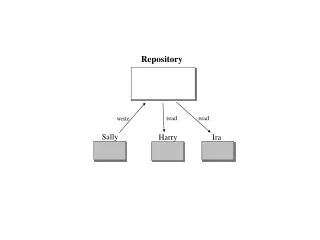
What is the repository? • Collection of “official” “foundational” GIS data and metadata from a variety of sources that support multiple enterprise business needs. • Policies, standards, procedures, and best practices that support the use, maintenance, and security of repository infrastructure and content.
What is the repository? • Oversight groups to address repository issues related to: • Repository services and service levels • Foundational GIS data acquisition and maintenance • Structure and content standards • Data models • Other
What is the repository? • Technology (HW/SW), data, and security infrastructures managed by DOA/DET • Effective and timely help for repository users provided by DOA/DET • Accessible to all Wisconsin state agencies and, ultimately, all State of Wisconsin customers as a DOA/DET service
WEGIS is not an attempt to consolidate all Wisconsin state agency GIS resources!
Business Needs Addressed… • Provides ArcSDE infrastructure to all Wisconsin state agencies that may want it • Makes official foundational GIS data and metadata available to all Wisconsin state agencies, and, ultimately, all Wisconsin customers
Business Needs Addressed… • Integrates with most existing GIS resources in Wisconsin state agencies • Facilitates data discovery and sharing among Wisconsin state agencies and with their partners and customers • Supports enterprise (and agencies) web mapping and GIS applications
Business Needs Addressed… • Saves money by consolidating the acquisition and management of repository infrastructure: • Server consolidation • Software licensing • Data acquisition and sharing agreements • User training and support • Data maintenance • Other
Project Status • Working on draft Business and Technical Requirements documents • Proof-of-concept • Less technical, more “trust building” • DOA/DET providing resources to effectively support the WEGIS repository and services