Download
1 / 36
370 likes | 642 Views
World Meteorological Organization Working together in weather, climate and water. WMO. WMO Integrated Global Observing System (WIGOS) Task Team to Regulatory Material Geneva, Swiss 19 – 24 Nov. 2012 Wenjian Zhang Director, Observing and Information Systems Department

E N D
World Meteorological OrganizationWorking together in weather, climate and water WMO WMO Integrated Global Observing System (WIGOS) Task Team to Regulatory Material Geneva, Swiss 19 – 24 Nov. 2012 Wenjian Zhang Director, Observing and Information Systems Department World Meteorological Organization
A challenge:The evolving observing systems The continuing changing observing system Courtesy, S. Brönnimann
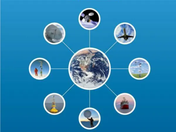
WMOINTEGRATED GLOBAL OBSERVING SYSTEM (WIGOS)---Background WMO Global Observing Systems • Global Observing Systems (WWW/GOS) • RBSN, RBCN (>10,000 stations,1,000 upper-air) • AMDAR (39754/day) • Ship & Marine obs (30417/day) • Surface-based remote sensing • Meso-scale networks • WMO Space Programme • Global Atmosphere Watch (GAW) • World Hydrological Cycle Observing System (WHYCOS) • WMO Co-sponsored Observing Systems • GCOS, GOOS, GTOS
WMO Cg-16 (2011) decisions to Implement WMOINTEGRATED GLOBAL OBSERVING SYSTEM (WIGOS) The key word is Integration: promote synergy among systems The whole is more than the sum of the parts--Aristotle Need an Integrated Global Observing System to meet all requirements in a cost –effective manner
EC-64 (June 2012):Approved WIGOS Implementation PlanExtraordinary Congress:WIGOS will contribute to Observations and Monitoring Pillar of GFCS Latest Major Decisions on WIGOS 8/25/2014 5
KEY ACTIVITY AREAS FOR WIGOS IMPLEMENTATION Management of WIGOS implementation (EC, RAs, TCs, ICG) Collaboration with WMO and co-sponsored observing systems (inclu. Space agencies & satellite operators) Design, planning and optimized evolution Integrated Observing System operation and maintenance Integrated Quality Management Standardization, system interoperability and data compatibility The WIGOS Operational Information Resource Data and metadata management, delivery and archival Capacity development Communication and outreach 6
How WIGOS contribute to GFCS ?Observing the Earth as a Complex System Surface Winds Precipitation Reflection and Transmission Evaporation Transpiration Surface Temperature Land • WMO systems collaboration (WIGOS oversight board within WMO) • Collaboration with space community • Collaboration with GCOS, GOOS, GTOS, GEO Atmosphere Infiltration Runoff Nutrient Loading Surface Temperature Currents Circulation Surface Winds Precipitation Reflection and Transmission Surface Temperature Evaporation Currents Upwelling Ocean
WIGOS Framework Implementation Plan Key Activity Areas for WIGOS Implementation2. Collaboration with WMO and co-sponsored OSs
WIGOS Framework Implementation PlanKey Activity Areas for WIGOS Implementation3. Design, planning and optimized evolution
WMO Rolling Requirements Review process Requirements Requirements Requirements Requirements Derived variables Performances Members’ organizations and programmes Space and ground-based instruments “Statement of Guidance”and Implementation Plan for observing capabilities(Actions,Recommend) Gap Analysison observations Dr. W. Zhang, WMO Presentation @ 9th European Space Weather Week, Brussels 10
VISION FOR THE GOS IN 2025 • Integration • The GOS will have evolved to become part of the WIGOS, which will integrate current GOS functionalities, which are intended primarily to support operational weather forecasting, with those of other applications: • climate monitoring, • oceanography, • atmospheric composition, • hydrology, and • weather and climate research;
VISION FOR THE GOS IN 2025 • Integration • Integration will be developed through the analysis of requirements and, where appropriate, through sharing observational infrastructure, platforms and sensors, across systems and with WMO Members and other partners; • Surface and space-based observing systems will be planned in a coordinated manner to cost effectively serve variety of user needs with appropriate spatial and temporal resolutions.
Observational Requirements under WIGOS Framework Inclusion requirements of WIGOS Space component From weather satellite to WIGOS space component CGMS new baseline with greatly enhanced global satellite constellations to meet WWW, GFCS, GAW, WHYCOS,GCW etc .. Operational requirements. Challenges to enhance greatly space and ground capabilities • Weather, DRR • Climate (GFCS, GAW..), • Water (WHYCOS,..) • Environment (GAW, Health) • Co-sponsored observing systems
WIGOS Framework Implementation Plan; Key Activity Areas 1. Management of WIGOS implementation
Res. 11.3/1 (Cg-XVI) -IMPLEMENTATION OF THE WMO INTEGRATED GLOBAL OBSERVING SYSTEM (WIGOS) • Decides to implement WMO Integrated Global Observing System (WIGOS) during 2012-2015 as one of the major efforts of WMO; • Requests The Executive Council to: • Monitor, guide & support the implementation of WIGOS; • Establish an Inter-Commission Coordination Group on WIGOS (ICG-WIGOS);
Three Legal Governance Pillars of WMO Since 1951, WMO Cg-I
Manage WIGOS Implementation through Integrated TR ---Setting WIGOS Regulations and Standards ---Promote recommended to standard practices and procedures Update WMO Technical Regulations: engage all observing systems
2.1.2 Missions The satellites should be equipped at a minimum to provide the following missions: (a) Imagery and sounding missions: satellites should be equipped to provide characteristics meeting user requirements to the greatest extent possible, independently or in conjunction with surface-based observations, quantitative data and qualitative information to enable determination of: (i) Fields of atmospheric temperature and humidity; (ii) Temperatures of sea and land surfaces; (iii) Wind fields at the surface and aloft; (iv) Cloud amount, cloud type, cloud top height and temperature, and cloud water content; (v) Precipitation; (vi) Snow and ice cover; (vii) Total column ozone; (viii) Vegetation cover; (ix) Radiation balance data. 2.1.2 Missions The satellites should be equipped at a minimum to provide the following missions: (a) Imagery and sounding missions: satellites should be equipped to provide characteristics meeting user requirements to the greatest extent possible, independently or integration with surface-based observations, data, products and information to enable determination of: (i) Fields of atmosphere: mainly: Temperature, humidity Greenhouse gases, total ozone and ozone profile, reactive gases Wind fields at the surface and aloft; Cloud amount, type, top height and temperature, and cloud water content; Precipitation, including chemical composition of precipitation; Earth radiation balance data (ii) Surface variables: mainly Temperatures of sea and land surfaces; different level of sub-surface Snow and ice cover, including ocean, polar regions and cryosphere; Soil moisture, hydrological variables Flooding areas, fires, Vegetation cover; Example: Revision of WMO Technical Regulations (Manual, etc) --- WIGOS Space component Current version Possible revised version
Conclusion remark • Benefits of WIGOS • Enhanced Members’ ability to meet expanding national mandates and achieve higher national and international visibility –including space agencies; • WIGOS provides a framework for improvedcollaboration and coordination within and beyond WMO; • WIGOS is both: challenges and opportunities for building up synergies among us, a win-win strategy for our future Thanks for your attention !!
WMO Cg-16 (2011) Decisions on Five Key Priorities for 2012-2015 Global Framework for Climate Services (GFCS) WMO Integrated Global Observing System/WMO Information System (WIGOS/WIS) Capacity building Disaster Risk Reduction Aeronautical meteorology 20
Credit of WMO: Great advances in Weather Forecasts with great CGMS contributions: Continue of success: in the Realm of Climate Services need even greater support from all WMO Members and Technical Commissions
WIGOS: http://www.wmo.int/pages/prog/www/wigos/index_en.html Merci Thank you Gracias شكرا 谢 谢 Спасибо
knowledge WIGOS will enhance developing value-added products and make them available to worldwide users for promoting satellite products utilization data Variables products Investment in Science and technology for quality products and utilizations
WIGOS Framework Implementation Plan v.1.0Key Activity Areas for WIGOS Implementation 5. Integrated quality management
Ensure the quality of the observations from space meet GFCS requirements Accuracy, PrecisionRepresentativenessMeasurement traceabilityLong-time series stabilityReducing uncertainty……
Global Space-based Inter-calibration System (GSICS) CMA-CNES-EUMETSAT-IMD-ISRO-JAXA-JMA-KMA--NOAA-NASA-NIST-Roshydromet-USGS-WMO LEO-LEO intercalibration • Routine IR inter-calibration against IASI and AIRS on simultaneous overpass • VIS and MW calibration under development GEO versus LEO More on: http://gsics.wmo.int Training event, Jincheon, Republic of Korea, October 2012
User Consultation Rolling Review of Requirements Performance Monitoring & QC Data for Applications Global Observing Systems Data Dissemination and Storage Design and Planning Operation & Maintenance Implementation WIGOS: OPERATIONAL CYCLE
Strategic Integration Multi-purpose Observations Global Standardization Data and Metadata Discoverability, Accessibility, Recoverablilty (DAR) Interoperability Data for Applications Compatability Global Observing Systems Measurement Traceability Agreed Observations Practices Spectrum Management WIGOS: KEY OPERATIONAL FEATURES Consult Users RRR Monitoring & QC Design and Plan Data Dissem and Storage Implement Operate & Maintain
Res. 2/2 (EC-LXIII) - INTER-COMMISSION COORDINATION GROUP ON THE WMO INTEGRATED GLOBAL OBSERVING SYSTEM (ICG-WIGOS) • Decides: To establish an Inter-Commission Coordination Group on the WMO Integrated Global Observing System (ICG-WIGOS) • Three EC Focal Points on ICG-WIGOS • Dr MOURA, PR of Brail, WMO first vice-president • Mr ČAČIĆ, PR of Croatia, President of RA VI • Mr SUTHERLAND, PR of Caribbean Met. Organization • Chair, Mr Branski, CBS President, at last CBS he delegated to VP of CBS, Sue • Members are Representatives from all WMO Technical Commissions and Regional Associations • Three Task Teams: • Task Team on WIGOS Implementation Plan (TT-WIP) • Task Team on WIGOS Metadata (TT-WMD) • Task Team on WIGOS Regulatory Material (TT-WRM) • In addition to ICG activities,
Processes to translate Services requirements into Observational specifications USERS’ satisfaction USERS’ needs Services Products Observation & Monitoring Instruments Service requirements: Content, Presentation, Delivery media, Timeliness, Continuity, User support, Training, .. Product requirements: Type (numerical, graphical, binary, alert), Algorithm, Spatial/temporal resolution, Quality control Observational requirements:Geophysical variable, Unit, Domain, Spatial resolution, Temporal resolution, Uncertainty … Datasets Source, Format,Projection, Segmentation, Quality flag, Compression,Metadata… Specifications: Instrument type, Orbit, Scanning mode, Spectral bands, Channel width, SNR, …
WIGOS Framework Implementation Plan v.1.0Key Activity Areas for WIGOS Implementation 6. Standardization, system interoperability and data compatibility
Observing Systems Capability Analysis and Review (OSCAR) concept www.wmo.int/oscar
Review of a capability: IR sounding from LEO PM Gap in early morning AM
8. Data and Metadata management, discovery, delivery and archival
WIGOS Metadata will enhance climate products generation: Orbital drift is most pronounced for afternoon satellites; NOAA - 7, 9, 11, 14. From Grody Eumetsat Conference, Darmstadt 2008