Download

1 / 28
280 likes | 286 Views
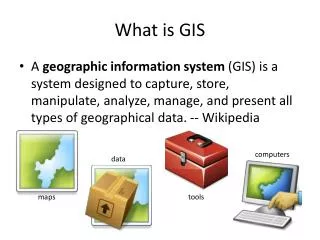
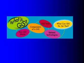
WHAT IS GIS. GIS – SOME DEFINITIONS. GIS may include manual systems, however, it usually refers to a computerised database system for capture, storage, retrieval, analysis and display of spatial data (Huxhold, 1991).

E N D
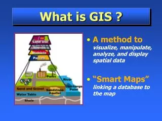
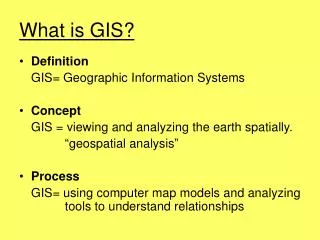
GIS – SOME DEFINITIONS • GIS may include manual systems, however, it usually refers to a computerised database system for capture, storage, retrieval, analysis and display of spatial data (Huxhold, 1991). • GIS is capable of assisting the storage, retrieval and manipulation of spatially referenced data such as street address or a census tract (Nedovic-Budic, 1999). • GIS is most useful when used to perform data analysis (Lee and Wong, 2001, viii)
GIS – SOME DEFINITIONS (cont.) • application • acts as a problem solving solution • example: water pollution, traffic, land management • toolbox • emphasize on the generic aspect of GIS in it’s definition • always used by vendors to maximize their market share
The History • First developed in North America, particularly the U.S. and Canada in the mid-1960s • Previously been used in natural resources and environmental research
Tutorial question • Briefly review the history of Geographic Information System application in Malaysia.
GIS: OLD AND NEW Traditional GIS MANUAL DRAFING TOOLS MAP TYPEWRITER New GIS COMPUTER PLOTTER CD-ROM
THE NEED FOR GIS • the real world has a lot of spatial data • manipulation, analysis and modeling can be effective and efficiently carried out with a GIS • the neighborhood of the intended purchase of house • the route for fire-fighting vehicles to the fire area • location of historical sites to visit • the earth surface for purposes of army • the earth surface is a limited resource • rational decisions on space utilization • fast and quality information in decision making
... THE NEED FOR GIS • complexity of management • due to the need to combine and process many sets of data, in addition to judge as many as possible, situation that might happen. • intense competition • the need to use technology in making decisions and strategy in the world of intense competition.
State Population (1991) Johor 2,074,297 Kedah 1,304,800 Kelantan 1,181,680 Melaka 504,502 A. DATA VISUALISATION Which one do you prefer: tabular data or map data? TABULAR DATA MAP
B. LOCATION EAST 10 11 12 P 3 4 5 SOUTH S Y • WHERE IS OBJECTP? • ANSWER: P = 3Y SOUTH, 12X EAST • WHAT CAN BE FOUND AT A CERTAIN LOCATION ? • EXAMPLE: What can be found at 5x SOUTH, 11y EAST? • ANSWER: Y
C. ATTRIBUTE QUESTION: 1. ATRIBUTE EXPLANATION EXAMPLE: WHAT IS THE ATTRIBUTE FOR ITEM 2? 2. WHERE A CERTAIN SENARIO MIGHT HAPPEN? EXAMPLE: WHO HAS THE HIGHEST QUALITY OF MINERALS ? NO. AREA (HECTARE) OWNER TAX CODE MINERAL QUALITY TALATU 1 100,000 B HIGH 2 50,100 BRAUDO A MEDIUM 3 90,900 BRAUDO B LOW 4 40,800 ANUNKU A LOW 5 120,200 SILIMA B HIGH
….QUESTION: RELATIONAL DATABASE NO. AREA (HECTARE) OWNER TAX CODE MINERAL QUALITY 1 100,000 TALATU B HIGH 2 50,100 BRAUDO A MEDIUM 3 90,900 BRAUDO B LOW 4 40,800 ANUNKU A LOW 5 120,200 SILIMA B HIGH 3. SELECTION OF AN AREA (ACCORDING TO RULES) EXAMPLE: WHICH ITEM HAS a) AREA >40,000 HECTARE b) OWNER: NOT SILIMA c) TAX CODE: B d) MINERAL QUALITY: HIGH
QUESTION: PATTERN AND RELATIONSHIP Z X Z Y Y X Y X Z Z 1. IS OBJECT X IN THE PATTERN? YES, IN THE FORM OF LINE, FROM NORTHWEST TO SOUTHEAST IN THE FORM OF A LINE 2. IS THERE A RELATIONSHIP BETWEEN X AND Y? YES, Y IS ALWAYS NEAR X 3. WHAT OTHER SPATIAL PATTERN EXISTS? OBJECT Z IS ALWAYS NEAR THE BORDERS AND ITS SIZE INCREASES FROM LEFT TO RIGHT
TREND QUESTION A A B B D C C 1980 1990 1. WHAT ARE THE CHANGES FOR A,B AND C FROM 1980 TO 1990? A: INCREASE IN SIZE B: DECREASE IN SIZE AND CHANGE IN LOCATION C: CHANGES IN SHAPE 2. WHAT HAS CHANGED SINCE 1980? A AND B HAVE CHANGED IN SIZE B RELOCATES C CHANGES IN SHAPE ADDITION OF ITEM D
GIS AND OTHER INFORMATION SYSTEMS Information System Spatial Information Systems Non-spatial Information Systems Management Information Systems Geographic Information Systems Other Types (CAD/CAM)
GIS USES VARIOUS DATA SOURCES VARIOUS DATA FORMATS AND 1 2 MAPS IMAGE DIGITAL PRODUCTS GPS TEXT DATA TABULAR DATA DATABASE MAPS REPORTS 3 4 4
GIS APPLICATION (I) • environment • management of natural resources • land, forest, marine, etc. • monitoring/control of environmental pollution • environment impact study • infrastructure • transport and irrigation management and maintenance • utility management and maintenance • electric, water, gas, telephone, etc.
GIS APPLICATION (II) • socio-economy • town and country planning • monitoring of population migration • disperse of resources/services • clinics, schools, etc • military • land form visualisation • visibility analysis
Residential Real Estate • A single map lets your customer compare multiple properties and their respective proximity to desired amenities such as schools, parks, and shopping centers. • Introduce the subject of disclosure by displaying FEMA floodplain data and know toxic sites in an area.
Commercial Real Estate • Evaluate and analyze key factors when siting new premise for restaurants, stores, warehouses, corporate offices etc.: * Proximity to suitable customers * Location of potential competitors * Crime rates * Transportation infrastructure * Regional labor pool characteristics * Environmental risk factors (i.e., flood plains, toxic sites, and others) • Real Estate Investment Trusts (REITs) can gain a competitive edge over traditional investments by using GIS to quantifying the investment potential of portfolios. • GIS can show properties in the context of potential customers/tenants, nearness to competitors, inventories of like property, labor pools, and risk factors.
Multiple Listing Services • Multiple Listing Services (MLSs) can add features and functions to the standard MLS menu of services such as an interactive map to show qualifying properties in the context of neighborhood amenities or perceived nuisances. Layers such as toxic sites can be added to address the sometimes thorny issue of disclosure. • A prospective buyer can browse listings, look at an appropriate map, and choose an agent without ever leaving home. A good Internet site can link visitors to agents' e-mails and office Web sites. • Mapping at the local level. Data such as parcel maps, school district boundaries, bus routes, local parks, and recreation facilities can be used by local MLS providers. • Internet Map Server (IMS) technology gives us the tools to publish maps on the internet.
Title Companies • Title companies can use GIS for relatively simple customer care mapping services, preliminary title searches, and the creation of GIS-based land information systems (LISs). • LIS projects can involve the conversion of an existing paper-based land registration/taxation system to an automated interactive GIS system. Projects also include the creation of GIS/LIS from historical records and aerial photogrammetry. • The title industry can also take advantage of internet-enabled GIS systems to allow free public access to a county's parcel ownership data and maps with a gateway to a fee-for-service section. • In the fee-for-service section, customers can order/down proprietary data and reports and initiate title searches. More innovative applications can be linked to a local real estate board or MLS provider and are of particular value to a wide range of real estate professionals.
Appraisers • Map current and recently retired listings for a more accurate representation of sales information for comparison. • GIS maps properties based on searchable features such as address and parcel number, so we can review all properties in a given area using these ‘connectors’ • ArcView GIS desktop software gives you the tools to map features that affect a property's value such as crime rates, environmental hazards, and the condition of surrounding neighborhoods and properties.
GIS USAGE Geomdk_id: 252 Area: 147: 147.477900 Geodmk_: 640 Account_no: A0546142 Owner: LAM MEE WONG No_k_p: 2224567 Bangsa: CINA Address: 142, JLN. BERJASA, TMN. TIMUR, KULAI, JOHOR Poscode: 81000 No_geran: GM 125 No_lot: PTD 12201 Area: BANDAR KULAI Mukim: SENAI-KULAI Holding: BEBAS Usage: KEDIAMAN Floors: 01 Assesment: 89000.00 Rate: 0.25 Tax: 222.50 Land Ownership MAJLIS DAERAH KULAI • Data recall
Modeling • predict information from data within the GIS • using a certain model Population Density Year 2010 - High - Medium - Low
BENEFITS OF GIS • improves/enhances the effects of physical/environmental growth • better management of resources • adding new value-added services • perform analysis on spatial and non spatial components • fast recall of data • ability for complex analysis • recalling of non spatial data through object location • display of information in a different light/view • multiple scenario in planning can be performed easily