Download
1 / 37
370 likes | 449 Views
VisKort/ShowMap a public sector open source success?. Speakers. Niels Kjøller Hansen GIS specialist Ringsted Kommune. Morten Kristoffer Hansen Project manager, Videncenter for OS og åbne standarder Digitaliseringsstyrelsen. Rasmus Espholm Program manager/architect, borger.dk

E N D
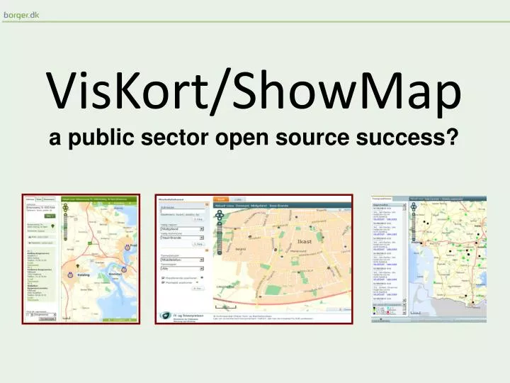
VisKort/ShowMap • a public sector open source success?
Speakers Niels Kjøller Hansen GIS specialist Ringsted Kommune Morten Kristoffer Hansen Project manager, Videncenter for OS og åbne standarder Digitaliseringsstyrelsen Rasmus Espholm Program manager/architect, borger.dk Digitaliseringsstyrelsen
Content - History - Introduction to ShowMap - Open source and the community - From the users perspective - Success?
Mastedatabasen History – How and why? Original goals and guidelines: • Loosely coupled map functionality • GIS for webeditors • Easy administration • Multible looks • Context specific information • Open source sorftware Later added: • Loosely coupled search functionallity • search results • webGIS • Community The future: • Mobility
Front end Tab Map List Tab Tab Functionality and data Map Navigation and zoom Theme Overview Scale
How does it work? The URL-configurator
How is it administrated? Web-administration
A couple og examples ShowMap with google maps Existing and planned antennas Region in Denmark
More examples Drawing Hørsholm Municipality
The core was build on open source VisStedet Geoserver The Core VisKort Openlayers
The core Core
Development Core Organisation 1
Development Core Organisation 1 Organisation 2
Development Core
Development Core
Development Core
Development AntennaDatabase VisPlaner borger.dk Climateadjustment ShowMap Kernen As a service …. Statstidende
Requirements and vendors «Requirement X.X: … and secure that the system efterwards can be maintained and developed upon by other suppliers …" ” Requirement X.Y: … The code must be transfered to the client …" " Requirement X.Z: … can be used freely by other public and private agencies and vendors
Open source – What do we hope to gain? - Based on existing solutions - Transparency - More competition, potentially - More with less - OOS-projects leads to standardization
Ownership - Take ownership of development - Give back to the community - Ask for OSS as a customer
Open source – What do we hope to gain? - Based on existing solutions - Transparency - Potentially more competition - More with less - OOS-projects leads to standardization
Community - status Members 57 members 20 organizations 3-4 suppliers Activity 3 meetings To releases: Code merge 11.02 Statstidende => 11.11
Community Core maintained by community Expansions, individual organizations Generalization – core expansion
The future Two releases a year 2-4 meetings Activity on the web Common public component? Mobility?
About me • A part of the danish Ubuntu community for, like, ever • Geographer • Works with GIS in the Ringsted Municipal Administration
First impressions Positive Open Source (Yay!) Community based (Woo!!) People behindseem to 'get' community. Not so positive Hard to find information Seemingly non-active/responsive forum No technical support forum to speak of.
Hard to find information Documents on digitaliser.dk: A projectdescription A list of contributors Scribbled notes from two meetings
Hard to find information (2) Documents on wiki Adminstratordocumentation (setup) Developer documentation (coding standards) Promises, promises, promises: What is ShowMap? Guide for new contributors Roadmap (outdated)
Non-active/responsive forum Forum on digitaliser.dk • 10 threads since december 2010 • 5 of them has no responses
No technical support forum Way of support: Through yoursupplier Which is fine for yourcompany's installation. But not for testing and/or private purposes
Various whining Runs only on Windows (.NET) No ”Installation for Dummies”-guide (ie. targetted at ME).
Recommendations An introduction to where to find resources and how to interact with the community in general. Basic installation guide Encouraginguse of the forum • ”Open Sourcing” the technical support from the suppliers
If you want to know more The community on Digitalisér.dk: • http://digitaliser.dk/group/375273 VisKort documentation (wiki): • http://viskort.org Demo: • http://viskort.dk Source code: http://view.svn.softwareborsen.dk/cgi-bin/index.cgi/Softwareborsen/viskort/
Contact: Niels Kjøller Hansen nkha@ringsted.dk / niels@geokonsulent.dk Morten Kristoffer Hansen Mortens digst mail Rasmus Espholm raesp@digst.dk