Download
1 / 22
300 likes | 548 Views
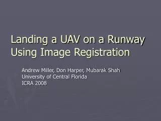
UAV LANDING SYSTEM. Submitted by: SHAKTI SINGH SHEKHAWAT SHRISH KUMAR SHUKLA RISHI KUMAR YADAV VINEET AGRAWAL. CONTENTS. INTRODUCTION-UAV’s UAV LANDING SYSTEM METHODOLOGY - VIDEO ANALYSIS - ATTITUDE MEASUREMENT CONCLUSION REFERENCES. UAV. WHAT IS UAV?

E N D
UAV LANDING SYSTEM Submitted by: SHAKTI SINGH SHEKHAWAT SHRISH KUMAR SHUKLARISHI KUMAR YADAVVINEET AGRAWAL
CONTENTS • INTRODUCTION-UAV’s • UAV LANDING SYSTEM • METHODOLOGY - VIDEO ANALYSIS - ATTITUDE MEASUREMENT • CONCLUSION • REFERENCES
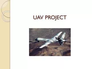
UAV • WHAT IS UAV? An unmanned aerial vehicle (UAV), commonly known as a drone, is an aircraft without a human pilot onboard. Its flight is either controlled autonomously by computers in the vehicle, or under the remote control of a navigator, or pilot (in military UAVs called a Combat Systems Officer on UCAVs) on the ground or in another vehicle.
UAV APPLICATIONS • Remote sensing • Commercial aerial surveillance • Oil, gas and mineral exploration and production • Transport • Armed attacks
UAV LANDING SYSTEM The experimental setup is constructed to resemble a scaled undercarriage of a helicopter. Five laser pointers and a high resolution web camera is mounted on the experimental setup. The laser pointers are mounted so that they can create the pattern illustrated in Figure 1.2.
If the helicopter moves up, the spots move away from each other. If the helicopter moves down, the pattern gets smaller until the spots are gathered in one spot when the helicopter is standing on the ground. If the helicopter is angled one of the distances, in either x-axis or y-axis depending on the angle, will be greater than the corresponding one. The web camera is mounted as close as possible to the middle laser pointer .
METHODOLOGY THE METHOD IS DIVIDED INTO TWO PARTS: VIDEO ANALYSIS FINDING DITANCES
The dimensions of the experimental setup seen from one angle
LASERS VS GPS • PLATFORM INDEPENDENT • NEVER GET LOST • CITIES • ACCURATE • CAMERA APPLICATIONS FIND SUITABLE AREA FOR LANDING SURVEILLANCE
LIDAR APPLICATIONS • Examples of military applications of LIDAR include the Airborne Laser Mine Detection System (ALMDS) for counter-mine warfare. • The Long-Range Biological Standoff Detection System (LR-BSDS) was developed for the US Army to provide the earliest possible standoff warning of a biological attack. It is an airborne system carried by a helicopter to detect man-made aerosol clouds containing biological and chemical agents at long range. The LR-BSDS, with a detection range of 30 km or more, was fielded in June 1997
Robotics LIDAR technology is being used in Robotics for the perception of the environment as well as object classification. The ability of LIDAR technology to provide three-dimensional elevation maps of the terrain, high precision distance to the ground, and approach velocity can enable safe landing of robotic and manned vehicles with a high degree of precision. • Surveying Airborne LIDAR sensors are used by companies in the remote sensing field.
Transportation LIDAR has been used in Adaptive Cruise Control (ACC) systems for automobiles. Systems such as those by Siemens and Hella use a lidar device mounted on the front of the vehicle, such as the bumper, to monitor the distance between the vehicle and any vehicle in front of it .In the event the vehicle in front slows down or is too close, the ACC applies the brakes to slow the vehicle. When the road ahead is clear, the ACC allows the vehicle to accelerate to a speed preset by the driver.
SHORT COMINGS • SENSOR STRENGTH • RESOLUTION OF CAMERA • BACKGROUND NEUTRALISATION • LANDING ON A MOVING OBJECT
CONCLUSION • In this project we have studied a new concept to estimate the attitude and the height of a helicopter. The concept is intended to be used as a modular sensor on a helicopter. • We had four goals in this projectand we believe that all of them now are fulfilled. We have estimated the attitude and height with an accuracy that is highly acceptable, regarding the conditions. • The experimental setup is built as an experimental setup to test the concept, it is not intended to be a final product.
FUTURE WORK • LANDING ON A MOVING SURFACE • IDENTIFYING SURFACES TO LAND • GOOD CAMERA AND SENSORS • HIGH ACCURACY USING KALMAN FILTERS • BUILT ON A MORE RIGID BASE
REFERENCES • Matworks, http://www.mathworks.com. • Principles of Helicopter Aerodynamics. Cambridge University Press, Gordon.J (2006) • Autopilot Unmanned Aerial Vehicle. National University of Singapore, Department of Mechanical Engineering .TeinHau, Tan (2008, May).
THANK YOU MATLABCODE