Download
1 / 50
510 likes | 637 Views
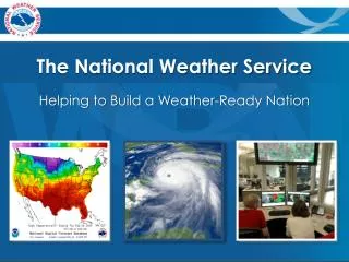
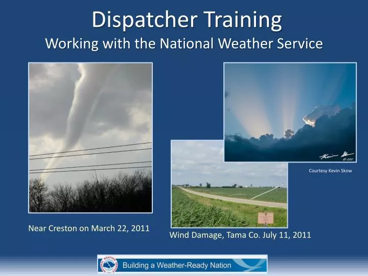
Dispatcher Training Working with the National Weather Service . Courtesy Kevin Skow. Near Creston on March 22, 2011. Wind Damage, Tama Co. July 11, 2011. What is the National Weather Service (NWS)? Understanding our role and services Severe weather for dispatchers

E N D
Dispatcher Training Working with the National Weather Service Courtesy Kevin Skow Near Creston on March 22, 2011 Wind Damage, Tama Co. July 11, 2011
What is the National Weather Service (NWS)? Understanding our role and services Severe weather for dispatchers What the NWS needs to know from dispatchers When to contact the NWS Optimizing communication Case Study Dispatcher Training Southern Iowa April, 2011
A federal government agency created by Congress, with roots back to the Civil War Part of NOAA – National Oceanic & Atmospheric Administration Mission:Protection of Life and Property What is the National Weather Service?
What is the National Weather Service? National Weather Service responsibility areas in Iowa
What is the National Weather Service? • Total staff of 23 people • 24 hour shift coverage • Rotating shifts • Provides continuous warning and forecast services National Weather Service Office Staffing and Operations
Understanding Our Role and Services National Weather Service Mission Statement "The National Weather Service (NWS) provides weather, hydrologic, and climate forecasts and warnings for the United States, its territories, adjacent waters and ocean areas, for the protection of life and property and the enhancement of the national economy.”
Understanding Our Role and Services • We can’t stop storms! • We can’t knock on every door and tell them it’s coming! • What can we do? How can we protect property and save lives?
Understanding Our Role and Services • Preparedness • Forecast and warning services • Dissemination of emergency messages Our goal is for people to make informed and educated decisions for themselves!
Understanding Our Role and Services In other words, Our job is to help you do your job!
Understanding Our Role and Services Watch - Hours to minutes Warning - Minutes Outlook - Days to hours Convective Warning Timeline
Understanding Our Role and Services “Emergencies” • Tornado Emergency – A destructive confirmed tornado which will likely move into a populated area resulting in serious property damage and a high potential for loss of life! • Flash Flood – A serious flash flood which will likely cause severe damage and a high potential for loss of life!
Impact Based Warnings Demonstration April 1-November 30, 2013 Key Points • Changes to warnings which emphasize communication of risk, clarifying impacts and use of “tags” to make important information easier to find • Demonstrated in parts of Kansas in Missouri in 2012 – Demonstration expanded to 11 states in 2013 including Iowa • Based on Service Assessments of 2011 tornado outbreaks (Joplin, southeast U.S. tornado outbreak) Courtesy NWS Springfield Joplin, Mo EF5 Tornado
Impact Based Warnings Max wind/hail tag Impacted locations (city list or pathcast Basis, location and movement Call to Actions Counties – best viewed graphically (New tornado tag in 2013) Severe Thunderstorm Warnings – 1 inch hail and/or 58 mph winds
Impact Based Warnings Basis, location and movement Impacted locations (city list and/or streams Call to Actions Counties – best viewed graphically Flash Flood Warnings – Imminent or occurring
Severe Weather for Dispatchers What is a Tornado? • A violently rotating column of air attached to a cloud base and in contact with the ground. • Exhibit rapid rotation and are most often laminar or smooth in appearance • Can have visible and invisible funnels • Usually vertically oriented Courtesy of Jeff & Amy Ruhland
Severe Weather for Dispatchers Tornado Types and Terms • Wedge – Large tornado • Invisible – A tornado without a condensation funnel • Funnel – Rotating column of air NOT on the ground • EF Rating – Enhanced Fujita rating which indicates a tornadoes strength Courtesy of Jeff & Amy Ruhland Funnel Cloud Invisible Tornado Wedge Tornado Courtesy of Rod Donavon
Severe Weather for Dispatchers Tornado Lookalikes • Scud • Rain-shafts Key to Know • Rotation? • Debris?
Severe Weather for Dispatchers Severe Straight-Line Wind Storms • Large area • Damaging straight-line winds (over 100 mph!) • Tornado-like damage! • Signature cloud – Shelf cloud • Siren considerations? July 11, 2011 Derecho Contour Legend Black: General Severe Winds (58 mph+) Yellow: Winds of 70mph +Red: Winds of 100 mph +
Severe Weather for Dispatchers Courtesy of Jim Snapp Shelf Cloud – June, 2010 July 11, 2011 Derecho Severe Straight-Line Wind Storm Examples
Severe Weather for Dispatchers Northern Iowa, August 9, 2009 Severe Hail Examples
Severe Weather for Dispatchers Flash Flooding • Difference between river and flash flooding • Life threatening – especially at night • Impact information often lacking in real-time Photos Courtesy of Des Moines Register / KCCI Mud Creek, August 2010
Severe Weather for Dispatchers Winter Weather • Snow / Ice amounts • Hazardous Travel Conditions • Winter weather impacts? Photos Courtesy of Alliant Energy
Severe Weather for Dispatchers Interested in Learning More? • National Weather Service Storm Spotter Training • Late February through April each spring • Two hour training in the evening • Check our website at www.weather.gov/dmx in January for the spotter training schedule • Will be available via webinar in 2013
Why does the NWS Call? It’s all about information – You have it and we need it! Remember our mission? The protection of lives and property. We can’t do it alone. We need you, the local experts!
Why does the NWS call? • Storm spotter information • Real-time spotter reports • Storm damage, injuries and fatalities • Assist with local warning decisions • Coordination • “Heads-up” prior to storm • Authenticate non-weather emergency messages
When to Contact the NWS • When you have weather-related reports • Spotter or public reports? Road closures? 911 outages? • For specific needs (weather, hazmat support, other?) • If you need clarification on a forecast or warning • To schedule a visit/tour of the National Weather Service • To let us know how an event went (feedback)
What is a Good Spotter Report? • Who? (Spotter or public?) • What? (Nature of the report) • Where? (reference nearest city, street address) Can use Latitude/Longitude • When? (time of event) • Movement? (direction and speed, if applicable) • Use proper terms • Damage, injuries or deaths? • Be as specific as possible!
When to Contact the NWS It is simply not possible for you to “bug” us More calls = High confidence High confidence = Accurate and Timely Warnings Remember that we are here to help you!
Optimizing Communications Text (LETS) Internet/e-mail Phone Voice/text NWSChat NAWAS/MICRN MICRN Phone NWSChat NAWAS Internet
Optimizing Communications • Email at: • dmx.spotterreport @noaa.gov • This is a spotter reporting e-mail account. NWSChat is a preferred method for dispatchers to use, but the email account is an option How to contact the NWS
Optimizing Communications • Spotter hotline SKYWARN number: • 1-800-SKYWARN (1-800-759-9276) • We also receive spotter reports via text messaging at: • (515) 240-5515 How to contact the NWS
Optimizing Communications NWSChat • Private, secure chat and instant messaging service between NWS, dispatch offices and Emergency Managers. • Ability to quickly share and view information from NWS and nearby counties. • Includes automated weather feed which is the fastest way to receive NWS warnings. • Feed includes ability to graphically display radar info and exact warning areas. • Great for siren activations. • For additional information contact Senior Forecaster Brad Small at: • bradley.small@noaa.gov How to contact the NWS
Optimizing Communications MICRN – Metro Incident Command Radio Network Eight central Iowa counties with over 40 agencies on the network How to contact the NWS
Optimizing Communications NAWAS/IOWAS Iowa State Patrol Warning Point areas and IOWAS locations Red- ISP Warning Points Blue-Other IOWAS locations All NWS offices have a line How to contact the NWS
Optimizing Communications Social Media? • Twitter – Use #iawx to send a Twitter report • Facebook – NWS Des Moines has a Facebook page. It’s a great page to follow. Storm, and storm damage pictures and videos should be posted How to contact the NWS
Case Study – Tornado Event Outlook Phase: 12-72 hours in advance • NWS Products – Storm Prediction Center (SPC) Convective Outlooks, NWS Des Moines Hazardous Weather Outlooks • Enhanced NWS Decision Support Services - Severe weather risk may be highlighted in the NWS Weather Story Madison County EF2 Tornado Event – March 22, 2011
Case Study – Tornado Event Outlook Phase: 6-12 hours in advance • NWS Products – SPC Convective Outlooks, NWS Des Moines Hazardous Weather Outlooks • Enhanced NWS Decision Support Services - Headlined on DMX website, risk sent through Social Media, emergency manager webinar held, multi-media web briefing on NWS website Madison County EF2 Tornado Event – March 22, 2011
Case Study – Tornado Event Outlook Phase: 6-12 hours in advance • Possible dispatcher actions (with respect to the NWS) • Notification of spotter groups? • Watch NWS web briefing? • Other coordination or actions? • Verify NWS communications such as NWSChat account Madison County EF2 Tornado Event – March 22, 2011
Case Study – Tornado Event Watch Phase: 0-6 hours in advance • NWS Products – SPC Watches (is it a Potentially Dangerous Situation (PDS) watch? ), possible NWS Des Moines Special Weather Statements (SPS) • Enhanced NWS Decision Support Services – “Occasional” NWS calls to dispatch offices to coordinate prior to warning, risk highlighted on website and possibly through Social Media Madison County EF2 Tornado Event – March 22, 2011
Case Study – Tornado Event Watch Phase: 0-6 hours in advance • Possible dispatcher actions (with respect to the NWS) – • Notification of spotter groups? • Watch dissemination? • Coordinate with emergency manager or spotter net controller (amateur radio?) • Contact NWS with questions? • Phone, Chat, MICRN, etc. NWS Des Moines communications desk, March 22, 2011 Madison County EF2 Tornado Event – March 22, 2011
Case Study – Tornado Event Warning Phase: 0-1 hour in advance • NWS Products – NWS warnings, Local Storm Reports (LSR), watch updates • Enhanced NWS Decision Support Services – “Occasional” NWS calls to dispatch offices to coordinate during warnings, dissemination of warning products, risk highlighted on website and possibly through Social Media Courtesy of Iowa Environmental Mesonet NWS Tornado Warning issued at 544 PM CDT, March 22, 2011 Madison County EF2 Tornado Event – March 22, 2011
Case Study – Tornado Event Warning Phase: 0-1 hour in advance • Possible dispatcher actions (with respect to the NWS) - • Relaying spotter reports to NWS – using fastest communication system? • Local warning dissemination – siren activations? • Coordinate with emergency manager or spotter net controller (amateur radio?) - are they in charge of relaying reports to NWS? • Contact NWS with questions? • Phone, Chat, MICRN, etc. Storm Motion Favored area for mobile spotter deployment Courtesy of Iowa Environmental Mesonet NWS Tornado Warning issued at 444 PM March 22, 2011 Madison County EF2 Tornado Event – March 22, 2011
Case Study – Tornado Event Warning Phase: Tornado in progress • NWS Products – NWS Severe Weather Statements (SVS), LSR’s, new warnings?, “emergency” wording in warning/statement? • Enhanced NWS Decision Support Services – “Occasional” NWS calls to dispatch offices to coordinate during warnings, dissemination of warning products, risk highlighted on website and possibly through Social Media Tornado in southwest Iowa, March 22, 2011 Brad Nelson NWS Des Moines Warning Team March 22, 2011 Madison County EF2 Tornado Event – March 22, 2011
Case Study – Tornado Event Warning Phase: Tornado in progress • Possible dispatcher actions (with respect to the NWS) - • Relaying spotter reports to NWS – using fastest communication system? • Local warning dissemination – siren activations? • Coordinate with emergency manager or spotter net controller (amateur radio?) - are they in charge of relaying reports to NWS? • Contact NWS with questions? • Phone, Chat, MICRN, etc. Tornado in southwest Iowa, March 22, 2011 Brad Nelson Courtesy of Iowa Environmental Mesonet Radar and warning display valid at 614 PM CDT. Reported hail and tornado locations provided Madison County EF2 Tornado Event – March 22, 2011
Case Study – Tornado Event Post Event • NWS Products –Watch/Warnings cancelled or expired, LSR’s issued • Enhanced NWS Decision Support Services – Possible call to the county to finalize initial damage estimates, coordination with the county concerning damage survey activities, conducting survey in coordination with the emergency manager the following day(s). Storm Survey results are released to the media and placed on the NWS website. NWS Des Moines Storm Surveyor providing a media interview in the field, May, 2011 Madison County EF2 Tornado Event – March 22, 2011
Case Study – Tornado Event Storm Survey results for Madison County March 22, 2011 Tornado damage locations • EF2 Tornado – Peak wind of 120 mph • Length – 11 miles • No injuries or deaths! Tornado damage
Help us improve… • What could we do better? • Recent Problems? • Let us know… • Call or E-mail:Jeff Johnson National Weather Service Des Moines, IA jeff.johnson@noaa.gov 515-270-4501 Ext.726
Thank you!!! National Weather Service Des Moines, IA