Download
1 / 52
530 likes | 672 Views
Landscape of Remembrance: Spatial Distribution of New Orleans Katrina Commemorations. Mike Winiski Greenville, SC. http://www.flickr.com/photos/navillusphotography/3626506521/sizes/z/in/photostream/. http://www.flickr.com/photos/midnightquill/416540958/sizes/z/in/photostream/.

E N D
Landscape of Remembrance: Spatial Distribution of New Orleans Katrina Commemorations • Mike Winiski • Greenville, SC
http://www.flickr.com/photos/navillusphotography/3626506521/sizes/z/in/photostream/http://www.flickr.com/photos/navillusphotography/3626506521/sizes/z/in/photostream/
http://www.flickr.com/photos/midnightquill/416540958/sizes/z/in/photostream/http://www.flickr.com/photos/midnightquill/416540958/sizes/z/in/photostream/
http://www.flickr.com/photos/13023662@N07/2095391083/sizes/l/in/photostream/http://www.flickr.com/photos/13023662@N07/2095391083/sizes/l/in/photostream/
http://www.artscouncilofneworleans.org/article.php?story=20081208164221496http://www.artscouncilofneworleans.org/article.php?story=20081208164221496
http://www.pbs.org/arts/gallery/ruin-and-revival/storm-cycle-slideshow/http://www.pbs.org/arts/gallery/ruin-and-revival/storm-cycle-slideshow/
http://photos.nola.com/photogallery/2010/08/hurricane_katrina_body_art_9.htmlhttp://photos.nola.com/photogallery/2010/08/hurricane_katrina_body_art_9.html http://photos.nola.com/photogallery/2010/08/hurricane_katrina_body_art_15.html http://photos.nola.com/photogallery/2010/08/hurricane_katrina_body_art_43.html
Purpose • Remember • Grieve • Honor lost loved ones • Hold accountable / Ascribe responsibility • Express anger • Confirm community through shared experience • Tell stories • Express hope • Promote understanding within and beyond community
“Only by remembering, and holding city, state, and federal government officials responsible for their actions, can a true Gulf South rebuild commence in the appropriate fashion” (Brinkley, 2007, p.xxv). “From this day forward, the Memorial will be a constant reminder not only of what we have endured, but also of our ability to come together, in the wake of tragedy, with limitless compassion” (Daniels, 2011).
Axioms of Resilience • “In the aftermath of disaster, the very legitimacy of government is at stake. Citizens have the opportunity to observe how their leaders respond to an acute crisis and, if they are not satisfied, such events can be significant catalysts for political change” (Vale & Campanella, 2005, p. 340). • 4. “Local Resilience is Linked to National Renewal” • 5. “Resilience is Underwritten by Outsiders” • 7. “Remembrance Drives Resilience” • 9. “Resilience Exploits the Power of Place” • 10. “Resilience Casts Opportunism as Opportunity” • (Vale & Campanella, 2005)
Exclusion “Cultural, just as individual memory is an extremely narrow space regulated by rigid principles of selection and forgetting. Those who examined the borderline—Gray speaking for the poor peasants, Woolf speaking for women, Ellison speaking for African Americans—were for the first time calling attention to the structural mechanisms that exclude whole groups of the population from active participation in the cultural memory” (Assmann, 2009, p. 48).
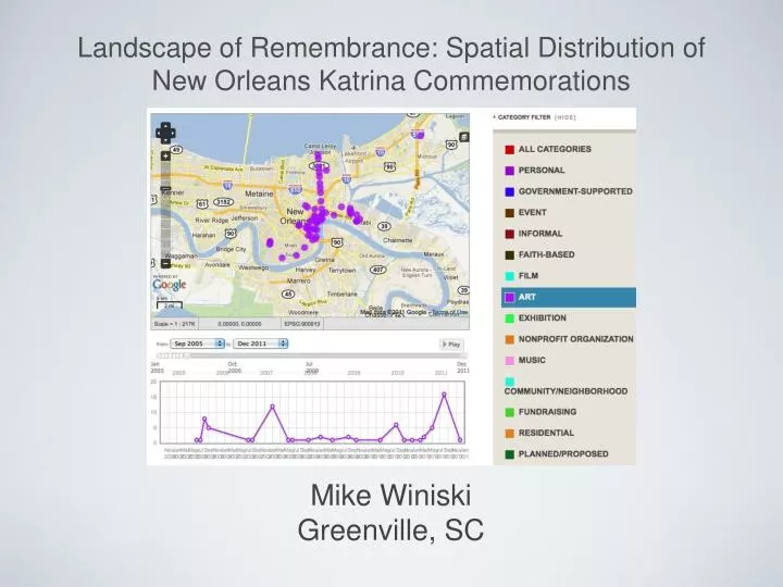
How do the locations and forms of Katrina commemorations (both formal and informal) in greater New Orleans correspond to storm impact? • Are certain contingents, as represented by place and demographics, excluded from the commemoration process? • Do the form and nature of these commemorations vary across the city and different neighborhoods? If so, how? • Research Questions
Defining / Quantifying ‘Impact’ • Defining Commemoration and Category • Data Collection • Analysis • Methodology
Death Rate (The Times Picayune, 2009)
Return Rate (Park & Tse, 2010)
Return Rate (Park & Tse, 2010)
Has a discernible location (temporary or permanent) • Visibly invokes a remembrance of Katrina event • Invokes memory of event or collective loss, rather than individual memorials (grave markers, etc.) • Defining Commemoration
“In truth architecture defines our daily lives ... how we get up in the morning, how we move through our cities, in what conditions we will complete our work, and where our kids will play. We remain creatures susceptible to our environment. Whether this existence be harmonious or cumbersome, it is architecture which hones our memories” (Feireiss and Pitt, 2009, p. 470). • Brad Pitt http://www.makeitrightnola.org/index.php/work_progress/mir_homes/1809_deslonde_street/
1) To what degree, if any, is the distribution of commemorations and types spatially autocorrelated across the entire study area? -Univariate Moran’s I; 2) Which local units have the most significant impact on the overall degree of spatial autocorrelation? -LISA (Local Indicators of Spatial Association) / simulation via Monte Carlo methods; 3) Do the local units with the most significant impact on spatial autocorrelation correspond to areas of high ‘impact’, poverty, or high minority percentage? *Exploratory Data Analysis (EDA) possibly performed with Geoda • Analysis
Significance map of Auckland City created by Mike Winiski in Geography 586 (Lesson 8) using Geoda and data from https://www.e-education.psu.edu/geog586/book/export/html/1817
Do we have enough data to allow for analysis at the neighborhood level, or will analysis require a higher level of aggregation--like planning districts? • Sampling bias • Resolving discrepancies in death rates / Data access • New Orleans East • Outsider • Statistically analyzing changes over time • Challenges and Questions
“A good map tells a multitude of little white lies; it suppresses truth to help the user see what needs to be seen. Reality is three-dimensional, rich in detail, and far too factual to allow a complete yet uncluttered two-dimensional graphic scale model. Indeed a map that did not generalize would be useless” (Monmonnier, 1996, p.25).
Thanks to my advisor Lorraine Dowler for her expertise, encouragement, tough questions, and guidance; • Ronald Lewis, R. Omar Casimire, and the residents of New Orleans; • Drew Woten and Diane Boyd, Furman University; • Susannah, Emma, and Jordan Winiski. • Acknowledgements