Download
1 / 16
160 likes | 263 Views
Explore the launch history and operational details of MTSAT and GMS satellites, including launch dates, vehicles, sites, and current status. Learn about the Command and Data Acquisition Station, MTSAT-1R/2 operations, AMV dissemination, and observation configurations. Stay updated on MTSAT-2 operations, changeovers, and RARS data monitoring. Discover the Himawari-8/9 project schedule, specifications, and ground sub-system details for AHI and satellite buses. Immerse in the comprehensive overview of these important meteorological satellites.

E N D
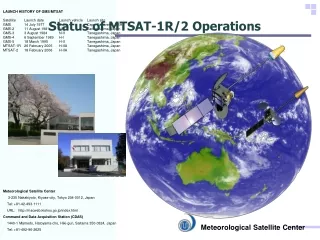
LAUNCH HISTORY OF GMS/MTSAT Satellite Launch date Launch vehicle Launch site GMS 14 July 1977 Delta Cape Canaveral, USA GMS-2 11 August 1981 N-II Tanegashima, Japan GMS-3 3 August 1984 N-II Tanegashima, Japan GMS-4 6 September 1989 H-I Tanegashima, Japan GMS-5 18 March 1995 H-II Tanegashima, Japan MTSAT-1R 26 February 2005 H-IIA Tanegashima, Japan MTSAT-2 18 February 2006 H-IIA Tanegashima, Japan Status of MTSAT-1R/2 Operations Meteorological Satellite Center 3-235 Nakakiyoto, Kiyose-city, Tokyo 204-0012, Japan Tel: +81-42-493-1111 URL:http://mscweb.kishou.go.jp/index.html Command and Data Acquisition Station (CDAS) 1440-1 Mamedo, Hatoyama-cho, Hiki-gun, Saitama 350-0324, Japan Tel: +81-492-96-2625 Meteorological Satellite Center
Status of MTSAT-1R/2 Operations • MTSAT-2 operation was started on July 2010. • Because of a ground system trouble and ground system maintenance, a backup operation by MTSAT-1R was conducted from October to December 2010. • The trouble was induced by solar-noise at sun interference period. • The backup operation by MTSAT-1R is also planned during this year’s ground system maintenance, which is scheduled from November to December. • MTSAT-2 hourly AMVs dissemination via GTS started on 28 March 2011 • Before, 3 hourly over the N.H., 6 hourly over the S.H. • Now, MTSAT AMVs are derived from successive images of 15, 30 and 60 minutes intervals, that vary depending on the AMV production. The intervals can be found in the table shown on the next slide, or computed from MTSAT images observation times contained in AMV BUFR data.
Observation/Direct Broadcast Configurations by MTSAT-1R/-2 after July 2010 • Observation: MTSAT-2 (145 E) • Direct Broadcast: MTSAT-1R (140 E) • Imagery Data Format • HRIT (for MDUS users) • LRIT (for SDUS users) • Imageries • 24 full disk images • 24 northern hemisphere images • 8 southern hemisphere images MTSAT-1R (140 deg E) MTSAT-2 (145 deg E) Imagerraw data Imagery (Direct Broadcast) Imagery (HRIT/LRIT) JMA/MSC SDUS MDUS MTSAT-1R back to operation during MTSAT-2 or its ground system maintenance
Status of MTSAT-1R/2 Operations • MTSAT-2 operation was started on July 2010. • Because of a ground system trouble and ground system maintenance, a backup operation by MTSAT-1R was conducted from October to December 2010. • The trouble was induced by solar-noise at sun interference period. • The backup operation by MTSAT-1R is also planned during this year’s ground system maintenance, which is scheduled from November to December. • MTSAT-2 hourly AMVs dissemination via GTS started on 28 March 2011 • Before, 3 hourly over the N.H., 6 hourly over the S.H. • Now, MTSAT AMVs are derived from successive images of 15, 30 and 60 minutes intervals, that vary depending on the AMV production. The intervals can be found in the table shown on the next slide, or computed from MTSAT images observation times contained in AMV BUFR data.
MTSAT-2 Atmospheric Motion Vector products Yellow: Newly disseminated AMVs from 03UTC 28th March 2011 Blue: Continuously disseminated AMVs
Changeover of MTSAT AMV and CSR Codes • CBS-XIII Recommendation 4 (2005) • BUFR editions 3 and 4 may be used in parallel up to the first Tuesday of November 2012; after that date only BUFR edition 4 shall be used; • Now • JMA now provides MTSAT AMV and CSR data in BUFR edition 3 • Plan • JMA plans to change the codes of AMV and CSR to BUFR edition 4 around the end of 2011 • The impact of the change is only in the header. The products themselves remain unchanged • Announcement with detailed information will be made two-month prior to the changeover • Test files will be provided to users with the announcement
RARS Data Acquisition Monitoring Webpage • The monitoring Webpage resumed from March 2011http://mscweb.kishou.go.jp/rars/time_index.htm
Status of Himawari-8/9 Project prepared by Toshiyuki KURINO, Senior Coordinator for Meteorological Satellite Systems Satellite Program Division, Japan Meteorological Agency
Schedule(updated) • JMA has made a contract with Mitsubishi Electric Corp. (MELCO) for the manufacture of Himawari-8/9in July 2009 • JMA has made a contract with Himawari OPeration Enterprise Corp. (HOPE) for the operation of Himawari-8/9in September 2010 • JMA plans to launch Himawari-8 in 2014and begin its operation in 2015 • The launch of Himawari-9 for in-orbit standby is also scheduled in 2016 • Himawari-8/9 will be in operation around 140 degrees East covering the East Asia and the Western Pacific
Schedule Himawari-8 Himawari-9 AHI ▲EQSR ▲CDR Satellite BUS ▲PDR ▲CDR ▲PDR Ground Sub-System EQSR: Equipment Qualification Status Review PDR: Preliminary Design Review CDR: Critical Design Review ▲CDR
Star Tracker AHI (Advanced Himawari Imager) Ka-band Antenna Ku-band Antenna UHF-band Antenna Solar Array Panel Appearance of Himawari-8/9 DS-2000 Imager Bench Space Environment Data Acquisition Montor (SEDA)
Region1 N-E JAPAN Region2 S-W JAPAN Region 3 Typhoon Region 4 Land mark Region 5 Land mark AHI Sectored Observations in 10 minutes Full disk Interval : 10 minutes (6 times per hour) 23 swath Region 1 JAPAN (North-East) Interval : 2.5 minutes (4 times in 10minutes) Dimension : EW x NS: 2000 x 1000 km 2 swath Region 2 JAPAN (South-West) Interval : 2.5 minutes (4 times in 10minutes) Dimension : EW x NS: 2000 x 1000 km 2 swath Region 3 Typhoon Interval : 2.5 minutes (4 times in 10minutes) Dimension : EW x NS: 1000 x 1000 km 2 swath Region 4 Land mark Interval : 0.5 minutes (20 times in 10minutes) Dimension : EW x NS: 1000 x 500 km 1 swath Region 5 Land mark Interval : 0.5 minutes (20 times in 10minutes)Dimension : EW x NS: 1000 x 500 km 1 swath