Download
1 / 40
420 likes | 1.04k Views
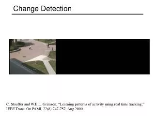
GIS to DSM fusion and basic change detection. Timothée Bailloeul 11 Dec, 2003. Results over Beijing area - zoom Asian Games Stadium – Beijing (1999) Introduction

E N D
GIS to DSM fusion and basic change detection. Timothée Bailloeul11 Dec, 2003.
Results over Beijing area - zoom • Asian Games Stadium – Beijing (1999)
Introduction • Background : some Digital Surface Models (DSMs) have been generated from aerial images (urban environment). DSM are coarse and have pixels with no altitude info. • Issue : we want to merge the DSM information with the building layer of GIS data to : • Add a third dimension to the GIS data : 2D 3D • Check out if GIS-to-DSM change detection is possible • Key points : • How to merge GIS and DSM data ? • Quantify the change detection method
Introduction • Here results towards GIS-to-DSM fusion using geocoding information will be presented. • Quantifying the DSMs geocoding accuracy is then essential. • Geocoding information will also be used to merge the generated DSMs. • A simple method aiming at detecting changes between GIS data (old) and the DSM (new) was carried out.
Contents • DSM geocoding quality evaluation • DSMs merging • Basic change detection
1. DSM geocoding quality evaluation GIS TO DSM FUSION AND BASIC CHANGE DETECTION
1. DSM geocoding quality evaluation • Around 10 Ground Control Points (GCPs ) are used to quantify geocoding accuracy of a DSM. • For each GCP we know: • Its coordinates in the Beijing System (East,North,Altitude) • Its image coordinates (row,col) in the non-orthorectified DSM. • For each GCP : • We collect the (E,N,A) information from the non-ortho DSM at the GCPs (row,col) location, and compute the difference.
1. DSM geocoding quality evaluation • Results for DSM1
1. DSM geocoding quality evaluation • Results for DSM2
1. DSM geocoding quality evaluation • Results : geocoding precision is ranging from 0.5 to 1 meter • Good enough for GIS-to-DSM registration (1-1.5 pixel) • DSMs merging using geocoding information can be tested
1. DSM geocoding quality evaluation • GIS-to-DSM registration • GIS and DSM data are both projected in the same cartographic system. • GIS building layer is a list of simple polygons (convex or concave) • Each polygon is a sub-list of vertexes which coordinates are in the Beijing system (cyclic list) • Each polygon is projected on the DSM by (E,N,A) (row,col) conversion.
1. DSM geocoding quality evaluation • GIS-to-DSM registration -- results
1. DSM geocoding quality evaluation • GIS-to-DSM Registration -- results
1. DSM geocoding quality evaluation • GIS-to-DSM Registration -- results
2. DSM merging GIS TO DSM FUSION AND BASIC CHANGE DETECTION
2. DSM merging • Merging n DSMs is not so easy : • Within the overlapping area, what value to choose among n ? • Shall we take the mean, median,…? • How to manage outliers ? • Solution : • Take into account the inter-consistency of the DSMs, i.e. the range of the DSMs altitude values • Take into account the intra-consistency of the merged DSM, i.e. the coherence of each DSM value versus the neighborood of the already fused pixels.
2. DSM merging • Few definitions for n=2 : • Inter-consistency of 2 DSMs. • DSM1i,j and DSM2k,l are consistent if • Intra-consistency of the merged DSM and DSM1. • DSM1i,j is consistent with the fused DSM neighborhood if • Where Neigh_DSMo,p is the mean computed over a 5*5 causal window in the already merged DSM.
2. DSM merging • Algorithm for n=2 and within the overlapping area : • Build the geocoded bounding box • For each pixel of that grid : • Check if both DSM have altitude info • If none has altitude info, REJECT • If only one has, ASSIGN the value • If both have • If the points are inter-consistent take the mean altitude of the points that are intra-consistent • Else take the value of the most intra-consistent point
2. DSM merging • Result :
Results over Beijing area - zoom • Results : Olympic village area
Results over Beijing area - zoom • Results : Olympic village area Merged DSM over overlapping area using the presented method Merged DSM over overlapping area using the average strategy only
3. Basic change detection GIS TO DSM FUSION AND BASIC CHANGE DETECTION
3. Basic change detection • Problem statement : • GIS and DSM data can be easily registered using their geocoding information • Transfer altitude to GIS layer • DSM is coarse, so transferred altitude information is also coarse (median) • Basic change detection (CD) is desirable • Gives an a priori to the later GIS-to-satellite image CD • DSM is coarse, so the method must be simple and will provide limited results
3. Basic change detection • What is a change ? • In the real world :
3. Basic change detection • What is a change ? • From map inconsistencies : • Mistakes from photo-interpretors who made the GIS • Unaccuratly extracted buildings outlines (revisioning)
3. Basic change detection • What is a non-change ? • In the real world : • Isolated unchanged building with flat roof • Isolated unchanged building with non-flat roof • Not isolated unchanged building
3. Basic change detection • What can we do with the DSM ? • Design a simple CD method : • Using statistical global criteria (mean, median, variance) towards altitude info from DSM. • Robust to the GIS and GIS-DSM matching inaccuracies. • Limitations : • DSM is coarse, change detection may be limited to the most simple and obvious CD cases. • The implemented method can handle cases : a,c*,i
3. Basic change detection • CD method • For each polygon registered to the DSM, do : • If percentage of pixels with altitude info within the polygon OR in its neighborhood is < det_thres, then IMPOSSIBLE TO STATE • Elseif the polygon and its neighborhood altitude is flat (i.e. their standard deviation are < flat_thres) then : • If the altitude difference between the polygon and its neighborhood is > build_height_thres, then UNCHANGED • Else CHANGED • Else the building is classified as AMBIGUOUS
3. Basic change detection • Results with : • det_thres = 10% • flat_thres = 1m • build_height_thres = 3m • GIS data : 1996 • DSM : 1999
3. Basic change detection Flat_thres = 1m Build_height_thres = 3m
3. Basic change detection Det_thres = 50% Build_height_thres = 3m
3. Basic change detection Det_thres = 50% Flat_thres =1.5 m
3. Basic change detection • Comments towards the results : • Few buildings are classified UNCHANGED or CHANGED (consistent to the initial hypothesis). • The more selective the parameters, the better the success rate. • The flatness parameter value is critical since the success rate is the most sensitive to it. • Few buildings were reported as unchanged • It would make more sense to compare the number of buildings detected as CHANGED to the ones that have really changed in the reality (need for ground truth).
3. Basic change detection • Comments towards the results : • The results depend on : • The DSM quality (% pix with altitude info) • The GIS quality • The GIS-to-DSM matching accuracy • The scene :very dense urban areas won’t yield lot of results
3. Basic change detection • How to improve the results : • Normalize with a Digital Terrain Model (DTM) • nDSM=DSM-DTM • So we get rid of the terrain altitude variation • Possibility to use some absolute altitude threshold, then no need to compute the neighborhood altitude • Make some experiments with GIS of 2001 to validate the method. • « Hysteresis » to get more results : • Start from selective to loosely parameters to have different level of confidence in the results.
CONCLUSION GIS TO DSM FUSION AND BASIC CHANGE DETECTION
Conclusion • DSMs geocoding accuracy quantification has been presented • DSM geocoding is accurate and validate the camera parameters optimization process. • GIS-to-DSM and DSMs merging techniques have been also shown. • A basic GIS-to-DSM change detection was introduced • The number of processed buildings is limited • It is parameter dependent (3). Selective parameters yield best results. • Further improvement are possible • Can provide additional prior info to GIS-to-satellite image CD