Download
1 / 145
1.56k likes | 2.19k Views
Airspace. Aviation 51 Natasha Flaherty natasha@mail.viking.org +1 650 592-7500 9 Feb 2003 Version 2.1. Agenda. Relevant CFRs AIM Reference Airspace Classifications – The ABCs Airspace Dimensions Airspace Identification on the Chart Transition Areas Federal Airways

E N D
Airspace Aviation 51 Natasha Flaherty natasha@mail.viking.org +1 650 592-7500 9 Feb 2003 Version 2.1
Agenda • Relevant CFRs • AIM Reference • Airspace Classifications – The ABCs • Airspace Dimensions • Airspace Identification on the Chart • Transition Areas • Federal Airways • Special Use Airspace • Flight Operating Requirements by Airspace
Please note… • This presentation focuses on airplanes for private pilots • I have left out sections of the CFRs that pertain to helicopters • I have left out some sections of the CFRs that pertain to large and turbine powered aircraft • In some cases I have left out sections of the CFRs that pertain to flight under IFR • Please review Title 14 of the Code of Federal Regulations and the Aeronautical Information Manual for completeness
CFRs Regarding Airspace and Flight Restrictions • 14 CFR Part 91 Subpart B – Flight Rules General • 91.101 Applicability • 91.117 Aircraft Speed • 91.121 Altimeter Settings • 91.123 Compliance with ATC Clearances and Instructions • 91.126 Operating On or In the Vicinity of an Airport in Class G Airspace • 91.127 Operating On or In the Vicinity of an Airport in Class E Airspace • 91.129 Operations in Class D Airspace • 91.130 Operations in Class C Airspace • 91.131 Operations in Class B Airspace • 91.133 Restricted and Prohibited Areas • 91.135 Operations in Class A Airspace • 91.137 Temporary Flight Restrictions in the vicinity of disaster/hazard areas • 91.138 Temporary Flight Restrictions in National Disaster Areas in…Hawaii • 91.139 Emergency Air Traffic Rules • 91.141 Flight Restrictions in the Proximity of the Presidential and Other Parties • 91.143 Flight Restrictions in the Proximity of Space Flight Operations • 91.144 Temporary Restriction on Flight Operations During Abnormally High Barometric Pressure Conditions • 91.145 Management of aircraft operations in the vicinity of aerial demonstrations and major sporting events Note: This is an excerpt of the CFRs pertinent to our discussion. Refer to your FAR/AIM for the complete list of CFRs.
CFRs Regarding Airspace and Flight Restrictions • 14 CFR Part 91 Subpart B – Visual Flight Rules • 91.155 Basic Weather Minimums • 91.157 Special VFR Weather Minimums • 91.159 VFR Cruising Altitude or Flight Level Note: This is an excerpt of the CFRs pertinent to our discussion. Refer to your FAR/AIM for the complete list of CFRs.
CFRs Regarding Equipment Requirements • 14 CFR Part 91 Subpart C – Equipment, Instrument, and Certificate Requirements • 91.203 Civil Aircraft: Certifications Required • 91.205 Powered Civil Aircraft with Standard Category U.S. Airworthiness Certificates: Instrument and Equipment Requirements • 91.207 Emergency Locator Transmitters • 91.209 Aircraft Lights • 91.211 Supplemental Oxygen • 91.213 Inoperative Instruments and Equipment • 91.215 ATC Transponder and Altitude Reporting Equipment and Use • 91.217 Data Correspondence Between Automatically Reported Pressure Altitude Data and the Pilot’s Altitude Reference Note: This is an excerpt of the CFRs pertinent to our discussion. Refer to your FAR/AIM for the complete list of CFRs.
CFRs Regarding Operations Outside USA • 14 CFR Part 91 Subpart H – Foreign Aircraft Operations and Operations of U.S. Registered Civil Aircraft Outside of the United States; and Rules Governing Persons On Board Such Aircraft • 91.701 Applicability • 91.703 Operations of Civil Aircraft of U.S. Registry Outside of the United States • 91.707 Flights Between Mexico or Canada and the United States Note: This is an excerpt of the CFRs pertinent to our discussion. Refer to your FAR/AIM for the complete list of CFRs.
Waivers of the Rules • 14 CFR Part 91 Subpart J – Waivers • 91.903 Policy and Procedures • 91.905 List of Rules Subject to Waivers Note: This is an excerpt of the CFRs pertinent to our discussion. Refer to your FAR/AIM for the complete list of CFRs.
Aeronautical Information Manual (AIM) • Chapter 3 in the AIM is all about airspace! • Refer to AIM Chapter 3 in conjunction with the CFRs for full details
First some general terms… Reference: AIM Chapter 3
Airspace Categories • Regulatory • Class A, B, C, D, & E airspace areas • Restricted areas • Prohibited areas • Non-regulatory • Military Operations Areas (MOAs) • Warning Areas • Alert Areas • Controlled Firing Areas Reference: AIM Chapter 3-1-1
Airspace Types • Within each of the Regulatory and Non-regulatory categories, there are 4 types of airspace: • Controlled • Uncontrolled • Special Use • Other Airspace Reference: AIM Chapter 3-1-1
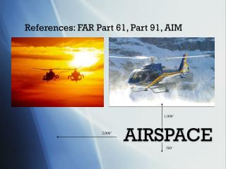
Nomenclature & Fine Points • “Ceiling” • The upper limit of an airspace • “Floor” • The lower limit of an airspace • Altitudes of airspace ceilings and floors are marked on the chart • Note carefully whether a boundary is “up to and including” or “up to but not including”
Abbreviations • MSL • Mean Sea Level • NOTAM • Notice To Airmen • SFC • Surface • SVFR • Special VFR • VFR • Visual Flight Rules • AGL • Above Ground Level • ATC • Air Traffic Control • DVFR • Defense Visual Flight Rules • FL • Flight Level • FSS • Flight Service Station • IFR • Instrument Flight Rules
Let’s learn the ABCs… • Airspace dimensions • Chart notations
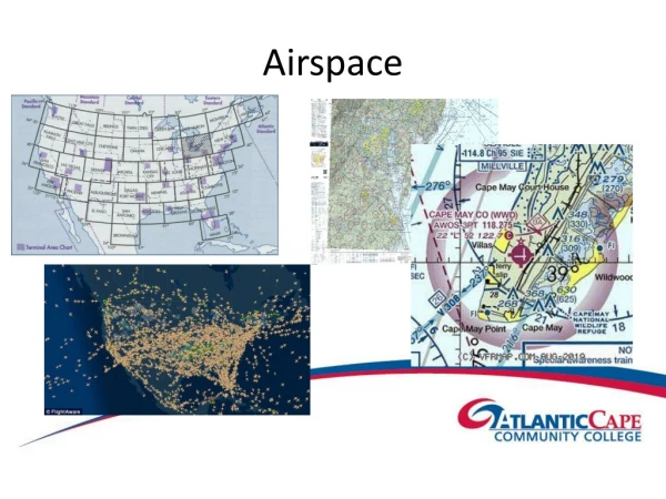
Chart Legend • Sectional Chart • Terminal Area Chart
Airspace Legend • Sectional Chart • Terminal Area Chart
Class Alpha Airspace • Generally, that airspace from 18,000 feet MSL up to and including FL 600 • Including the airspace overlying the waters within 12 nautical miles of the coast of the 48 contiguous States and Alaska • Including designated international airspace beyond 12 nautical miles of the coast of the 48 contiguous States and Alaska within areas of domestic radio navigational signal or ATC radar coverage, and within which domestic procedures are applied • Class A Airspace is not specifically charted Reference: AIM Chapter 3-2-2
Class A Airspace wouldn’t be shown on our low altitude charts anyway
Class Bravo Airspace • Generally, that airspace from the surface to 10,000 feet MSL surrounding the nation's busiest airports in terms of IFR operations or passenger enplanements • The configuration of each Class B airspace area is individually tailored and consists of a surface area and two or more layers (some Class B airspace areas resemble upside-down wedding cakes) • The Class B airspace is designed to contain all published instrument procedures once an aircraft enters the airspace Reference: AIM Chapter 3-2-3
Class B Airspace is denoted by a thick blue line • Class B airspace is charted on Sectional Charts, IFR Enroute Low Altitude, and Terminal Area Charts
Mode C Veil • The airspace within 30 nautical miles of an airport listed in Appendix D, Section 1 of FAR Part 91 (generally primary airports within Class B airspace areas), from the surface upward to 10,000 feet MSL • West Coast airports with Mode C Veils: • SFO • LAX • SAN • SEA • LAS • HNL Reference: AIM Chapter 3-2-3
Mode C Veil is denoted by a thin magenta line • Do not confuse this withClass C airspace!
Class Charlie Airspace • Generally, that airspace from the surface to 4,000 feet above the airport elevation (charted in MSL) surrounding those airports that: • Have an operational control tower • Are serviced by a radar approach control • Have a certain number of IFR operations or passenger enplanements • Although the configuration of each Class C airspace area is individually tailored, the airspace usually consists of: • A 5 NM radius core surface area [“Inner Circle”] that extends from the surface up to 4,000 feet above the airport elevation • A 10 NM radius shelf area [“Outer Circle”] that extends from 1,200 feet to 4,000 feet above the airport elevation • There are 11 Class C Airspace Areas in California Reference: AIM Chapter 3-2-4
Outer Area SurroundingClass Charlie Airspace • The normal radius will be 20 NM, with some variations based on site specific requirements • The outer area extends outward from the primary airport and extends from the lower limits of radar/radio coverage up to the ceiling of the approach control's delegated airspace, excluding the Class C airspace and other airspace as appropriate Reference: AIM Chapter 3-2-4
Class C Airspace is denoted by a thick magenta line on Sectional Charts, Enroute Charts, IFR Enroute Low Altitude, and Terminal Area Charts • The Outer Area is not specifically charted
Class Delta Airspace • Generally, that airspace from the surface to 2,500 feet above the airport elevation (charted in MSL) surrounding those airports that have an operational control tower • The configuration of each class D airspace area is individually tailored and when instrument procedures are published, the airspace will normally be designed to contain the procedures • Arrival extensions for instrument approach procedures may be Class D or Class E airspace • As a general rule, if all extensions are 2 miles or less, they remain part of the Class D surface area • However, if any one extension is greater than 2 miles, then all extensions become Class E. Reference: AIM Chapter 3-2-5
Class D Airspace is denoted by a blue segmented line • Ceilings of Class D (in hundreds of feet) are shown in a blue segmented box • Understand the minus sign!
Class Echo Airspace • Generally, if the airspace is not Class A, Class B, Class C, or Class D, and it is controlled airspace, it is Class E airspace • Except for 18,000 feet MSL, Class E airspace has no defined vertical limit but rather it extends upward from either the surface or a designated altitude to the overlying or adjacent controlled airspace Reference: AIM Chapter 3-2-6
Types of Class E Airspace • Surface area designated for an airport • When designated as a surface area for an airport, the airspace will be configured to contain all instrument procedures • Extension to a surface area • There are Class E airspace areas that serve as extensions to Class B, Class C, and Class D surface areas designated for an airport • Such airspace provides controlled airspace to contain standard instrument approach procedures without imposing a communications requirement on pilots operating under VFR • Airspace used for transition • There are Class E airspace areas beginning at either 700 or 1,200 feet AGL used to transition to/from the terminal or enroute environment • Enroute Domestic Areas • There are Class E airspace areas that extend upward from a specified altitude and are enroute domestic airspace areas that provide controlled airspace in those areas where there is a requirement to provide IFR enroute ATC services but the Federal airway system is inadequate. Reference: AIM Chapter 3-2-6
Types of Class E Airspace • Federal Airways • The Federal airways are Class E airspace areas and, unless otherwise specified, extend upward from 1,200 feet up to, but not including, 18,000 feet MSL • VOR airways are classified as Domestic, Alaskan, and Hawaiian • Based on VOR or VORTAC navigational aids • Identified by a V and the airway number • Commonly called “Victor Airways” • Colored airways are Green, Red, Amber, and Blue • Only a few left, in Alaska and coastal North Carolina • Based on Low/Medium Frequency navigational aids or NDBs • Designated with a color and a number Reference: AIM Chapter 3-2-6
Types of Class E Airspace • Offshore Airspace Areas • There are Class E airspace areas that extend upward from a specified altitude up to, but not including, 18,000 feet MSL and are designated as offshore airspace areas • These areas provide controlled airspace beyond 12 miles from the coast of the United States in those areas where there is a requirement to provide IFR enroute ATC services and within which the United States is applying domestic procedures • Unless designated at a lower altitude • Class E airspace begins at 14,500 feet MSL up to, but not including 18,000 feet MSL overlying: • The 48 contiguous States including the waters within 12 miles from the coast of the 48 contiguous States • The District of Columbia • Alaska, including the waters within 12 miles from the coast of Alaska, and that airspace above FL 600 • Excluding the Alaska peninsula west of longitude 160°00’00"W, and the airspace below 1,500 feet above the surface of the earth unless specially so designated Reference: AIM Chapter 3-2-6
Class E Airspace has 5 different chart symbols • Class E airspace below 14,500 feet MSL is charted on Sectional, Terminal, and IFR Enroute Low Altitude charts
Class Golf Airspace • Class G airspace (uncontrolled) is that portion of the airspace that has not been designated as Class A, Class B, Class C, Class D and Class E airspace • Class G airspace typically extends from the surface to the base of the overlying controlled airspace (Class E or other), which is normally 700 or 1,200 feet AGL • Example: SQL, PAO, & HWD become Class G when the tower is closed • In some areas Class G airspace may extend from the surface to 14,500 MSL • Exception: When 14,500 MSL is lower than 1,500 feet AGL, Class G airspace continues up to 1,500 feet above the surface Reference: AIM Chapter 3-3-1; Jeppesen Private Pilot Manual Chapter 4D
You can find Class G airspace on the hard side of the blue that denotesClass E Airspace • Check your AFD for airport terminal areas (typically Class D) that become Class G when the tower is closed
Overlapping Airspace • Often in busy terminal areas you will find airspaces stacked on top of each other • Locally we find Class C, D, & E airspace all stacked underneath Class B • Study your Terminal Area Chart carefully – before flying! • Pick out landmarks and VOR/DME navaids to help you identify complicated airspaces
Special Use Airspace • Prohibited Areas • Restricted Areas • Warning Areas • Alert Areas • Military Operations Areas • Controlled Firing Areas Reference: AIM Chapter 3-4
Special Use Airspace • Special use airspace consists of that airspace wherein activities must be confined because of their nature, or wherein limitations are imposed upon aircraft operations that are not a part of those activities, or both • Except for Controlled Firing Areas, special use airspace areas are depicted on aeronautical charts • Prohibited and Restricted Areas are regulatory special use airspace and are established in FAR Part 73 through the rule-making process • Warning Areas, Military Operations Areas (MOA), Alert Areas, National Security Areas (NSA), and Controlled Firing Areas (CFA) are nonregulatory special use airspace. • Special use airspace descriptions (except NSA's and CFA's) are contained in FAA Order 7400.8 • Special use airspace (except CFA's) are charted on IFR and Visual charts and include the hours of operation, altitudes, and the controlling agency Reference: AIM Chapter 3-4-1
Prohibited Areas • Prohibited Areas contain airspace of defined dimensions identified by an area on the surface of the earth within which the flight of aircraft is prohibited • Such areas are established for security or other reasons associated with the national welfare • These areas are published in the Federal Register and are depicted on aeronautical charts Reference: AIM Chapter 3-4-2
Restricted Areas • Restricted Areas contain airspace identified by an area on the surface of the earth within which the flight of aircraft, while not wholly prohibited, is subject to restrictions • Activities within these areas must be confined because of their nature or limitations imposed upon aircraft operations that are not a part of those activities or both • Restricted Areas denote the existence of unusual, often invisible, hazards to aircraft such as artillery firing, aerial gunnery, or guided missiles • Penetration of Restricted Areas without authorization from the using or controlling agency is illegal and may be extremely hazardous to the aircraft and its occupants • Restricted areas are published in the Federal Register and constitute 14 CFR Part 73. Reference: AIM Chapter 3-4-3
Warning Areas • A Warning Area is airspace of defined dimensions, extending from three nautical miles outward from the coast of the United States, that contains activity that may be hazardous to nonparticipating aircraft • The purpose of such warning areas is to warn nonparticipating pilots of the potential danger • A warning area may be located over domestic or international waters or both Reference: AIM Chapter 3-4-4
Alert Areas • Alert Areas are depicted on aeronautical charts to inform nonparticipating pilots of areas that may contain a high volume of pilot training or an unusual type of aerial activity • Pilots should be particularly alert when flying in these areas Reference: AIM Chapter 3-4-6
Prohibited, Restricted, Warning, and Alert Areas are depicted as enclosed blue boxes with blue lines • Look on the side of the chart for more info, including times of operations and controlling agency
Military Operations Areas • MOA's consist of airspace of defined vertical and lateral limits established for the purpose of separating certain military training activities from IFR traffic. • Whenever a MOA is being used, nonparticipating IFR traffic may be cleared through a MOA if IFR separation can be provided by ATC. Otherwise, ATC will reroute or restrict nonparticipating IFR traffic. • Most training activities necessitate acrobatic or abrupt flight maneuvers. Military pilots conducting flight in Department of Defense aircraft within a designated and active military operations area (MOA) are exempted from the provisions of FAR Part 91.303(c) and (d) which prohibit acrobatic flight within Federal airways and Class B, Class C, Class D, and Class E surface areas. Reference: AIM Chapter 3-4-5