Download
1 / 31
320 likes | 557 Views
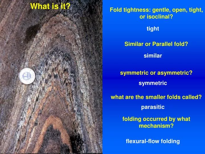
What is it?. Fold tightness: gentle, open, tight, or isoclinal?. tight. Similar or Parallel fold?. similar. symmetric or asymmetric?. symmetric. what are the smaller folds called?. parasitic. folding occurred by what mechanism?. flexural-flow folding. Announcements:

E N D
What is it? Fold tightness: gentle, open, tight, or isoclinal? tight Similar or Parallel fold? similar symmetric or asymmetric? symmetric what are the smaller folds called? parasitic folding occurred by what mechanism? flexural-flow folding
Announcements: Field Trip NEXT Saturday = February 7
Techniques for projecting and plotting structural data D&R, p. 684-716
2 measurements are needed to define orientation of structures:(1) Compass direction (azimuth) in horizontal plane(2) Angle down from horizontal IN A VERTICAL PLANE Linear features:trend and plungePlanar features: strike and dipConventions: Quadrant; Right-hand-rule
Stereographic projectionplotting 3D structural data onto a hemisphere (usually the lower), which is projected onto a horizontal plane
All lines and planes are imagined to pass through the center of the hemisphere Lines intersect the lower hemisphere as points. Shallow lines plot near the perimeter Steep lines plot near the center Let's plot the following lines: (1) trend = 60; plunge = 70 (2) trend = 340; plunge = 10
Planes intersect the lower hemisphere in the form of great circles. • Let's plot the following planes: (1) strike = N-S, dip = 90 (2) strike = 30, dip = 60 (3) strike = 120, dip = 10
A plane can also be represented by its pole, which is a line perpendicular to the plane. Let's plot the pole of the following plane: (1) strike = 340, dip = 60
Plotting strike and dip of plane and trend and plunge of lineation Strike = N40W, dip = 30 SW Trend = S22W, plunge = 28
Rake =Just another way of measuring orientation of line in plane! = The acute angle between horizontal (strike line) and line in plane, MEASURED IN THE PLANE BY PROTRACTOR; must specify direction: e.g., Rakes from NW vs. SE? When/why do we measure rake? Let’s plot plane and line (given rake) What is trend and plunge of line? Why do this?
Orthographic projection:2D line drawings that are used to determine angular and spatial relationships in 3D
project surface data to depth plot points along bed at various depths project points vertically to surface make structure contour map Constructing structure contour maps
Structure contour maps are basically just “topographic” maps of geologic surfaces
Determining the true thickness of a bed from a geologic map 1. Draw a X-section perpendicular to strike2. Plot the true dip of the beds and project them to depth3. Use trigonometry to calculate the true thickness map distance sin(dip) = true thickness/map thickness true For a dipping bed, the map-view thickness is an "apparent" as opposed to "true" thickness!
Determining strike and dip from geologic maps Strike = connect line between 2 points of equal elevation along contact Dip = define another strike line at a different elevation; trigonometry 75 m strike at 1600 m strike at 1620 m 75 m 20 m tan(dip) = elevation change / map distance
Cottonwood FT prep • Goal 1: learn how to produce a simple geo map -identify units, accurately presenting them on a topo map; • Goal 2: identify structures and place them on maps; • Goal 3: measure orientation of structures (planes,lines) in the field; • Goal 4: make a cross section depicting the geometry of the surface geology at depth; • Goal 5: have fun!!!!
Units • Precambrian granite • Precambrian dike • Miocene conglomerate • Quaternary alluvium
Structures • Primary intrusive • Primary depositional • Primary unconformity? • Bedding • Faulting
Hypothesis and interpretation • Geologic history - what happened when • Architecture • Cross section - decide how to build • Make cross section • Applications if any
Next Lecture: Joints, fractures Reading: D & R Ch 5