Download
1 / 7
70 likes | 206 Views
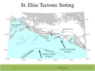
St. Elias Tectonic Setting. Introduction Data Collection and Processing Modeling Southeast Alaska St. Elias Orogen Summary Northern Pacific. STEEP GPS Velocity Field. #1. #2. #3.

E N D
St. Elias Tectonic Setting Introduction Data Collection and Processing Modeling Southeast Alaska St. Elias OrogenSummary Northern Pacific
STEEP GPS Velocity Field #1 #2 #3 GPS velocity field across Eastern Prince William Sound and Chugah/St. Elias region. Velocities are relative to North America. There are several segments within the velocity field. Segment #1: Strong gradient in velocities from south to north. Segment #2: Velocities become larger and are more uniform. Segment #3: Velocities are pretty uniform, but smaller than in the second segment.
Block Model Fault Geometry A’ A Best-fit fault geometry. The only way I could fit the variable velocity field was to have different tectonic regimes in the east and west. In the east, there are crustal thrust faults that sole out into a mostly creeping Yakutat decollement. In the west, there is a broad, locked subuction interface between the Yakutat block and the upper blocks (see next slide). There are pop up diagrams that will come up when you click again.
Predicted Linear Block Velocities Using the fault geometry and the GPS data as my inputs, I performed an inversion to solve for the velocities of the blocks making up the upper plate. The best-fit configuration required several small blocks. The vectors show the predicted block velocities. What I’m calling the Elias block may actually have additional divisions (see red dashed lines). Those boundaries are not well resolved and likely have very little motion. Note the westward rotation of the Elias block towards the Aleutian forearc.
Predicted Relative Block Motions I calculated the relative motions between the blocks shown in the previous slide. Relative motion is not quite the same as slip rate since slip rate depends on the fault geometry and relative block motion does not. For the crustal faults, the relative motion is between neighboring upper plate blocks. For the subsurface/gray faults (subduction interfaces), the relative motion is between the upper plate blocks and the Yakutat block. These values are the full relative motion rates and do not taking the coupling on each fault plane into account. The next slide does.
Same as the last slide, expect numbers now take the coupling into account. The subduction interface beneath the Chugach seems to be almost fully locked. The regions around Kayak Island and Cordova are only partly locked (resulting in the smaller GPS velocities relative to the velocities to the east). The area under Valdez (and near the 1964 epicenter) appears to be fully locked. These numbers are still the relative blocks, not true slip rates. I can calculate slip rates pretty quickly if you need them. Green dots show the location of the GPS sites whose velocities are shown earlier.
Major Points • The locked subduction interface between the Yakutat block and the upper plate begins around the Bering Glacier, perhaps even a bit east of the Bering Glacier. • The upper plate is made up of multiple small, rotating blocks. The most western upper block appears to be rotating out along the Aleutian forearc • The subduction interface in eastern Prince William Sound is between the Yakutat block and the upper plate, not Pacific plate and North America. • The subduction interface has variable degrees of locking, with the highest locking under the Chugach Mountains and Valdez. The region around Kayak Island and Cordova has lower locking.