Download
1 / 25
250 likes | 421 Views
Challenges in Representing a Multifaceted World in Multiple Representations. Robert Weibel GIS Division Department of Geography University of Zurich Dagstuhl, 6-10 March 2006. Objective.

E N D
Challenges in Representing a Multifaceted World in Multiple Representations Robert Weibel GIS Division Department of Geography University of Zurich Dagstuhl, 6-10 March 2006
Objective I want to discuss the limitations of current multiple representations and possible ways to overcome these. Content 1. What are today’s MRs? 2. What could MRs be? 3. How could we deal with that? -- Open problems!
1 What are today’s multiple representations?
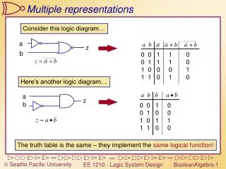
Multiple Representations (MR) Detailed topo map 1:2,500 Swisstopo Natl. Map 1:25,000 Swisstopo Natl. Map 1:200,000 MRDB: Spatial DB in which the same real-world phenomena are represented in different ways, at different scales/resolutions, and with different levels of accuracy. Multiple reps of the same real-world objects should be explicitly linked.
Terminology • Multiple representation = generic term for • multi-scale • multi-resolution • multi-structured
Genius-DB MRDB Dataflow (Swisstopo) TopGIS-CH DLM1M DCM 1M DCM 500 DLM200 DCM 200 DCM 100 Data capture Integration Verification DCM 50 DCM 25 TLM Source: Novit Kreiter, Swisstopo, 2003
Swisstopo road data 1:25k and 1:200k Matching of Different Scales Lüscher (2006)
Realtime Cartography (Web, PDA): Drilling Incremental updating and generalization ‘Interpolating‘ generalization: Morphing Realtime cartography (Web, PDA): Drilling Lüscher (2006) Lüscher (2006) Cecconi (2003) Bobzien et al. (2006) example after Baumgartner (1990) What are MRDBs good for? • Checking & improving consistency of multiscale DBs • Updating of (multiscale) databases (incremental genln) • New opportunities for data use: • ... and many more applications: • vehicle navigation (city, countryside) • fusion of data sources • checking/improving data quality
MRDBs today • Are almost exclusively concentrating on topographic applications (plus navigation). • Are focusing on an entity concept (rather than fields). • Are limited to representing crisp objects. • Are limited to vector data structures. • Are limited to fixed levels of scale/detail (LOD). • Are limited to the representations of static objects. • That is, they miss out on a lot of aspects that are part of our understanding of the world.
2 What could MRs be?
‘Multi’ can mean many things … • Multi-scale … cartographic scale vs. process scale • Multi-delineation … crisp vs. fuzzy objects • Multi-georeferencing … coordinates vs. ‘named places’ (ie. space vs. place) • Multi-theme … possibly involving semantic ambiguities • Multi-lingual … important in an international context (and also in countries with multiple languages) • Multi-temporal … the world isn’t static. • I will look in more detail at: • representing cartographic scale vs. process scale • representing fuzzy named places space theme time
Cartographic Scale vs. Process Scale • Dichotomy of form vs. process • Form may give hints on the genesis (ie. process) • Every process has its scale range. Forms may look similar at different scales, but the processes are different.
Process Scale • Continuous processes • Continuum of process scales • Can this be represented using entities / objects? • Rather not. Needs fields. • Problem: Because existing MRDBs take an essentially cartoographic approach, they are restricted to representing form not process. http://www.cru.uea.ac.uk/cru/info/modelcc/
Fuzzy Named Places • Imprecise regions imprecisely defined in linguistic terms • Frequent in everyday use • Example: ‘Mittelland’ in Switzerland • Others: British ‘Midlands’, ‘Bible Belt’, ‘Hunsrück’ etc. Density surface derived from locations named by students for the term ‘Mittelland’
Delineating Imprecise Regions by Mining Web Documents • Find web pages that contain the term (e.g. ‚Scotish Highlands‘) Google API • Geoparse and geocode the locations of these candidates (by means of a gazetteer) • Generate a density surface, representing the imprecise region and extract a boundary (by thresholding) • Part of SPIRIT project ‚Highlands of Scotland‘ Purves et al. (2004, 2005)
3 How could we deal with that?(Open problems)
Questions • Are MRDBs the wrong approach? (I.e. should we get rid of them?) • not really — MRDBs have been shown to be useful for a variety of purposes • also: the multi-scale nature of many real-world phenomena makes MRDBs interesting by definition • How can we represent uncertainty and process in MRDBs? (I.e. how can we go beyond representing static, crisp objects?) • storing vs. computing information • explicit vs. implicit representation • if storage is used, what is stored and how is it stored?
Process & Uncertainty: Storing vs. Computing • Options: • explicit representation: store all states as well as links between them • implicit representation: store initial state and generating process (e.g. as stored procedure) • or mixed versions • In implicit representation, the links are substituted by procedures • Other things to consider • computing can be simpler and more efficient than storing nobody stores coordinates in different projections • computing multiple representations is more flexible • However: It must be possible to formalize the generating process and cast it into a procedure.
Exploiting Links: Morphing • Store: 1) links btw several LODs; 2) procedure to interpolate btw LODs • Explicit representation of several LODs • But: Possibility to reduce/minimize the number of LODs Diss Cecconi (2003)
multi-resolution representation1 multi-resolution representation2 Compression Compression Compression coarser level model upgrade 1 upgrade 2 Decompression Decompression Decompression reconstruction reconstruction Progressive Vector Transmission • Implicit representation: Only initial (high-res) state stored • Other states/LODs are derived by computation Yang, Purves & Weibel (2004, 2006)
Representing Imprecise Regions • What should be stored? • document footprints (points)? density surface (polynomial fct)? density slices (polygons)? the extraction procedure? ‚Highlands of Scotland‘
Little or no potential for MRDBs • Probably too complex for GIS & DB no benefits accrue • Process is represented in PDEs of GCMs, RGMs, and meso-/microscale models • Upscaling/downscaling of parameters in between • (This is maybe where GIS could help.) http://www.cru.uea.ac.uk/cru/info/modelcc/
Summary • Tried to show the limitations of existing approaches to MR modeling in MRDBs, which are: • focus on topographic (mapping) applications • hence focusing on crisp, static objects; fixed scales • What’s mainly missing from existing MR approaches: • ways to represent process • ways to represent imprecision (as a result of process) • Discussed options for representing process and imprecision • explicit vs. implicit representation
Conclusions • Hypothesis underlying my talk: It’s worth extending MR approaches, as they could be useful for applications other than topographic mapping and navigation • Still, plenty of open problems. • Research needs: • develop theory of process representation in GIScience (physics has that already) • possible starting point: • categorize application domains w.r.t. their potential/requirements for process rep • categorize different types of processes against different representations options (explicit, implicit)