Download
1 / 23
230 likes | 236 Views
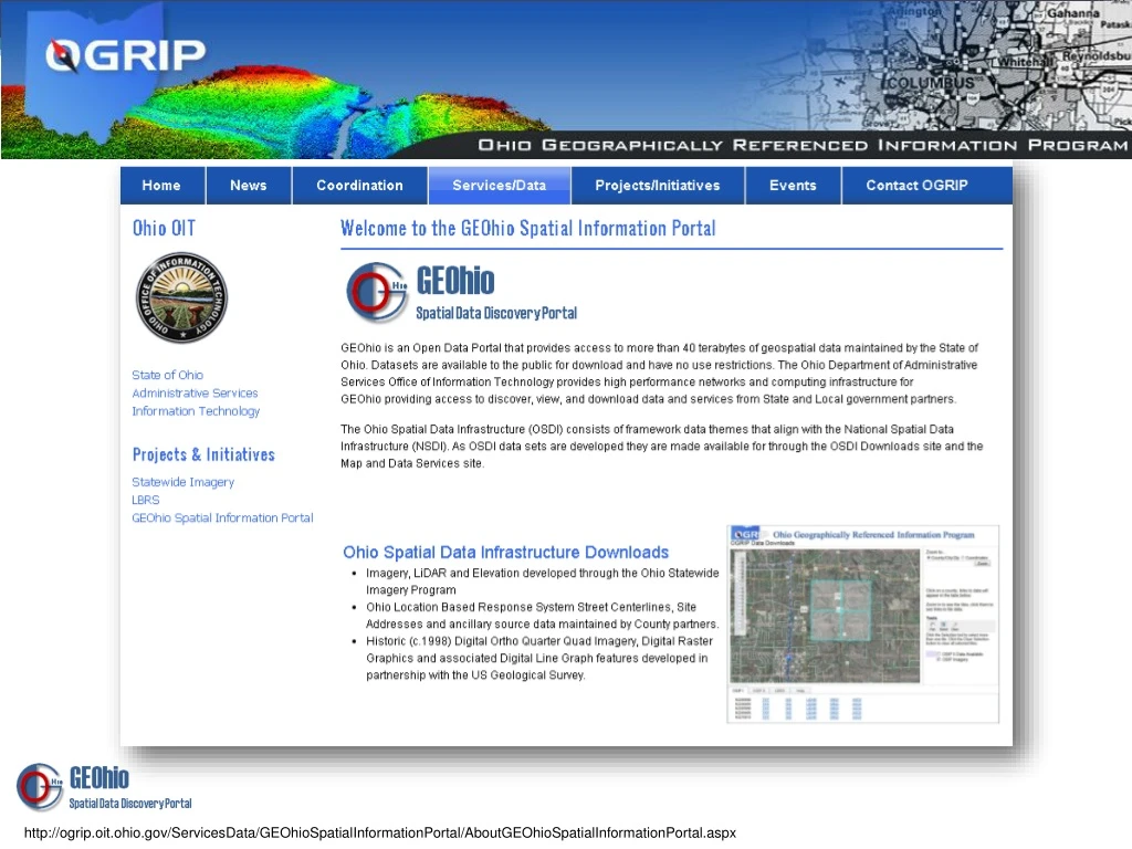
The GEOhio Spatial Information Portal provides access to geospatial data and tools for data discovery and distribution in Ohio. It includes imagery, LiDAR, street centerlines, site addresses, and more.

E N D
http://ogrip.oit.ohio.gov/ServicesData/GEOhioSpatialInformationPortal/AboutGEOhioSpatialInformationPortal.aspxhttp://ogrip.oit.ohio.gov/ServicesData/GEOhioSpatialInformationPortal/AboutGEOhioSpatialInformationPortal.aspx
Geospatial Data Discovery & Distribution OGRIP Data Downloads Imagery, LiDAR and Elevation developed through the Ohio Statewide Imagery Program Ohio Location Based Response System Street Centerlines, Site Addresses and ancillary source data maintained by County partners. Historic (c.1998) Digital Ortho Quarter Quad Imagery, Digital Raster Graphics and associated Digital Line Graph features developed in partnership with the US Geological Survey. http://gis5.oit.ohio.gov/geodatadownload
Geospatial Data Discovery & Distribution REST Service Endpoints The GEOhio Spatial Information Portal provides REST services to support desktop mapping and GIS applications. Data hosted on GEOhio is developed and maintained by State and local government supporting enterprise level applications developed for the State of Ohio http://ogrip.oit.ohio.gov/ServicesData/GEOhioSpatialInformationPortal/RESTServiceEndpoints.aspx
Geospatial Data Discovery & Distribution GIS Resource Links The GEOhio Map and Data Services portal is maintained by OGRIP to provide access to Ohio's Spatial Data Infrastructure in the form of hosted map, image, and feature services, a customizable map interface, as well as links to State and Local Government mapping resources and spatial data download applications. http://geohio.maps.arcgis.com/
Geospatial Data Discovery & Distribution Open Data Search Tool Providing access to geospatial data maintained by State and Local Government the GEOhio Spatial Information Portal provides data discovery and access tools to search for spatial information using keywords or a map interface and the ability to download vector data in multiple file formats. http://ogrip.geohio.opendata.arcgis.com/
http://gis5.oit.ohio.gov/ArcGIS/services http://ogrip.oit.ohio.gov Jennifer McFarland 614.644.0635 Jennifer.McFarland@das.ohio.gov
State • State Of Ohio • OGRIP • Website: http://ogrip.oit.ohio.gov/ • Open Data Group Name: OGRIP Open Data • REST Services: • http://ogrip.oit.ohio.gov/ServicesData/GEOhioSpatialInformationPortal/RESTServiceEndpoints.aspx • Data Downloads: • http://ogrip.oit.ohio.gov/ServicesData/GEOhioSpatialInformationPortal/OhioSpatialDataInfrastructureDownloads.aspx • Contacts: • Jeff Smith • GIS Administrator • 77 S High St 19thFlr • Columbus OH 43215 • 614-466-8862 • Jeff.smith@ohio.gov • Jennifer McFarland • Jennifer.McFarland@das.ohio.gov • ODOT • Website: http://gis.dot.state.oh.us/tims • Downloads: http://gis.dot.state.oh.us/tims/Data/Download • Contacts: • Dave Blackstone • GIS Manager • 1980 W Broad St • Columbus, OH • ODNR • Website: http://www2.ohiodnr.gov/geospatial/map-services County MPO City Other GEOhio Spatial Data Discovery Portal
Geospatial Data Development Ohio Statewide Imagery Program - OSIP OSIP is a partnership between Local, State and Federal government agencies to develop high-resolution imagery and elevation data to benefit GIS users at all levels of government. http://ogrip.oit.ohio.gov/ProjectsInitiatives/StatewideImagery.aspx
Geospatial Data Development Ohio Location Based Response System LBRS SUPORTING PUBLIC SAFETYEMERGENCY RESPONSEROADWAY INVENTORYCRASH ANALYSISNEXT GENERATION 9-1-1CENSUS ENUMERATION http://ogrip.oit.ohio.gov/ProjectsInitiatives/LBRS.aspx
Geospatial Data Development Address Maintenance Tool • The Address Data Maintenance Tool is an ArcMap • Add-in that provides geometric and attribute editing capabilities for Address layers to: • Map dissimilar field names between points and centerlines • Copy shared attributes from a road centerline to an address point • Estimate a house number for new address points • Search street and address records • While the tool was developed to work with the State’s LBRS data it can be used to maintain address points using any transportation centerline data.
GIS CONSIDERATIONS FOR • NG9-1-1 IMPLEMENTATION • NG9-1-1 requires the development of new capabilities and workflows for GIS professionals to support the provisioning of spatial information from a GIS to the NG9-1-1 system. • Cooperative agreements and partnerships must be established to engage and clearly define roles and responsibilities ofPSAP Managers, Local Addressing Authorities, Street Authorities, Telephone Service Providers, GIS Professionals and NG9-1-1 Service Providers. • A clearly defined process for handling discrepancy reports and the timely processing data corrections by GIS Professionals to the NG9-1-1 system must be implemented. • Local NG9-1-1 implementations • must coordinate with neighboring • jurisdictions to ensure there are no • gaps or overlaps in geospatial • coverage that would result in • missed or miss-routed calls. • NG9-1-1 cannot exist without a commitment to GIS data development, • maintenance, and management at the state and local level. RESPONSE ZONES & BOUNDARIES
GIS CONSIDERATIONS FOR • NG9-1-1 IMPLEMENTATION • Questions to establish the readiness of a GIS to support spatial call routing: • Does your jurisdiction track annexations and dissolutions spatially? • Are they accurately reflected in your PSAP boundaries and Emergency response zones? • Are effective dates tracked so the ECRF can continue to route calls until there is an automatic cutover to the jurisdiction? • Do you track and maintain mutual aid agreements spatially along with their associated effective dates? • Have you corrected gaps or overlaps in coverage between your ESZs and those of your neighboring PSAPs? • Is there a data governance agreement in place and a procedure for conflict resolution between jurisdictions? • Have you synchronized the ALI with your GIS addresses? • Is there a maintenance plan or process in place for nightly Service Order Interface record updates from the telco(s)? • Has your street centerline been reconciled with your MSAG? • Is there a defined maintenance process? • If the answer to any of these • questions is no, then there • might be some work to do • before firing up an ECRF. • This is a different discussion from tactical • mapping and turn-by-turn routing requirements. RESPONSE ZONES & BOUNDARIES
Federal Activities Addresses National Address Database Summit National Address Database (NAD) Census Geographic Support System Initiative (GSS-I) National Emergency Address Database (NEAD) Transportation (MAP21/ARNOLD) 3D Elevation Program (3DEP) Geospatial Data Act (GDA) National Hydrography Dataset (NHD)
OHIO GIS Best Practices Award Presented to organizations implementing GIS in a manner consistent with OGRIP’s stated goals and Objectives by: • Demonstrating an enterprise-wide approach and community resource perspective. • Supporting and facilitating data sharing through an increase in interaction between entities. • Demonstrating the use of GIS as an analysis and decision support tool. Demonstrates the integration of GIS and spatial data into daily operations of the program. Demonstrates consistency with the NSDI Framework. 2015 Ohio GIS Conference September 21 - 23, 2015 | Hyatt Regency Columbus| Columbus, Ohio
OHIO GIS Best Practices Award Stark County GIS Department Countywide GIS Repository and Collaboration Alan Arnold, Auditor Brian Hall, GIS Director Joe Guzi John Reese Danielle Papineau 2015 Ohio GIS Conference September 21 - 23, 2015 | Hyatt Regency Columbus| Columbus, Ohio
OHIO GIS Best Practices Award County of Summit GIS Russell M. Pry, County Executive Dennis Tubbs, Deputy Director Planning & GIS Ryan Sellman Stephen Knittel Karla Streharsky Susan DeChant Andrew Chatterton Kirk DeGroff 2015 Ohio GIS Conference September 21 - 23, 2015 | Hyatt Regency Columbus| Columbus, Ohio
Cliff Lovin Scholarship Award Presented by Jeff Lovin Kyle Parker 2015 Ohio GIS Conference September 21 - 23, 2015 | Hyatt Regency Columbus| Columbus, Ohio
URISA Leadership Service Award Presented by Tom Fisher Brett Alphin Emily Whitehead 2015 Ohio GIS Conference September 21 - 23, 2015 | Hyatt Regency Columbus| Columbus, Ohio
Ohio GIS Map Gallery Presented by Sean Phillips Reference Analytical Best of Show Peoples Choice 2015 Ohio GIS Conference September 21 - 23, 2015 | Hyatt Regency Columbus| Columbus, Ohio
Platinum Sponsor 2015 Ohio GIS Conference September 21 - 23, 2015 | Hyatt Regency Columbus| Columbus, Ohio
Silver Sponsors 2015 Ohio GIS Conference September 21 - 23, 2015 | Hyatt Regency Columbus| Columbus, Ohio
Vendors Bruce Harris & Associates, Inc. Cannon IV, Inc. City Blueprint of Toledo, Inc. Data Transfer Solutions, LLC E-Ring, Inc. Esri GeoCue Group GeoShack Hexagon Geospatial Pix 4D Precision Laser & Instrument, Inc. Resource International, Inc. Sidwell Stantec Surdex Corporation Transmap Corporation Utility Technologies, LLC Woolpert, Inc. Infogroup KE McCartney & Associates Kucera International, Inc. Latitude Geographics Lucity, Inc. MasterMind, LLC Nokia Ohio URISA Pictometry Visit the Vendor Trade Show in the Franklin Room 2015 Ohio GIS Conference September 21 - 23, 2015 | Hyatt Regency Columbus| Columbus, Ohio