Download
1 / 18
180 likes | 295 Views
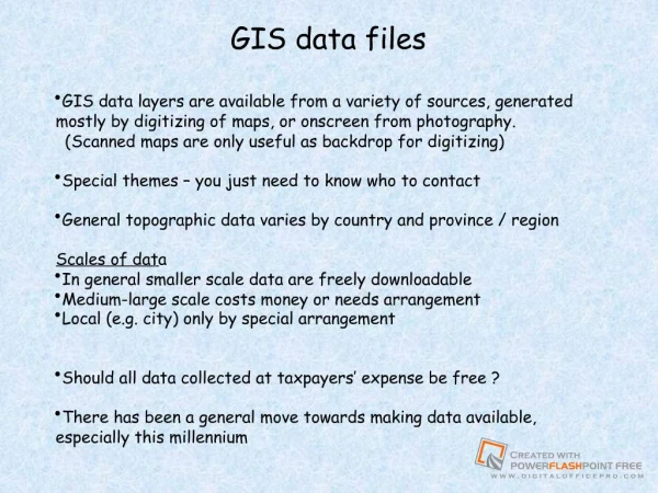
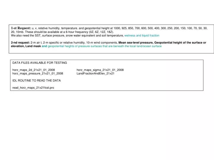
1-st Request: u, v, relative humidity, temperature , and geopotential height at 1000, 925, 850, 700, 600, 500, 400, 300, 250, 200, 150, 100, 70, 50, 30, 20, 10mb. These should be available at a 6-hour frequency (0Z, 6Z, 12Z, 18Z).

E N D
1-st Request: u, v, relative humidity, temperature, and geopotential height at 1000, 925, 850, 700, 600, 500, 400, 300, 250, 200, 150, 100, 70, 50, 30, 20, 10mb. These should be available at a 6-hour frequency (0Z, 6Z, 12Z, 18Z). We also need the SST, surface pressure, snow water equivalentand soil temperature, wetness and liquid fraction 2-nd request:2-m air t, 2-m specific or relative humidity, 10-m wind components, Mean sea-level pressure, Geopotential height of the surface or elevation, Land mask and geopotential heights of pressure surfaces that are beneath the local land/ocean surface DATA FILES AVAILABLE FOR TESTING horz_maps_2d_21x21_01_2008 horz_maps_sigma_21x21_01_2008 horz_maps_pressure_21x21_01_2008 LandFractionAndElev_21x21 IDL ROUTINE TO READ THE DATA read_horz_maps_21x21fcst.pro
DATA FORMATS horz_maps_2d_21x21.ctl : UNDEF -.999000E+03 OPTIONS SEQUENTIAL OPTIONS BIG_ENDIAN OPTIONS TEMPLATE TITLE UN-NAMED * XDEF 21 LINEAR -100.0 2.5 YDEF 21 LINEAR 20.0 2.0 ZDEF 0 LINEAR 1 1 TDEF 31*4 LINEAR 1JAN2008 6H * VARS 5 HEADER 0 99 HEADER GTM 0 99 SURFACE TEMPERATURE (K) PSF 0 99 SURFACE PRESSURE (MB) SNWD 0 99 SNOW DEPTH (MM) (ZERO OVER NONLAND) TDSL 0 99 DEEP SOIL TEMPERATURE (K) (ZERO OVER NONLAND) ENDVARS horz_maps_press_21x21.ctl : UNDEF -.999000E+03 OPTIONS SEQUENTIAL OPTIONS BIG_ENDIAN OPTIONS TEMPLATE TITLE UN-NAMED * XDEF 21 LINEAR -100.0 2.5 YDEF 21 LINEAR 20.0 2.0 TDEF 31*4 LINEAR 1JAN2008 6H * VARS 7 HEADER 0 99 HEADER U 17 99 U (M/S) V 17 99 V (M/S) T 17 99 T (K) PHI 17 99 PHI (M2/S2) Q 17 99 SPECIFIC HUMIDITY (KG/KG) SLP 0 99 SEA LEVEL PRESSURE (MB) ENDVARS horz_maps_sigma_21x21.ctl : UNDEF -.999000E+03 OPTIONS SEQUENTIAL OPTIONS BIG_ENDIAN OPTIONS TEMPLATE TITLE UN-NAMED * XDEF 21 LINEAR -100.0 2.5 YDEF 21 LINEAR 20.0 2.0 ZDEF 0 LINEAR 1 1 TDEF 31*4 LINEAR 1JAN2008 6h * VARS 5 HEADER 0 99 HEADER U10M 0 99 10 M U (M/S) V10M 0 99 10 M V (M/S) T2M 0 99 2 M T (K) Q2M 0 99 2 M Q (KG/KG) ENDVARS LandFractionAndElevation_21x21.ctl : UNDEF -.999000E+03 OPTIONS SEQUENTIAL OPTIONS BIG_ENDIAN OPTIONS TEMPLATE TITLE UN-NAMED * XDEF 21 LINEAR -100.0 2.5 YDEF 21 LINEAR 20.0 2.0 * VARS 3 HEADER 0 99 HEADER U 0 99 LAND FRACTION V 0 99 GEOPOTENTIAL HEIGHT (M2/S2) ENDVARS
ADDITIONAL DATA INFORMATION The ’read_horz_maps_21x21.pro' IDL routine can be used to read the forecast horz_maps_*21x21* data files. EXAMPLE 1 reading 5.56 a.m. 2M specific humidity field of file horz_maps_sigma_21x21_01_2008: IDL> im=21 & jm=21 & km=1 & nvars=5 & igrp_plot=3 IDL> ilvl=0 & itime=0 & iday=0 & smon=1 & syear=2008 IDL> histdir='/coupled/jmarshak/exp001CBay/24084/ens0/horz_maps_sigma_21x21_' IDL> tag='' & suppress=1 IDL> field_sub=fltarr(21,21) & header=fltarr(21,21) IDL> READ_HORZ_MAPS_21x21,im,jm,km,nvars,igrp_plot,ilvl, $ IDL> itime,iday,smon,syear,$ IDL> histdir,tag,field_sub,suppress=suppress,header=header IDL> print,'NEW HEADER ',header(0:20,0) NEW HEADER 2008.00 1.00000 1.00000 5.00000 56.0000 40.0000 18.0000 1.00000 21.0000 21.0000 0.00000 -100.000 20.0000 2.50000 2.00000 1.00000 2.00000 0.00000 -999.000 1.00000 0.00000 IDL> print,'MAX,MIN',igrp_plot,max(field_sub(where(field_sub gt -999.000))), $ IDL> min(field_sub(where(field_sub gt -999.000))) MAX,MIN 3 0.0177466 0.000160506 IDL> EXAMPLE 2 reading the land fraction and elevation data file ‘LandFractionAndElev_21x21’ using IDL: IDL> IDL> print,im,jm 21 21 IDL> header_s=fltarr(im ,jm ) & land_s=fltarr(im ,jm ) & elev_s=fltarr(im ,jm ) IDL> openr,2,'/coupled/jmarshak/exp001CBay/LandFractionAndElev_21x21',/swap_endian IDL> readu,2,d, header_s ,d IDL> print,'Header 21x21 :', header_s(0:14,0) Header 21x21 : 0.00000 0.00000 0.00000 0.00000 0.00000 0.00000 0.00000 0.00000 21.0000 21.0000 0.00000 -100.000 20.0000 2.50000 2.00000 IDL> readu,2,d, land_s,d IDL> readu,2,d, elev_s,d IDL> close,2 IDL>