Download
1 / 22
240 likes | 351 Views
U.S. Integrated Earth Observation System. Vice Admiral Conrad C. Lautenbacher, Jr., U.S. Navy (Ret.) Under Secretary of Commerce for Oceans & Atmosphere/NOAA Forum on Earth Observations September 20, 2004. Presentation Outline. Global Framework

E N D
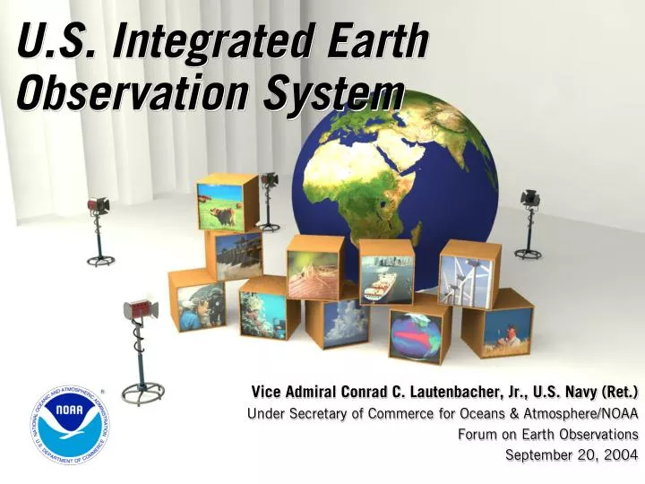
U.S. Integrated Earth Observation System Vice Admiral Conrad C. Lautenbacher, Jr., U.S. Navy (Ret.) Under Secretary of Commerce for Oceans & Atmosphere/NOAA Forum on Earth Observations September 20, 2004
Presentation Outline • Global Framework • U.S. Contribution to Global Earth Observation System of Systems • Societal Benefits • Implementation and Integration • Next Steps
The Global Framework • A distributed system of systems • Improves coordination of strategies and observation systems • Links all platforms: in situ, aircraft, and satellite networks • Identifies gaps in our global capacity • Facilitates exchange of data and information • Improves decision-makers’ abilities to address pressing policy issues
U.S. Contribution to GEOSS • VISION • Enable a healthy public, economy, and planet through an integrated, comprehensive, and sustained Earth observation system.
Benefits Focus Ecosystems Water Resources Natural & Human Induced Disasters Energy Resources Sustainable Agriculture & Desertification Human Health & Well-Being Oceans Weather Information, Forecasting & Warning Climate Variability & Change
Implementation Approach • Interface With User Community • Collect Earth Observations • Manage Data • Sustain Capacity • Deliver Information
Implementation Aspects • Policy and Planning • Data Sharing • Critical Observations • Technical • Interoperability • Data Management • Fiscal
U.S. Governance Structure • OSTP/OMB guidance memo June 6, 2003 • Earth Observation Subcommittee • Coordinated Interagency Approach Imperative
Integration • Policy and Planning Integration • Focus on specific societal benefits • Issue and Problem Focused Integration • Address a particular issue • Scientific Integration • Modeling of Earth processes • Technical Systems Integration • Coordination of observing system technology and data management systems • Account for observing system evolution
Architecture • Supports a range of implementation options • Addresses planned, research and operational systems • Capabilities interfaced through interoperability specifications • Inclusion of metadata and quality indicators • Continuity of observations, and instigation of new observations • Builds on existing systems and historical data • Federal Enterprise Architecture Framework
Next Steps:Near Term Opportunities • Data Management System for Earth Observations • Improved Observations for Disaster Warnings • Global Land Observing System • Sea Level Observing System • National Integrated Drought Information System • Air Quality Assessment and Forecast System
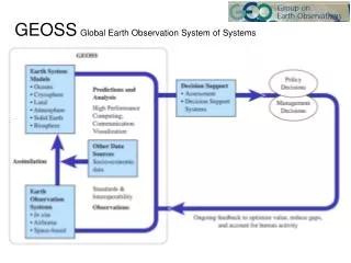
Data Management System for Earth Observations • Data Management Needs • New Systems mean 100-fold increase in data • Current systems already challenged • Development of browser and visualization systems • Interoperability through protocols and standards Example: Integrated Ocean Observing System
Improved Observations for Disaster Warnings • Improved Monitoring = Improved Forecasting • Need for systematic, widespread coverage
Global Land Observing System • Support Land Management Decisions • Extent of Urban Sprawl • Land Cover Impact on Water Quality • Characterization of Biodiversity, Agricultural Production, Forest, and Vegetation Health
Sea Level Observing System • Key Climate Variable • 100 million people live within 1 meter of sea level • Global sea rise statistics range from 9-88 centimeters • Discussion point of G8 • Socio-Economic Implications for the Arctic • Alaskan villages susceptible to erosion and flooding • Estimated cost of relocation ~$1billion
National Integrated Drought Information System (NIDIS) • Key Components • Integrated National Drought Monitoring & Forecasting System • Multi-agency collaboration; NOAA lead • Facilitates information exchange between local, state and federal agencies • Proactive, Not Passive, Drought Response • Improve Drought Indicator Data/Networks (Physical, Hydrological, Socio-Economic, Impacts) • Integrate & Interpret that Data with Easily Accessible & Understandable Tools • Supported by Western Governors 16
Air Quality Assessment and Forecast System • Key Understandings • Growth in populations, energy consumption and economy • 100 million people live in U.S. counties that exceed National Ambient Air Quality Standards • Poor air quality harmful to health of adults and children
The Road Ahead • Continue to engage academic, industry, and non-profit partners to guarantee plan comprehensive and useful • Public comments and November 2004 workshop • Industry alliance has been formed • Update draft; e.g., incorporate public comments and November 2004 workshop outputs • Deliver final draft to international GEO process
Private Sector • Acquire and use Earth observations • The private sector represents major providers, enablers, and consumers of Earth observation and environmental information • Integrated Observation system will encompass needs of private sector • Economic Impacts • National institutes which provide weather, climate, public health, and water services contribute $20-40 billion to economy • Weather and Climate sensitive industries account for up to 1/3 of nation’s GDP $2.7 trillion • System of Systems • Opportunities for development of new and existing Earth observation systems
Earth Observation Information • Strategic Plan for the U.S. Integrated Earth Observation Systemhttp://iwgeo.ssc.nasa.gov/draftstrategicplan.aspU.S. Interagency Working Group on Earth Observationshttp://IWGEO.ssc.nasa.gov/Global Earth Observation System http://earthobservations.org/Earth Observation Fact Sheet, Benefit Sheets for all 50 states, Washington, D.C. and Tribal Nationshttp://www.epa.gov/geoss/benefits
Comment on theDraft Strategic Plan for the US Integrated Earth Observation System • Comment period open until November 8, 2004 • Electronic Comments only • Send to iwgeo.comments@noaa.gov
Department of Commerce NOAA NIST Department of Defense Air Force National Geospatial-Intelligence Agency Navy U.S. Army Corps of Engineers Department of Energy Department of Health & Human Services National Institute of Environmental Health Sciences Department of Homeland Security Federal Emergency Management Agency Department of the Interior US Geological Survey Department of State Department of Transportation Environmental Protection Agency National Aeronautics and Space Administration National Science Foundation Smithsonian Institution Tennessee Valley Authority U.S. Agency for International Development U.S. Department of Agriculture Agriculture Research Service U.S. Forest Service White House Council on Environmental Quality White House Office of Management & Budget White House Office of Science & Technology Policy 15 USG Agencies and 3 White House Offices