Download
1 / 20
200 likes | 284 Views
Evidence of Emissions from Oil and Gas Drilling Operations in Northeastern Colorado. CSD. GMD. PSD.

E N D
Evidence of Emissions from Oil and Gas Drilling Operations in Northeastern Colorado CSD GMD PSD Gaby Petron, Greg Frost, Steve Montzka, Ben Miller, Adam Hirsch*, Anna Karion, Colm Sweeney, Jon Kofler, Arlyn Andrews, Ed Dlugokencky, Michael Trainer, David Welsh, Dan Wolfe,Pieter Tans & NOAA Carbon Cycle Group University of Colorado, CIRES, Boulder, CONOAA Earth System Research Laboratory, Boulder, CO *now at the National Renewable Energy Laboratory, Golden, CO Tom Moore Western Regional Air Partnership Amnon Bar-Ilan and John Grant Environ Weather – Climate – Air Composition
Methane emissions (Tg) from natural gas systems EPA US GHG inventory 2010 vs 2011 2010 EPA 2011 EPA x2 2009 Methane emission estimates: TOTAL 32.7 Tg, Natural gas systems 10.5 Tg, Enteric fermentation 6.6 Tg, Landfills 5.6 Tg, Coal mining 3.4 Tg, Manure management 2.4, Petroleum Systems 1.5 Tg
Pinedale smog Air pollution from O&G operations Jonah, Feb 2008 Green River Basin: Very high winter time ozone in natural gas field (Schnell et al., Nature, 2009) Uinta Basin: hourly ozone in natural gas field up to 155 to 159 ppb last winter Denver Julesburg Basin: CH4 (~ 100 Gg/yr) and other hydrocarbons source in Weld County from oil and gas operations (Petron et al., in prep)
Outline • Evidence of oil and gas operations emission signature in Colorado Northern Front Range • Source estimates • Comparison with inventories • Conclusions and Perspectives
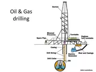
NOAA Cooperative Tower Long Term Measurement and Sampling Network Boulder Atmospheric Observatory, Erie, Weld county (NOAA PSD) Non attainment area for summer time ozone NWF SGP Denver • 300 meter tall tower • 30 sec- Meteorological Data • Daily discrete air samples from 300 meter level since Aug 2007 Denver Julesburg Basin 12,000 gas wells in Weld County ~ 900 new ones in 2006 Tower Team: Arlyn Andrews, Jonathan Kofler, Jonathan Williams
Discrete Air Samples Analyses standards MAGICC analyzers air samples Logistics: Molly Heller, Chris Carparelli, Jack Higgs Analysis: GMD: Tom Conway, Andy Crotwell, Ed Dlugokencky, Pat Lang, Paul Novelli, Kelly Stroker HATS: Ben Miller, Carolina Siso, Steve Montzka http://www.esrl.noaa.gov/gmd/ccgg/ & http://www.esrl.noaa.gov/gmd/hats/ NOAA Boulder Lab • MAGICC System (Carbon Cycle Group): • CO2, CH4, N2O, CO, H2, SF6 • CH4 repeatability error: ±1.2 ppb • GC/MS System (HATS group): • C3H8, nC4H10, iC5H12, nC5H12, C2H2, C6H6, CFCs, HFCs, PFCs… • Most species: total uncertainty <5% • n-butane and C2H2: 10-15% • High precision well calibrated measurements
BAO: Distinct Alkane Signature Median summer mixing ratio at 7 NOAA Towers Midday data only (June-Aug 2007-2009) BAO NWF SGP NOAA Cooperative Tall Tower Measurement and Sampling Network Air samples collected at the BAO and SGP* have a strong alkane signature. Both sites are in major oil and gas production regions. * SGP is a NOAA aircraft site in Northern Oklahoma. Samples collected below 650 meters were used for this analysis. GMD aircraft program leader: Colm Sweeney.
Alkane source in N&E wind sector: Denver Julesburg Basin Median mixing ratios (N>30) Aug 2007-April 2010 North & East West South Boulder Atmospheric Observatory - 30-sec met data at 3 vertical levels (NOAA PSD) - daily* midday air sample collection from 300 meter level and analysis in NOAA GMD labs Air samples from the North and East wind sector have the strongest alkane signature (all year round), suggesting this is where the alkane source is likely located.
Mobile Lab intensive sampling in Front Range Mobile Platform to sample close to sources Boulder Waste water treatment plant (up to 3.2 ppm) July 31, 2008 Landfill (up to 2.4ppm) CO2 Denver Julesburg Basin, O&G wells CH4 Targeted flask sampling on most drives: total of 88 flasks collected over June-July 2008 O3 • Picarro Sensor: CO2, CH4, H2O (Colm Sweeney, Anna Karion) • Ozone 2B Analyzer (Laura Patrick) • GPS
Same alkane signature at BAO and in Mobile Lab samples Mobile Lab BAO N&E summer • The alkanes are strongly correlated in BAO N&E wind sector samples and in Mobile Lab samples. • The alkanes come from the same source located in NE part of the Front Range. Slope: 0.10 Slope: 0.11 y=0.48x r2=1 y=0.50x r2=0.98
Multi species analysis: Separation of various methane sources July 14, 2008 Lloyd Miller, William Kolodzey subset Feedlots contribution Methane ppb Oil and gas contribution Background methane Propane ppt Samples collected with the Mobile Lab close to feedlots, a landfill, and a waste water treatment plant are above the oil and gas methane-to-propane correlation line.
Western Region Air Partnership Oil and Gas Total VOC Inventory Emission estimates for Front Range NAA 2006 based on industry data and reported emissions for permitted sources 2010 projected State regulated sources in the Front Range O3 non attainment area (NAA) Amnon Bar Ilan et al. [2008]
Speciation profiles of raw natural gas and condensate tanks flash emissions Used to derive speciated emissions for fugitive/vented emissions (raw gas) and flashing emissions from condensate tanks. The WRAP inventory used average emission profile. We used the entire documented range. Not included in GWA study Venting WRAP: average of industry data for DJB (company proprietary data) Venting Greater Wattenberg Area Study: natural gas samples from 77 wells in DJB (2006, COGCC) Flashing WRAP: EPA TANK model output for 16 condensate tanks in DJB (2002, CDPHE)
Atmospheric Molar Ratios versus Bottom-up Inventory Emission Ratios • Very good agreement. • Vertical bars show : • min and max values for flashing and fugitive emissions • 2 sigma for observed atmospheric molar ratios
Emission estimates comparison The bottom-up propane source estimate is used to derive top-down* emissions for all other species based on observed atmospheric ratios Methane source = 1.6 to 6% of Weld County natural gas production in 2008 Error bars show min/max range Used to derive top-down* estimates for other measured species ~ 50% discrepancy between bottom-up and top-down estimates for methane.
Fraction of total natural gas withdrawal vented to the atmosphere Percentage Estimates for Weld County Conventional gas and Shale gas estimates from Howarth et al. [2011]: % of methane produced over the lifecycle of a well. US average These estimates are still highly uncertain.
Conclusions • Oil and Gas operations in the Northern Front Range have a regional impact on air composition. • Bottom-up emission inventories for oil and gas operations are quite uncertain. • This was a study of opportunity to look at methane variability in the region. • Next possible steps: • Aircraft and Mobile Lab mapping of the region to derive absolute fluxes • Active chemistry study
Natural Gas Production in the US since 1936 2009 breakdown of production by state 2009 natural gas production in the US = 19.5% of world production 2010 US Total Production = 26.8 Trillion cubic feet (Tcf) From shale gas=3.4 From Coalbed= 2.0 2010 US Consumption = 24.1 Tcf
Natural gas gross withdrawal by state 2009 Breakdown