Download
1 / 52
520 likes | 530 Views
World Geography Review. Global 9 Mr. Meetze. How to Study for Geography. As we Review prepare yourself for 2 types of Essays…. 1 st Pick 1 Country from Each Region that you can Write about. 2 nd Pick 1 River, Mountain, Desert, Plain, Rainforest, Sea, Ocean, ect.

E N D
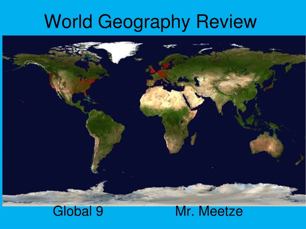
World Geography Review Global 9 Mr. Meetze
How to Study for Geography • As we Review prepare yourself for 2 types of Essays…. • 1st • Pick 1 Country from Each Region that you can Write about. • 2nd • Pick 1 River, Mountain, Desert, Plain, Rainforest, Sea, Ocean, ect.
Latin America • Latin America is a large region, encompassing almost 8 Million Square Miles or 1/6th of the Earth’s Surface. • The physical features of Latin America include vast mountain ranges, dense rain forests, and un-navigable rivers separating the people of the area blocking while restricting development of basic “Infrastructure” or ____________________. ‘Public Works’ ie. Roads/Canals
Latin America • However, Latin America is fortunate to have an abundance of Natural Resources including ____% of the worlds Coffee, ____% of Bananas, and ___% of Sugar Cane supply in addition to access to Oil, Tin, Copper, Gold, and Silver 75 60 25
Latin America • In Argentina for example, the grasslands known as the ‘Pampas’(similar to the __________ in Africa) are used for raising livestock and grains. • The creation of the Panama Canal located on the Isthmus of Panama has increased the world’s ability to travel from Atlantic to Pacific Oceans Savannah
Andes Mountain Range Peru through Argentina • A Long chain of mountains over ________ miles long. The Andes are the __________ in the Americas with the peaks reaching over ____________ tall. • Due to the height of the Andes and limited mountain passes it is difficult for the people of the Andes to do the following things….. • Little T,T, & CD leads to Cultural Diversity or…. • What is Terrace Farming’? Draw it on your Packet 2,000 tallest 20,000 ft.
Case Study: BrazilAmazon River Basin & Rainforest • The Amazon begins in the Andes and is over 3,000 miles long second only to the Nile River in Africa. • Over 2% of the world’s fresh water supply comes from here. • Unfortunately it is impossible to farm this region due to the dense jungle brush.
Case Study: BrazilAmazon River Basin & Rainforest • People here need to incorporates ‘Slash and Burn’ agriculture which… • Potential problems with cutting down the Amazon Rainforest? • Each year the Size of New York Cut • 50% of Worlds Plant Species found here so… • Decrease of O2 while increase of CO2 so…
Africa • Africa is the Second Largest Continent in land mass measuring 3 Times the Size of the Continental United States. • The origins of humanity can be traced to fossilized remains located in the ‘Great Rift Valley’. • Both geographic features and climate worked together to keep Africa as an unknown continent which could be referred to as the “______ _________”. Dark Continent
Africa • The Savanna or __________ covers about ___% of the land and is very similar to the ____________ in Latin America. • The people of the Savanna which is home to the ‘Safari’ developed a way to trace their ancestry through their language called _________________. Grasslands 40 Pampas Bantu Migrations
Africa • Over ____% of the land is unsuitable for agriculture due to the size of the Deserts, Mountain Ranges, and Rainforests. • In addition only the ‘Irregular Coastlines’ in the NW, SW, and NE provide access into the continent. • Un-Navigable rivers and the Continental Plateau have limited the interior access to Africa. 95 Side View of Africa
Africa • Fortunately the land of Africa is rich with natural resources including, Oil, Gold, Copper, Diamonds, Cobalt, Cotton, Peanuts, Coffee, and Lumber which can be sold for huge Profits. • (Question) Why will the European’s want access into Africa during the Post Slave Trade Period? • Leads to Imperialism or… and the ‘Scramble for Africa’
The Sahara Desert Egypt or Libya • The word Sahara literally means ‘_____________’ which is mostly uninhabitable. • The largest desert in the world at 3.5 Million square miles this area lack water except for __________ which…. • Only 1/3 of the desert is sand dunes, while 2/3 is actually rocky plateaus or plains w/pebbles and rocks. • Potential Problems with the Sahara Desert include ‘Desertification’ or……, & • Slash n Burn Farming, Lack of Salt, & use of Camels. Emptiness Oasis
Case Study: Egypt • Remember to use the Sahara Desert as well • The Nile River The longest river in the world at 4,000 miles the Nile forms a ‘Delta’ or …at the Mediterranean Sea. • The area near the Nile in Egypt is extremely fertile but much of the river has many ‘Cataracts’ or __________ which… • The Creation of the Aswan High Dam which… Waterfalls
Case Study: Egypt Aswan High Dam
Middle East • The Middle East is NOT one giant desert and in fact has great geographic diversity encompassing approximately Twice the Size of the United States. • Home to the Sahara Desert, Nile River Basin, Arabian Peninsula, Anatolia Plateau (Turkey), and the “Fertile Crescent” the Middle East has been the center for world trade since early civilization.
Middle East • Surprisingly over ____ % of land is ‘Arable’ or _________________and is a chief world supplier of Dates. • In addition the Middle East has access to over ____% of the world Oil Supply using the access of the Persian Gulf and Suez Canal to foster world wide trade through OPEC 15 Fertile 75
Case Study: Iraq • The ‘Fertile Crescent’ (Iraq, Iran) is located between the E______ & T________Rivers. • The Fertile Crescent is home to the World’s 1st Civilizations including the following.. • Meso, Sumer, Babylon, Hittites, Assyria, Persia • Unfortunately due to the location the ‘Fertile Crescent’ is constantly • ATTACKED!! ALWAYS! T E In Addition, Waterways, Oil, & Desert Climate
South & South East Asia • Life in South Asia’s ‘Subcontinent’ in one that has enormous influence on the culture and economies of the countries located their today. • The people of South Asia are totally dependent on the Monsoons or _______ ______ while the people of Southeast Asia are Culturally Diverse due to the physical separation between the Mainland and numerous Archipelagos found in the region Seasonal Winds
Case Study: India • The Himalaya Mountains are the highest mountains in the world extending 1,500miles in length separating India and China while reaching the highest point of 29,035 feet called Mt. _________. • To the West only the __________ pass allowed groups such as the Aryan's and Alexanderthe Great access into the Deccan Plateau onto the ____________ valley. • Eventually people will move to the _________ valley which will become sacred to the ____________ religion of India. Everest Khyber Indus Ganges Hinduism
Mt. Everest Ganges River
Case Study: India • The ‘lifeblood of the India’ is the Monsoon or the _______ _____which consists of both Summer and Winter Patterns. • Summer = • Winter = • List the potential problems associated with the Monsoons. • Too Early.., Too Late.., Too Little.., Too Much.. Seasonal Winds
Case Study: China • The people of China are Isolated due to the surrounding barriers including the Gobi Desert, Tibet Plateau, Kunlun/Tien Shan Mountains, the ‘Great Wall’, Pacific Ocean, the Rainforests of SE Asia, and the Himalayas. • Due to this isolation the so called ‘_________-__________’ will begin to believe in the idea of ‘Ethnocentrism’ or…. Middle Kingdom
Without access to the _______ ______ China would remain isolated. • In fact over 80% of the population live in the area know as ‘China Proper’ located between…. • Yellow & Yangtze Rivers near the Pacific Ocean Coastline • Unfortunately the people of China rely on the Yellow River which is sometimes known as the ‘River of Sorrow’ due to.. Silk Road
Case Study: Korea • Located between __________ & _________ Korea is an land bridge which… • ‘Idea Bridge’ leading to adoption of practices from both countries. • By 1500’s in order to stop Christian missionaries the so called ‘Hermit Kingdom’ will… • Close off their borders and ports to all outsiders ending any C.D. China Japan
Case Study: Japan Archipelago • Japan is an ___________ or a chain of 4 large and thousands of smaller islands with an Irregular Coastline ___________. • Over _____% of the land is Mountainous with _____ being the highest Peak. • Lacking ___________ & ____________ Japan has a high population density and looks to the Sea to sustain the population. Ports 75 Mt. Fuji Living Space Farming
Case Study: Japan • Using _______ Farming the Japan use the mountains to create useable land since the numerous rivers are short with many rapids and can not easily be used for irrigation. • Due to it’s location on the ‘Ring of Fire’ Japan constantly must… Terrace
Case Study: Japan • Over ___ % of Oil is imported from the Middle East while other necessities such as Coal & Iron are traded with other global powers. • This lack of Natural Resources will lead to an aggressive policy during WWII. • During the 1500’s under the Tokagawa Shogunate the country will practice a policy of Seclusion which… • Closes the Borders, Isolates, leading to No CD until 1850 95
Surrounded by bodies of water on three sides, Western Europe is one large ____________ with over 50,000 miles of coastline ( ) • In fact no location within Europe in more than 300 miles from aPort allowing many cultures access to overseas Empires and International trade. (**Think the Age of Exploration**) Peninsula Irregular- Has Ports
Western Europe • Western Europe is home to numerous bodies of water including the Adriatic, Aegean, Baltic, Black, Mediterranean, and North Seas as well as the Danube, Rhine, Po, and Thames Rivers leading to HUGE T,T, & C.D!!!!
Western Europe • Some areas have the protective benefit of high mountain ranges such as the Alps, Balkans, and Pyrenees.
Western Europe • Unfortunately the countries of France, Germany, and Poland reside on the ________ ______ _______a fertile area which has no natural barriers allowing people like Hitler and Napoleon to sweep through their countries with ease. Great Northern Plain
Case Study: Great Britain • The nation of Great Britain is located on an Island between the Atlantic Ocean and North Sea. • Due to the Irregular Coastline or ___________ the British will develop into a Seafaring nation with a strong navy, and numerous colonies becoming a world wide trading empire. • Access to a large deposit of _______ & _______ will lead the British to become the first nation to experience the __________ ____________. Has Ports Coal & Iron Industrial Revolution
Case Study: Great Britain • The last time the British were successfully invaded was in 1066 when_______the _________won the ‘Battle of Hastings’ by crossing the English Channel while both __________ & ________ failed to subdue Great Britain during the 1800’s & 1900’s respectively. William the Conqueror Napoleon & Hitler
Eastern Europe & the Former U.S.S.R. • The area of Eastern Europe and the Former U.S.S.R. is more than 12 Million Square Miles and is more than 2.5 Times the Total Size of the United States. • Ranging from the Tundra to the think black soil of the Ukraine, this region has a diverse climate allowing for the development of many different types of cultures
Eastern Europe & the Former U.S.S.R. • In Eastern Europe the Danube River or the ‘Mississippi of Eastern Europe’ winds it s way eastward from Germany past many major cities in Austria, Hungary, Serbia, Bulgaria, and Romania on its way to the Black sea. • Not only used for trade allowing land locked countries access to the sea the DanubeR. is primary source of fishing, irrigation, and hydroelectric power.
Eastern Europe & the Former U.S.S.R. • The Ural Mountain range technically divide the continents of Europe and Asia helped to keep early Russia isolated but due to their low level are not much of a barrier to potential invaders.
Case Study: Russia • The people of Russia have been slow to ‘W_________’ or ____________ due to their isolating Geography. • Lacking ________ _________ ports the Russian people needed to gain access to both the Baltic and Black Sea. esternize Industrialize / Modern Warm Water
Case Study: Russia • The climate of Russia in the north where the Tundra ( frozen land) and Taiga (pine tree line) are located can be difficult to adapt to.
Case Study: Russia • Much of Russia has short summers with cold winters except in the Ukraine where the black rich soil produces most of the food. • During war both ‘General Winter’ _____and the use of the ‘Scorched Earth Policy’ or _______________have been difficult for enemies to overcome. Fake Burn it All!!
World Geography Assignments Both Due This Friday • Log onto Castle Learning 50 World Geography Review Questions • Counts as a 40 pt HW Check, 100 pt Test • Block out and Write the 2 Body paragraphs from either Geographic Thematic Essay in your Review Pack (#3 or #4) Counts as a 50 pt Writing assignment