Download
1 / 35
350 likes | 560 Views
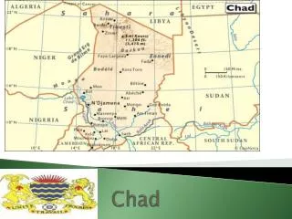
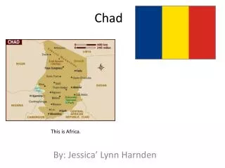
REPUBLIC OF CHAD WELCOME TO CHAD. By: MOLENGAR NGOUNDO Master’s of Science (Dec., 2003). CHAD Location : North-Central Africa. Landlocked country, bounded by Cameroon, Nigeria, Niger in West; Central African Republic in South, Sudan in East; Libya in North. Geographic coordinates :

E N D
REPUBLIC OF CHAD WELCOME TO CHAD By: MOLENGAR NGOUNDO Master’s of Science (Dec., 2003)
CHAD Location: North-Central Africa. Landlocked country, bounded by Cameroon, Nigeria, Niger in West; Central African Republic in South, Sudan in East; Libya in North. Geographic coordinates: 15 00 N, 19 00 E Total area: 1,284,000 Km2. Flag: Blue- Yellow - Red AFRICA MAP
CLIMATE Tropical in South, Desert in North, the climate is caracterized by three ecological zones: 1. Saharian zone desert in North: ( < 200 mm of rain); 2. Sahelian zone in Center: (200 mm to 700 mm of rain) ; 3. Soudanian zone in South: (700 mm to + 1,000 mm of rain). Two seasons: Rainy season (From June to early September in sahelian zone and from April to October in Soudanian zone) Dry season from October to May in Sahelian Zone and from November to March in Soudanian zone. Saharian Zone SahelianZone SoudanianZone
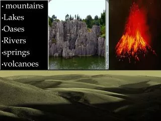
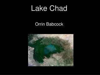
RELIEF AND HYDROGRAPHY RELIEF Desert in North with mountains and plateaus in North-East, arid, savanna with Lake Chad in West, massif in Center, highland in East and lowlands in South. Lowest point, Djourab: 160m; Highest point, Emi-koussi: 3,415 m HYDROGRAPHY Permanent rivers: Logone (1,000 km long), Chari (1,200 km long). Lakes: Lake Chad (25,000 km2 before 1970, now 10,000 sq.km). Seven other lakes total area of 720 Km2. Underground water. Renewable: 20.6 million m3/year; Exploitable: 263 to 455 million m3 /year.
Slow progression through the Sahara Desert of Chad Mountains of Tibesti Ouedds of Zoumri
Emi Koussi, Tibesti, Chad Location: 19.80 N, 18.53 EElevation: 11,204 ft. (3,415 m) Tousside, Tibesti, Chad Location: 21.03N, 16.45EElevation: 10,712 ft. (3,265 m)
Mountains of Ennedi Tibesti, Hole of Natron (Sodium bicarbonate) Tibesti, Neolotic prints on the mountains of Bardaï Landscape of Tibesti
Chari River Lake-Chad and its hippopotamuses
This is a space shot provided by the US Geological Survey, taken in 1963. This is a space shot taken in October 1968. This was taken in 1997. Essentially, the lake has been reduced to that dark portion at the end of the yellow arrow.
AGRICULTURAL AREAS Arable lands: Total area: 39 million ha, Cultivated: About 2.2 million ha / year. Irrigable lands: Total irrigable area: 5.5 million ha, Exploited surface: 7,000 ha
SOCIO-ECONOMIC ENVIRONMENT 1. NATURAL RESOURCES • Bauxite, Uranium, Oil, Gold, Ore, Natron (sodium carbonate), Kaolin, Fish (Lake Chad). • Petroleum (exploited on 2 sites: The first one in South financed by World Bank for exportation and the second one in North financed by R.O.C. for local consumption).
Pipeline 1,070 Km ESSO-CHAD DOBA Oil Basin (250,000 bbl day-1) Chad – Cameroon pipeline Consortium: EXXON-CHEVRON-PETRONAS-CHAD
2. POPULATION AND ADMINISTRATIVE SITUATION Population: 8,707,078 inhabitants (2001 E). Population growth rate: 3.31%. Birth rate: 45 births/1,000 (2000) Infant mortality rate: 101 deaths/1,000 (2000) Life expectancy at birth: 47 yrs Male, 50.5 yrs Female. Officials languages: French, Arabic. Government: Type Republic, Capital: N’Djaména Administration Division: 8 Regions, and 47 Departments.
H.E. Mr. IDRISS DEBY PRESIDENT OF THE REPUBLIC OF CHAD
3. ECONOMY • Major industries: Cotton, Meat packing, Natron, Soap, Cigarettes, Beer brewing, Sugar, Construction materials and recently Gold and Petroleum. • GDP-purchasing power parity:$7.6 billion. • GDP-per capita:$240. • Annualgrowth: 8% • GDP-composition by sector: Agriculture: 38%; Industry and breeding: 14%, Services: 48%.
3. ECONOMY (Cont’d) Exportation: Chad exports cotton, Arabic gum, cotton textiles, livestock, to some countries such as Nigeria, South Africa, Costa Rica, France, Portugal, Germany, Thailand, USA. Importation: Although Chad has largely achieved food self-sufficiency foodstuffs still constitute most of the country’s imports. Other import products include machinery, transportation equipment, and industrial goods. Chad also imports petroleum products although this is expected to change in the near future as the country starts to exploit its own resources.
4. NATURAL ENVIRONMENT • Animals: abundant and various, they are mammals the most representative of African continent (134 species and 14 threatened species); • Migratory birds: 370 species interesting Ostrich and 15 threatened species. • Natural forests: 32.5 million hectares with 1,600 species of higher plants.
Some animals in Zakouma Park Equinoxial Buffalo Elephant Hippopotamus Cheetah Lion Rhinoceros Phacochere Oryx
Birds in the river Ostrich
Pupils go to school throughout the forest Type of forest in extreme South of Chad
SYSTEM OF PRODUCTION • Three types: • 1.Oasian system: Date production, camel breeding, subsistence irrigated agriculture. • 2. Pastoral and agro-pastoral system: Dune cultivation, nomadic breeding, irrigated agriculture. • 3.Diversified soudanian system: Cereals cultivation, cotton, tubercle, traditional cultivation through forestry, fishing, hunting.
Oxen bororo Sheep
AGRICULTURAL CHANNELS • 1.Cereals Channel: main feeding of Country • 2. Fruit, vegetable Channel: less developed. • 3.Root, tubercle channel: contribute to food security. • 4. Cotton Channel: Contribute to 12% on GDP. • 5. Breeding Channel: 12 million of heads. • 6. Forest, Fishing, Hunting Channel.
RURAL WORLD STRUCTURES • Basic organizations: (28,000) Farmers’ grouping; (4,000) Villagers’ Association. • Legal and Institutional Environment: Civil service reform, decentralization, privatization and promotion of private sectors. • Sustaining service in rural environment: Extension, Plants protection, Animal health and, • Research: Six institutions of Research.
GENERAL STRATEGY OF DEVELOPMENT • Strategy in general frame of fighting against poverty: • 1. Strengthening financial stabilization • 2. Developing sectors of growth and promoting private operators of development ; • 3. Improving infrastructures to access to other regions and correcting regional unbalance; • 4. Reforming State, • 5. Reinforcing national capacities of management..
Camel for transportation Traditional holiday Traditional instruments for dancing Tourists observing a flock of elephants
CONCLUSION • Landlocked country, Chad’s economic development suffers from its geographic remoteness, drought, lack of infrastructures, lack of mastery of agricultural production and continuous political turmoil. • Unavailability and inaccessibly factors of production materials pose essential problems on well- being of population. • Nevertheless, with the exploitation of petroleum, hope for overcome some development handicaps is permitted.