Download
1 / 35
380 likes | 578 Views
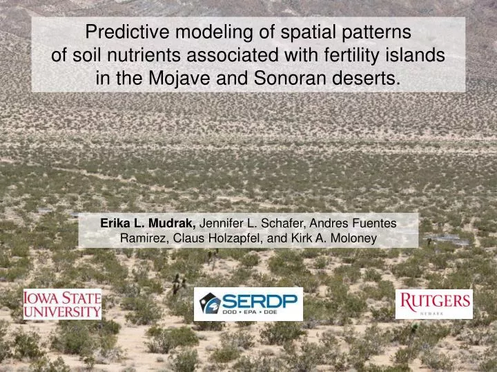
Predictive modeling of spatial patterns of soil nutrients associated with fertility islands in the Mojave and Sonoran deserts. . Erika L. Mudrak, Jennifer L. Schafer, Andres Fuentes Ramirez, Claus Holzapfel, and Kirk A. Moloney. Fertility Islands. Shrub canopies provide windbreak

E N D
Predictive modeling of spatial patterns of soil nutrients associated with fertility islands in the Mojave and Sonoran deserts. Erika L. Mudrak, Jennifer L. Schafer, Andres Fuentes Ramirez, Claus Holzapfel, and Kirk A. Moloney
Fertility Islands • Shrub canopies • provide windbreak • provide shade • funnel and retain moisture • native annuals grow • increased accumulation of organic matter • Increased soil nutrients under the shrub • Creates resource heterogeneity • Structurally defines the landscape Larrea tridentata creosote bush
Project Goals: • Ultimate: • Develop landscape-scale, spatially-explicit agent-based models • - patterns of invasion by non-native annuals • effect of fire cycle and climate change on these dynamics • test possible management plans • Current: • Characterization of landscape: • perennial plant community • soil nutrient availability • water availability • annual plant community soil nutrient availability
Measuring fertility islands Semi-variance (γ) Lag distance (cm) Schlesinger et al. 1996 Ecology Thompson et al. 2005 Journal of Arid Environments Li et al 2011 Ecological Research Jackson and Caldwell 1993 Journal of Ecology
Soil nutrient distribution • Goal: Develop a model of soil nutrient concentration as a function of • distance from nearby shrubs • direction (N or S) • the size of those nearby shrubs • landscape heterogeneity • underlying autocorrelation structure.
Mojave Ft. Irwin NTC Sonoran Barry M Goldwater AFAF
Buried during growing season: Late January – Late March 2011 PRS (Plant Root Simulator)™-probes Plant available forms of macronutrients NH4+ + NO3- N H2PO4- P K+ K Ca2+ Ca Mg2+ Mg
distance from nearby shrubs • the size of those nearby shrubs • landscape heterogeneity • direction (N or S) • underlying autocorrelation structure PRS (Plant Root Simulator)™-probes ? Plant available forms of macronutrients NH4+ + NO3- N H2PO4- P K+ K Ca2+ Ca Mg2+ Mg
0 20 40 60 80 100 120 140 160 180 200 220 240 x x x x x x x x x x x x x • distance from nearby shrubs • the size of those nearby shrubs • landscape position (trend) • direction (N or S) • underlying autocorrelation structure ? = sample location x Nutrient Level ? ? Distance from shrub (cm)
distance from nearby shrubs • the size of those nearby shrubs • small, medium, large • landscape heterogeneity • direction (N or S) • underlying autocorrelation structure
distance from nearby shrubs • the size of those nearby shrubs • small, medium, large • landscape heterogeneity • 3 regions • direction (N or S) • underlying autocorrelation structure. 25 x 25m
distance from nearby shrubs • the size of those nearby shrubs • small, medium, large • landscape heterogeneity • 3 regions • direction (N or S) • underlying autocorrelation structure. 25 x 25m
distance from nearby shrubs • the size of those nearby shrubs • small, medium, large • landscape heterogeneity • 3 regions • direction (N or S) • underlying autocorrelation structure. 25 x 25m
distance from nearby shrubs • the size of those nearby shrubs • small, medium, large • landscape heterogeneity • 3 regions • direction (N or S) • north, south • underlying autocorrelation structure 18 shrubs 3 sizes × 3 regions × 2 directions
Mojave Sonoran N mg/m2/46 days mg/m2/63 days P mg/m2/46 days mg/m2/63 days K mg/m2/46 days mg/m2/63 days Ca mg/m2/63 days mg/m2/46 days Mg mg/m2/46 days mg/m2/63 days
Model Types Linear Shrub as random effect nutrient= m∙ dist + c + ε m c Negative Exponential Shrub as random effect nutrient = a∙ exp(-b∙ dist) + d + ε a b d Regional Trend No shrub influence nutrientxy = x2 + x + x2y + xy + y2x + y + y2 + εxy,
Non-linear hierarchical modeling Negative exponential: Nutrient ~ a ∙ exp(- b ∙ Distance) + d + ε Shrubs must be considered a random effect! • Model Selection • Removed non significant parameters one a time • Compared candidate models with AIC • Checked model residuals for spatial trends and autocorrelation • None! ai = a0 + a0s +a1∙Area+a1s∙Area+ εai, εai ~ N(0, σa) bi = b0 + b0s +b1∙Area+b1s∙Area+ εbi,εbi ~ N(0, σb) di = d0 + d0s +d1∙Area+d1s∙Area+ εdi,εdi ~ N(0, σd) ai = a0 + a0s +a1∙Area+a1s∙Area+ εai bi = b0 + b0s +b1∙Area+b1s∙Area+ εbi di = d0 + d0s +d1∙Area+d1s∙Area+ εdi a b d • Allow parameters a, b, and d to depend on • shrub size • transect direction
Sonoran Mojave Neg. Exp. Neg. Exp. N mg/m2/46 days mg/m2/63 days Regional Regional P mg/m2/46 days mg/m2/63 days Neg. Exp. Neg. Exp. K mg/m2/46 days mg/m2/63 days Neg. Exp. Neg. Exp. Ca mg/m2/63 days mg/m2/46 days Regional Linear Mg mg/m2/46 days mg/m2/63 days
Nutrient Concentration Translating model equations to raster hotspot map Northing Stochastic! Easting Regional Model Northing
Shrub Map N: Neg. Exp. K: Neg. Exp. 00 Sonoran Study Site mg/m2/46 days mg/m2/46 days Ca: Neg.Exp. P: Regional Mg: Linear mg/m2/46 days mg/m2/46 days mg/m2/46 days
Shrub Map N: Negative Exponential Mojave Study Site mg/m2/63 days Ca: Negative Exponential K: Negative Exponential mg/m2/63 days mg/m2/63 days P: Regional Mg: Regional mg/m2/63 days mg/m2/63 days
Model Validation sampled transects on new shrubs 8 shrubs 4 sizes × 2 directions Buried late January - late March 2012
Model Validation Modeled values Field samples
Model Validation Modeled values Field samples • 100 simulations • mean R2 value • % of times P < 0.05
N: Neg. Exp. K: Neg. Exp. Model Validation Sonoran Study Site mean R2 = 63% significant: 100% mean R2 = 34% significant: 100% mg/m2/46 days mg/m2/46 days Results from 100 model simulations Ca: Neg.Exp. P: Regional Mg: Linear mean R2 = 15% significant: 74% mean R2 = 3% significant: 9% mean R2 = 4% significant: 13% mg/m2/46 days mg/m2/46 days mg/m2/46 days
N: Negative Exponential Model Validation Mojave Study Site mean R2 = 9% significant: 72% mg/m2/63 days Results from 100 model simulations Ca: Negative Exponential K: Negative Exponential mean R2 = 4% significant: 17% mean R2 = 45% significant: 100% mg/m2/63 days mg/m2/63 days P: Regional Mg: Regional mean R2 = 3% significant: 9% mean R2 = 2% significant: 4% mg/m2/63 days mg/m2/63 days
Conclusions • Models were successful for nutrients with strong relationships with distance to shrub. • Modeled by negative exponential function • N and K in the Sonoran and K in the Mojave were very successful. • N in the Mojave: Significant, but weak explanatory power • Due to co-dominance of Ambrosia? • More rain in 2012, N particularly sensitive to water pulsing
Future Directions • Apply models to shrub distributions estimated from aerial photos Burned N S Unburned • Create models for nutrients after experimental fire
Thank you! • Carolyn Haines, Marjolein Schat- Field work! • Ft. Irwin support: David Housman , Ruth Sparks, Alex Misiura • Barry Goldwater AFAF support: Teresa Walker, Richard Whittle • Dennis Lock of the Iowa State University Statistics Consulting Services Project RC-1721 Holzapfel & Moloney
0 20 40 60 80 100 120 140 160 180 200 220 240 x x x x x x x x x x x x x x x x x x x x x x x x x x x x x x 0 20 40 60 80 100 120 140 160 180 200 220 240 260 280 x x x x x x x x x x x x x x x x x x x x x x x x x x x x x x x • distance from nearby shrubs • the size of those nearby shrubs • landscape position (trend) • direction (N or S) • underlying autocorrelation structure Nutrient Level = sample location x Distance from shrub (cm) Sonoran near middle far near Mojave middle far
Translating model equations to raster hotspot map Northing Easting Northing
Model Validation Results from 100 model simulations
% signif Mean R2 % signif Mean R2 Sonoran Mojave Neg. Exp. Neg. Exp. N 63% 100% mg/m2/46 days mg/m2/63 days 9% 72% Regional Regional P 1.8% 4% 2.5% 9% mg/m2/46 days mg/m2/63 days Neg. Exp. Neg. Exp. K 34% 100% 45% 100% mg/m2/46 days mg/m2/63 days Neg. Exp. Neg. Exp. Ca 15% 74% 4% 17% mg/m2/63 days mg/m2/46 days Regional Linear Mg 3.7% 13% 1.8% 4% mg/m2/46 days mg/m2/63 days