Download
1 / 4
40 likes | 178 Views
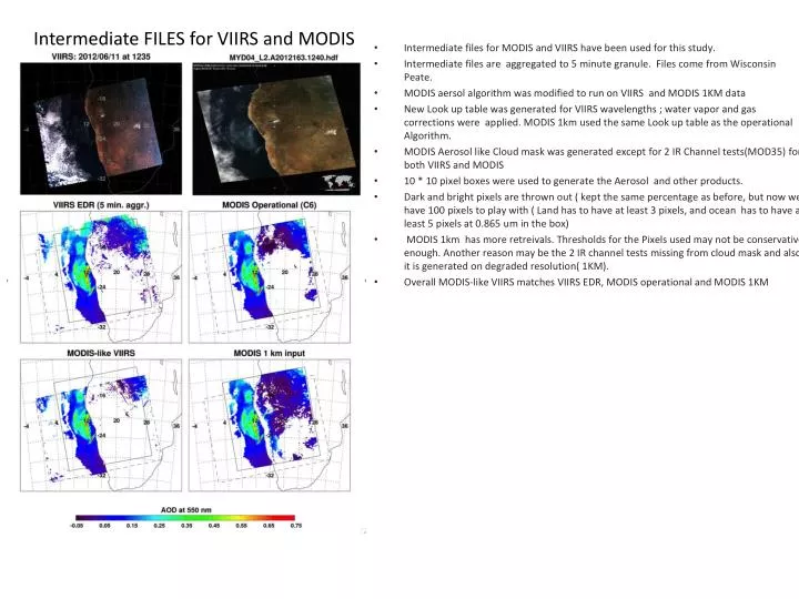
Intermediate FILES for VIIRS and MODIS. Intermediate files for MODIS and VIIRS have been used for this study. Intermediate files are aggregated to 5 minute granule. Files come from Wisconsin Peate. MODIS aersol algorithm was modified to run on VIIRS and MODIS 1KM data

E N D
Intermediate FILES for VIIRS and MODIS • Intermediate files for MODIS and VIIRS have been used for this study. • Intermediate files are aggregated to 5 minute granule. Files come from Wisconsin Peate. • MODIS aersol algorithm was modified to run on VIIRS and MODIS 1KM data • New Look up table was generated for VIIRS wavelengths ; water vapor and gas corrections were applied. MODIS 1km used the same Look up table as the operational Algorithm. • MODIS Aerosol like Cloud mask was generated except for 2 IR Channel tests(MOD35) for both VIIRS and MODIS • 10 * 10 pixel boxes were used to generate the Aerosol and other products. • Dark and bright pixels are thrown out ( kept the same percentage as before, but now we have 100 pixels to play with ( Land has to have at least 3 pixels, and ocean has to have at least 5 pixels at 0.865 um in the box) • MODIS 1km has more retreivals. Thresholds for the Pixels used may not be conservative enough. Another reason may be the 2 IR channel tests missing from cloud mask and also it is generated on degraded resolution( 1KM). • Overall MODIS-like VIIRS matches VIIRS EDR, MODIS operational and MODIS 1KM
MODIS Airborne Simulator (MAS) data was used for this study. This data has been used to test, and refine algorithms for the MODIS Sensors. • Data was aggregated to MODIS wavelength resolutions. Operational Lookup tables were used • Modified MODIS aerosol algorithm was used to retrieve the aersol products for 10 * 10 Pixel box. MAS RGB Cloud mask without Cirrus Tau (0.55um) scale 0-0.8
RGB MODIS TERRA • GLI is an optical sensor that observes the reflected solar radiation from the Earth's surface, including land, oceans and clouds and/or infrared radiation with a multi-channel system. (JAXA Japan Aerospace Exploration Agency) • Still to figure out how to apply cloud mask. • The algorithm runs for each pixel ( stand alone code) and optical depth is retrieved for each pixel. • Still very very preliminary. RGB MODIS Terra No cloud masking Terra MODIS Optical depth(0.55um) GLI Retrieved Optical depth(0.55 um)