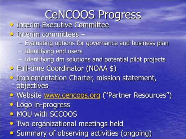
Download
1 / 11
110 likes | 339 Views
CIMT (HF radar, ship-based measurements, mooring, marine mammal tracking, satellite imagery) PISCO (diver surveys; nearshore biological/physical measurements) ...

E N D
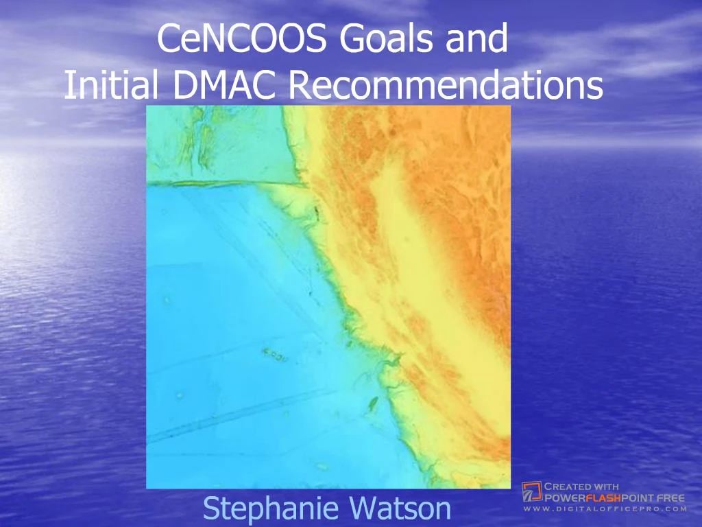
Slide 1:CeNCOOS Goals and Initial DMAC Recommendations
Stephanie Watson Geographic scope: Point Conception to CA-OR border, coastline to seaward extent of EEZ; involves >1000 km of coastlineGeographic scope: Point Conception to CA-OR border, coastline to seaward extent of EEZ; involves >1000 km of coastline
Slide 2:U.S. Integrated Ocean Observing System (IOOS)
Two components: global/basin scale (feeds the Global OOS) coastal Coastal component includes: National backbone: satellites, reference and sentinel stations on core variables (many are physical), long-range HF radar (proposed), standards for data management and communications Regional Associations: focused on land-based inputs, state and regional priorities, greater spatial and temporal resolution, more variables (especially more focus on biological and chemical) National backbone provides a consistent infrastructure throughout the U.S. coast. Regional Associations will be coordinated by a National Federation of Regional Associations, with representation from each of the regions. National backbone provides a consistent infrastructure throughout the U.S. coast. Regional Associations will be coordinated by a National Federation of Regional Associations, with representation from each of the regions.
Regional Associations in the IOOSSlide 3:There are 11 (including the Caribbean, not depicted) regional observing systems developing in the United States. Another update to this slide is the fact that Northern California is combined with Central California, instead of with Washington/Oregon. Intent is to coordinate ocean observing activities and applications on a regional basis. Idea is that by �07 there will be no more congressional earmark funding to individual programs and that funding will be directed through the regional associations. Each regional association, then, has to have a community-based structure and process for determining funding priorities. The idea is that the Regional Associations are also the appropriate scale for many of the observing activities (build on strong partnerships that already exist, economic benefits will be most prominent on this scale) The Ocean.US is now developing a certification process, which all the regional groups will have to go through to be fully recognized and fundable regional OOSs. The certification criteria will likely include a formal governance structure and approved business plan. And, as I mentioned on the previous slide, we will have a National Federation of Regional Associations to coordinate the regional efforts. There are 11 (including the Caribbean, not depicted) regional observing systems developing in the United States. Another update to this slide is the fact that Northern California is combined with Central California, instead of with Washington/Oregon. Intent is to coordinate ocean observing activities and applications on a regional basis. Idea is that by �07 there will be no more congressional earmark funding to individual programs and that funding will be directed through the regional associations. Each regional association, then, has to have a community-based structure and process for determining funding priorities. The idea is that the Regional Associations are also the appropriate scale for many of the observing activities (build on strong partnerships that already exist, economic benefits will be most prominent on this scale) The Ocean.US is now developing a certification process, which all the regional groups will have to go through to be fully recognized and fundable regional OOSs. The certification criteria will likely include a formal governance structure and approved business plan. And, as I mentioned on the previous slide, we will have a National Federation of Regional Associations to coordinate the regional efforts.
Slide 4:CeNCOOS Mission Statement
�to coordinate and support the development and implementation of a regional ocean observing system, as part of the U.S. Integrated Ocean Observing System, which provides data and data products to a diversity of end users on spatial and temporal scales appropriate for their needs.
Slide 5:Some observing activities in CeNCOOS Region
CICORE (hyperspectral imagery, multibeam bathymetry, shore-based stations) CIMT (HF radar, ship-based measurements, mooring, marine mammal tracking, satellite imagery) PISCO (diver surveys; nearshore biological/physical measurements) CalCOFI/PACOOS (ship-based biological/physical measurements and many other platforms) MBARI (moorings, AUVs, gliders, satellite imagery) NEOCO (shore-based stations � variety of parameters) COCMP-NC (HF radar, models, use of CDIP and satellite imagery) Bodega Coastal Ocean Observatory (HF radar, moorings, in situ data � variety of parameters) MBARI MUSE 2000 This is a slide of some of the ocean observing activities in the CeNCOOS region - idea is that CeNCOOS will become an umbrella organization Selection of the >76 included in a summary that the CeNCOOS coordinator has been compiling as of fall 04, with over 1000 sites. CICORE= Center for Integrated Coastal Observations, Research and Education (funded through COTS � CSU campuses coastwide) CIMT = Center for Integrated Marine Technologies (COTS � focused on Monterey Bay) PISCO = Partnership for Interdiscplinary Study of the Coastal Ocean CalCOFI=CA Cooperative Fisheries Investigation/PACOOS = Pacific Coastal Ocean Observing System MBARI = Monterey Bay Aquarium Research Institute NEOCO = Network for environmental observations of the coastal ocean (UC campuses coastwide) COCMP- NC = northern CA component of the statewide Coastal Ocean Currents Monitoring Program (HF radar and other measurements/models to provide information on surface currents) - $21 M in bond funds for the statewide program Point of this summary of existing observing activities is to provide a systematic approach to identifying potential overlaps and gaps between existing programs. Need to know where we are/what we have before we can decide where we need to go to meet user needs Real way to integrate these programs is through data management and integration (which might be a focus of an upcoming pilot project.) Data management in each of these programs is being accomplished in a different way at present, e.g, CI-CORE has site specific in situ data available in near real time or historical from the web, while CIMT is aiming for a hybrid data management approach with web accessiblity for near real time or historical data (some distributed, some centralized), NEOCO has a centralized Oracle relational database with web accessible real time data or historical data, and CaLCOFI has several ongoing databases. MBARI is building a data system for diverse data sets that can act centralized or distributed. COCMP using ROADNET which provides real-time data access via Scripps (uses object ring buffers with traditional databases in the background. PACOOS data management to follow DMAC guidelines. These disparate data management approaches are okay (not ideal) as long as the systems can interoperate. This is a slide of some of the ocean observing activities in the CeNCOOS region - idea is that CeNCOOS will become an umbrella organization Selection of the >76 included in a summary that the CeNCOOS coordinator has been compiling as of fall 04, with over 1000 sites. CICORE= Center for Integrated Coastal Observations, Research and Education (funded through COTS � CSU campuses coastwide) CIMT = Center for Integrated Marine Technologies (COTS � focused on Monterey Bay) PISCO = Partnership for Interdiscplinary Study of the Coastal Ocean CalCOFI=CA Cooperative Fisheries Investigation/PACOOS = Pacific Coastal Ocean Observing System MBARI = Monterey Bay Aquarium Research Institute NEOCO = Network for environmental observations of the coastal ocean (UC campuses coastwide) COCMP- NC = northern CA component of the statewide Coastal Ocean Currents Monitoring Program (HF radar and other measurements/models to provide information on surface currents) - $21 M in bond funds for the statewide program Point of this summary of existing observing activities is to provide a systematic approach to identifying potential overlaps and gaps between existing programs. Need to know where we are/what we have before we can decide where we need to go to meet user needs Real way to integrate these programs is through data management and integration (which might be a focus of an upcoming pilot project.) Data management in each of these programs is being accomplished in a different way at present, e.g, CI-CORE has site specific in situ data available in near real time or historical from the web, while CIMT is aiming for a hybrid data management approach with web accessiblity for near real time or historical data (some distributed, some centralized), NEOCO has a centralized Oracle relational database with web accessible real time data or historical data, and CaLCOFI has several ongoing databases. MBARI is building a data system for diverse data sets that can act centralized or distributed. COCMP using ROADNET which provides real-time data access via Scripps (uses object ring buffers with traditional databases in the background. PACOOS data management to follow DMAC guidelines. These disparate data management approaches are okay (not ideal) as long as the systems can interoperate.
Slide 6:IOOS provides an end-to-end system
3 Subsystems: Observational Data Management and Communications Analysis, Modeling and Applications MBARI MUSE 2000 DMAC plan This is what CeNCOOS is all about the observational Subsystem� consists of the infrastructure of platforms, sensors, sampling devices, and measurement techniques needed to measure variables on the time and space scales needed to detect and predict changes in coastal and open ocean environments. Remotely sensed and in situ measurements and their transmission from platforms Data management and communication � data discovery, transport, on-line browse, archive. Lots of raw data coming in from the observing system, very quickly. Includes data ingest, archive, data communications to move data among systems and users in a distributed environment First goes into the primary data assembly and quality control And then this data is made available through a uniform data management and communications infrastructure, governed by standards and specific protocols This standardized communications infrastructure allow us to share data between regional systems, between our ocean observing system and terrestrial and atmospheric systems, as wll as with the international ocean observing efforts. This standardized communications infrastructure also allows us to contribute data to the modeling and analysis subsystem (which I�ll discuss next) for the development of products The standardized communications infrastructure also allows us to provide to and extract data from data archives an analysis, modeling and applications subsystem (modeling, data assimilation using models and historical data sets to try to make better nowcasts and forecasts, data and knowledge synthesis and analysis, and the procedures for translating data and knowledge into user-specified products). This is what CeNCOOS is all about the observational Subsystem� consists of the infrastructure of platforms, sensors, sampling devices, and measurement techniques needed to measure variables on the time and space scales needed to detect and predict changes in coastal and open ocean environments. Remotely sensed and in situ measurements and their transmission from platforms Data management and communication � data discovery, transport, on-line browse, archive. Lots of raw data coming in from the observing system, very quickly. Includes data ingest, archive, data communications to move data among systems and users in a distributed environment First goes into the primary data assembly and quality control And then this data is made available through a uniform data management and communications infrastructure, governed by standards and specific protocols This standardized communications infrastructure allow us to share data between regional systems, between our ocean observing system and terrestrial and atmospheric systems, as wll as with the international ocean observing efforts. This standardized communications infrastructure also allows us to contribute data to the modeling and analysis subsystem (which I�ll discuss next) for the development of products The standardized communications infrastructure also allows us to provide to and extract data from data archives an analysis, modeling and applications subsystem (modeling, data assimilation using models and historical data sets to try to make better nowcasts and forecasts, data and knowledge synthesis and analysis, and the procedures for translating data and knowledge into user-specified products).
Slide 7:DMAC Subsystem Principles
Interoperability Open, easy access and discovery Reliable, sustained, efficient operations User feedback Open design and standards process Preservation of data and data products total near-term annual data flow for the U.S. Integrated Ocean Observing System estimated at 2,977,100 MB (DMAC plan, p. 28) This estimate is for a subset of the possible platforms and sensorsThis estimate is for a subset of the possible platforms and sensors
Slide 8:DMAC Plan
A single data management approach is not specified Concentration on other elements: Data descriptions (metadata) Data discovery (also metadata) Transport (e.g., OPeNDAP, http, ftp) On-line browse Archive Distributed IOOS centers with dedicated servers for data, data assembly, modeling, archive, product generation User access to data and metadata via a portal According to The PLANAccording to The PLAN
Slide 9:Initial DMAC Recommendations
Metadata and Data Discovery FGDC compliant metadata Submit metadata to GCMD and NCDDC Data Transport OPeNDAP And/or participating in enterprise GIS systems On-line Browse Live Access Server Archive Long term plans for designated archive centers In �Concrete Guidance to Data Providers� http://dmac.ocean.us/dacsc/docs/december/dmac_plan_part_I_aug29_ConcreteGuidance.doc The CeNCOOS DMAC committee met and decided a good way to start to get ready to integrate data sets from the many different programs in the region was to implement the initial DMAC recommendations, as follows. FGDC not ideal for automated processes; e.g., semantic heterogeneity � one of priorities of DMAC plan is to establish a metadata working group to identify controlled vocabularies, metadata standards, tools, etc. Opendap operational for gridded data and pilot for non-gridded data; discipline and platform neutral LAS is preoperational Archives � existing and new marine data archive facilities. Must enter into formal agreements that they will perform the archive and access functions using DMAC standards and protocols and conforming to IOOS Data Policy Today, we�ll be focusing on two of these � data transport through opendap and on-line browse through LAS The CeNCOOS DMAC committee met and decided a good way to start to get ready to integrate data sets from the many different programs in the region was to implement the initial DMAC recommendations, as follows. FGDC not ideal for automated processes; e.g., semantic heterogeneity � one of priorities of DMAC plan is to establish a metadata working group to identify controlled vocabularies, metadata standards, tools, etc. Opendap operational for gridded data and pilot for non-gridded data; discipline and platform neutral LAS is preoperational Archives � existing and new marine data archive facilities. Must enter into formal agreements that they will perform the archive and access functions using DMAC standards and protocols and conforming to IOOS Data Policy Today, we�ll be focusing on two of these � data transport through opendap and on-line browse through LAS
Slide 10:Recommendations for DMAC from 1st Annual IOOS Development Workshop
FY 05 and 06 1. DMAC Steering Team 2. DMAC Expert Teams 3. Interagency Coordination (IOOS DMAC Implementation Oversight Working Group) Costs: FY 05: Oversight and Coordination (1. And 3.) = $36K; Standards Development (2.) = $685K FY 06: Oversight and Coordination = $72K; Standards Development = $946K Just held end in early September. Will happen every year in the future in June. Steering Team � same idea as the Standing Committee (�Standing� was political) Expert teams- to address outstanding issues (like metadata standards) Oversight group � includes reps. From federal agencies that are likely to be affected by the implementation of the DMAC plan Much of this information is in your handout � �First Annual IOOS Implementation Conference, 31 August � 2 September, 2004; Summary of Consensus Recommendations by the Conferees�Just held end in early September. Will happen every year in the future in June. Steering Team � same idea as the Standing Committee (�Standing� was political) Expert teams- to address outstanding issues (like metadata standards) Oversight group � includes reps. From federal agencies that are likely to be affected by the implementation of the DMAC plan Much of this information is in your handout � �First Annual IOOS Implementation Conference, 31 August � 2 September, 2004; Summary of Consensus Recommendations by the Conferees�
Slide 11:Recommendations for DMAC from 1st Annual IOOS Development Workshop (2)
FY 07 Interoperability framework Continuation of DMAC efforts that begin in 05 and 06 Interoperability infrastructure Investments to help meet federal and RA DMAC needs Design and demonstration � Pilot projects to: Evaluate, test and involve end users in capability demos Implement new technologies Conduct end to end integration of observations across sectors, disciplines, geographic areas, organizations Costs: Framework = $7,052K Infrastructure = $6,860K Design and Demonstration = $3,800K Much of this information is in your handout � �First Annual IOOS Implementation Conference, 31 August � 2 September, 2004; Summary of Consensus Recommendations by the Conferees� Much of this information is in your handout � �First Annual IOOS Implementation Conference, 31 August � 2 September, 2004; Summary of Consensus Recommendations by the Conferees�