Download
1 / 1
60 likes | 265 Views
Defining the Concept of a Marine Cadastre: Legal and Institutional Aspects.

E N D
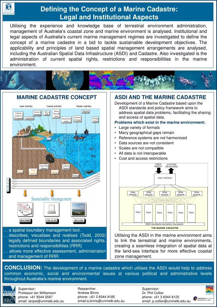
Defining the Concept of a Marine Cadastre: Legal and Institutional Aspects Utilising the experience and knowledge base of terrestrial environment administration, management of Australia’s coastal zone and marine environment is analysed. Institutional and legal aspects of Australia’s current marine management regimes are investigated to define the concept of a marine cadastre in a bid to tackle sustainable development objectives. The applicability and principles of land based spatial management arrangements are analysed, including the Australian Spatial Data Infrastructure (ASDI) and Cadastre. Also investigated is the administration of current spatial rights, restrictions and responsibilities in the marine environment. MARINE CADASTRE CONCEPT • ASDI AND THE MARINE CADASTRE • Development of a Marine Cadastre based upon the ASDI standards and policy framework aims to address spatial data problems, facilitating the sharing and access of spatial data. • Problems which exist in the marine environment: • Large variety of formats • Many geographical gaps remain • Reference systems are not harmonized • Data sources are not consistent • Scales are not compatible • All data is not interoperable • Cost and access restrictions … a spatial boundary management tool. …describes, visualises and realises (Todd, 2002) legally defined boundaries and associated rights, restrictions and responsibilities (RRR) … allows more effective assessment, administration and management of RRR. Utilising the ASDI in the marine environment aims to link the terrestrial and marine environments, creating a seamless integration of spatial data at the land-sea interface for more effective coastal zone management. CONCLUSION:The development of a marine cadastre which utilises the ASDI would help to address common economic, social and environmental issues at various political and administrative levels throughout Australia’s marine environment. Researcher: Andrew Binns phone: +61 3 8344 9185 email:a.binns@unimelb.edu.au Supervisor: Professor Ian Williamson phone: +61 8344 5597 email: ianpw@unimelb.edu.au Supervisor: Dr. Phil Collier phone: +61 3 8344 8125 email: p.collier@unimelb.edu.au