Download
1 / 60
600 likes | 802 Views
Country Overview - Estonia Mapping Activities in Statistics Estonia - II. Nordic Forum for GeoStatistics 12-14 September 2006, Norway, Kongsvinger Inge Nael , Marika Mäemets, Marge Rom Statistics Estonia. OFFICIAL STATISTICS ACT; STRATEGY 2007. § 2. Official statistics

E N D
Country Overview - EstoniaMapping Activities in Statistics Estonia - II Nordic Forum for GeoStatistics 12-14 September 2006, Norway, Kongsvinger Inge Nael, Marika Mäemets, Marge Rom Statistics Estonia
OFFICIAL STATISTICS ACT; STRATEGY 2007 • § 2. Official statistics • (1) Official statistics are aggregated and generalised information which is obtained as a result of collection and systematic processing of data from official statistical surveys. • (2) Official statistics reflect the economic, demographic, social and environmental situation of Estonia and changes occurring therein. • (3) Official statistics shall conform to the principles of impartiality, reliability, relevance, cost-effectiveness, confidentiality and transparency. • IV.More efficient IT coordination • Activities • To develop the use of geographical information systems in statistics 12.09.-14.09.2006; Nordic Forum for GeoStatistics
MAP APPLICATIONS AND SPATIAL DATA ANALYSES • INTERACTIVE MAP APPLICATIONS • web-based map applications • SPATIAL DATA ANALYSES (EXAMPLE) • Census based maps 12.09.-14.09.2006; Nordic Forum for GeoStatistics
INTERACTIVE MAP APPLICATIONS • USE OF LAND INFORMATION SYSTEM WEB MAP SERVICES • (e-Services) for presenting statistical data • e-Services for public use • e-Services for VAUs (Value Added Users) • MAP APPLICATIONS of STATISTICS ESTONIA • ADMINISTRATIVE-SETTLEMENT – Interactive map of administrative and settlement division • WASTE – Interactive map of waste treatment sites 12.09.-14.09.2006; Nordic Forum for GeoStatistics
LIS PUBLIC SERVICE SYSTEM in ENLB • Land Information System (LIS)- collects, maintains and makes accessible the official land related data (covering the whole republic) • The Public Service System is a tool for achieving one of Land Board´s main objectives, i.e. to provide the society with land related information • The Public Service System is a group of e-services based on the Land Board`s datasets and map server and it is offered via Internet 12.09.-14.09.2006; Nordic Forum for GeoStatistics
Third Party DB STRUCTURE OF WEB APPLICATIONS (SERVICES) Spatial Data From ENLB WEB Browser Master Application Map window Service User DB Spatial Data Other Data - alphanumeric 12.09.-14.09.2006; Nordic Forum for GeoStatistics
EXAMPLES OF e-SERVICES FOR PUBLIC USE in ENLB • Fully available to public • Cadastral Unit (CU) information query • Land Information Public Service as Land Data Wander • Service for Cultural Memorial Register • Interactive map of administrative and settlement division of Estonia • Interactive map of waste treatment sites • Available for special user groups • Nature protection objects service 12.09.-14.09.2006; Nordic Forum for GeoStatistics
BASIS AND OBJECTIVE OF CO-OPERATION • co-operation agreement of 28.11.2002 between the Estonian National Land Board and Statistics Estonia • administration and publishing of spatial data • presenting the relevant statistical data on maps over the Internet • significant is that in presenting mapped statistical information in an interactive form over the Internet, Statistics Estonia may use the relevant system developed by another state agency, the Land Board 12.09.-14.09.2006; Nordic Forum for GeoStatistics
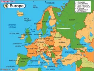
CO-OPERATION OF STATISTICS ESTONIA AND ESTONIAN LAND BOARD • In the framework of co-operation contract (non-monetary) in joint management (administering) of spatial data Statistics Estonia has an opportunity • to use web map server of Land Board • to create interactive map applications on the web map server • While creating map applications the following maps are used as background maps • Map of administrative and settlement divison (borders) of Estonia • Estonian Base Map 1:50 000 • Estonian Basic Map 1:10 000 • orthophotos (black-and-white and coloured) 1:10 000, 1:2 000 12.09.-14.09.2006; Nordic Forum for GeoStatistics
INTERACTIVE MAPS • Interactive map of administrative and settlement division • relates Estonian map with the classification EHAK and with legal acts via eRT on the alteration of administrative-territorial organisation (incl. change of status and/or territory of administrative units in the last year), statistics have been added http://www.stat.ee/150920 • Interactive map of waste treatment sites • relates the attribute data of waste treatment sites with their location on the map, general statistics on waste treatment sites have been added on Estonia, as well as on county and local government unit level http://www.stat.ee/164271 12.09.-14.09.2006; Nordic Forum for GeoStatistics
SPATIAL DATA AND MAP APPLICATIONS:POINT-BASED AND AREA-BASED MAP APPLICATIONS • Use of vector data • point-based data • map application WASTE • area-based data • map application ADMINISTRATIVE-SETTLEMENT 12.09.-14.09.2006; Nordic Forum for GeoStatistics
INTERACTIVE MAPS - DEVELOPMENTS • Interactive map of administrative and settlement division • new way of presentation of the classification EHAK on the web site of Statistics Estonia (changes in linking) • changes in presenting statistical information (frequency of recalculationsin relation with changes of administrative division as at 01.01.2006 • English version • Interactive map of waste treatment sites • further keeper of map application - Estonian Environment Information Centre • supplementing of the application with the up-to-date data 12.09.-14.09.2006; Nordic Forum for GeoStatistics
INTERACTIVE MAP OF ADMINISTRATIVE AND SETTLEMENT DIVISION • Interactive map of administrative and settlement division • relates Estonian map • with the classification EHAK and with legal acts via eRT • statistics have been added • as at 1.01.2005 and as at 1.01.2004 • the data of each subsequent year will be added at the beginning of the current year, the data as at 1.01.2006 are under preparing • the map layer of changes of administrative and settlement division (incl. change of status and/or territory of administrative units in the last year)can be displayed as a separate map layer • the statistical data will be updated according to the publication of new data of Statistics Estonia • Map application is in Estonian 12.09.-14.09.2006; Nordic Forum for GeoStatistics
INTERACTIVE MAP OF ADMINISTRATIVE AND SETTLEMENT DIVISION – LEGAL BASIS • Legal Basis • Territory of Estonia Administrative Division Act • Local Government Organisation Act • Land Cadastre Act • Official Statistics Act • Classification of Administrative and Settlement Units of Estonia (EHAK in Estonian) • List of Administrative and Settlement Units of Estonia 12.09.-14.09.2006; Nordic Forum for GeoStatistics
INTERACTIVE MAP OF ADMINISTRATIVE AND SETTLEMENT DIVISION - ACCESS • The public have an access to the service from the 1st quarterof 2005 through the home pages of • Statistics Estonia • http://www.stat.ee • Estonian National Land Board • http://www.maaamet.ee 12.09.-14.09.2006; Nordic Forum for GeoStatistics
Initial view of map application 12.09.-14.09.2006; Nordic Forum for GeoStatistics
Map layer “Local governments”- attribute information window 12.09.-14.09.2006; Nordic Forum for GeoStatistics
Map layer “Changes of status and/or territory of administrative units,2003” - attribute information window 12.09.-14.09.2006; Nordic Forum for GeoStatistics
Map layer “Settlements” 12.09.-14.09.2006; Nordic Forum for GeoStatistics
Search by name of administrative or settlement unit 12.09.-14.09.2006; Nordic Forum for GeoStatistics
INTERACTIVE MAP OF ADMINISTRATIVE AND SETTLEMENT DIVISION - DEVELOPMENTS • Interactive map of administrative and settlement division • new way of presentation of the classification EHAK on the web site of Statistics Estonia (changes in linking) • changes in presenting statistical information (frequency of recalculationsin relation with changes of administrative division as at 01.01.2006) • English version 12.09.-14.09.2006; Nordic Forum for GeoStatistics
INTERACTIVE MAP OF WASTE TREATMENT SITES • Relates the attribute data of waste treatment sites with their location on the map, general statistics on waste treatment sites have been added on Estonia-, as well as on county- and local government unit level • http://www.stat.ee/164271 12.09.-14.09.2006; Nordic Forum for GeoStatistics
INTERACTIVE MAP OF WASTE TREATMENT SITES – AIM AND LEGAL BASIS • THE AIM AND LEGAL BASIS DATA • The aim of the map application Waste is to make available to the user the data of the “Statistical Inventory of Landfills and Waste Treatment Sites” conducted in 2003 on the basis of interactive map application • Regulation (EC) No 2150/2002 of the European Parliament and of the Council of 25 November 2002 on waste statistics serves as a legal basis for the “Statistical Inventory of Landfills and Waste Treatment Sites” 12.09.-14.09.2006; Nordic Forum for GeoStatistics
INTERACTIVE MAP OF WASTE TREATMENT SITES – DATA AND LANGUAGES • THE DATA AND LANGUAGES • Map application provides general data of waste treatment sites by point objects as well as by administrative division • The map application Waste connects the attribute data of waste treatment sites with their location on the map • General statistics of waste treatment sites on Estonia as a whole, by counties and local government units have been added • Map application is in Estonian and in English 12.09.-14.09.2006; Nordic Forum for GeoStatistics
INTERACTIVE MAP OF WASTE TREATMENT SITES - THE DATA TYPES • Map application contains the following data: • ·locations of waste treatment sites as point objects together with attribute information including the name of object, administrative origin, type, kind, activity and comments collected in the course of ”Statistical Inventory of Landfills and Waste Treatment Sites” in 2003 • ·borderlines of Estonian administrative and settlement division, as at 01.01.2004 • ·general statistics of waste treatment sites on Estonia as a whole, by counties and local government units • ·legal acts related to waste treatment • ·background maps (basic map, base map) and orthophotos 12.09.-14.09.2006; Nordic Forum for GeoStatistics
INTERACTIVE MAP OF WASTE TREATMENT SITES - THE TYPES AND CLASSES OF POINT OBJECTS • Two types of waste treatment sites (573): type 1 - landfills(430) Classes of landfills (3) • The indicator of activity of waste treatment sites: • operatinglandfills (56) • closedlandfills (374) type 2 – animal waste burial sites (143) • operating(15) • closed(128) 12.09.-14.09.2006; Nordic Forum for GeoStatistics
INTERACTIVE MAP OF WASTE TREATMENT SITES - THE STRUCTURE OF MAP APPLICATION • The map layers • territorial division (Estonia, counties, local municipalities, settlements, background – Estonian Base Map, Estonian Basic Map, ortophotos (1:10 000; 1:2 000) • objects by types and classes • objects by activity • The active information layers according to the map layers • alpha-numeric information of objects • Activities • search by location of objects, overview window • printing options • Metadata • legal acts • information of background maps • User guide 12.09.-14.09.2006; Nordic Forum for GeoStatistics
INTERACTIVE MAP OF WASTE TREATMENT SITES - ACCESS TO THE MAP APPLICATION (ENGLISH VERSION) • Map application can be opened as follows: • on the web site of the Statistics Estoniawww.stat.ee under the sub-heading “Maps” of the heading “Statistics” through the link Interactive Map of Waste Treatment Sites • on the web site of the Estonian Land Board www.maaamet.ee under the heading “Web Map Server” through the link • Open Interactive Map of Waste Treatment Sites • on the web site of the Estonian Environment Information Centre: • http://www.keskkonnainfo.ee/english/waste 12.09.-14.09.2006; Nordic Forum for GeoStatistics
Initial view of map application 12.09.-14.09.2006; Nordic Forum for GeoStatistics
Waste treatment sites – operating landfills 12.09.-14.09.2006; Nordic Forum for GeoStatistics
Waste treatment sites – closed landfills 12.09.-14.09.2006; Nordic Forum for GeoStatistics
Animal waste burial sites – operating and closed 12.09.-14.09.2006; Nordic Forum for GeoStatistics
Administrative and waste treatment sites statisticsLocal governments – attribute information window 12.09.-14.09.2006; Nordic Forum for GeoStatistics
Background map – Estonian Base MapActivities – overview window 12.09.-14.09.2006; Nordic Forum for GeoStatistics
Background map – orthophoto (1:10 000)Operating landfills - attribute information window 12.09.-14.09.2006; Nordic Forum for GeoStatistics
Background map – Estonian Basic MapActivities – search window 12.09.-14.09.2006; Nordic Forum for GeoStatistics
Intermediate result window of searchSearch by name of county 12.09.-14.09.2006; Nordic Forum for GeoStatistics
Search result by name of countySelected object is Kohtla-Järve (ash field) 12.09.-14.09.2006; Nordic Forum for GeoStatistics
Info – menu of metadata 12.09.-14.09.2006; Nordic Forum for GeoStatistics
INTERACTIVE MAP OF WASTE TREATMENT SITES - DEVELOPMENTS • Interactive map of waste treatment sites • further keeper of map application - Estonian Environment Information Centre • supplementing of the application with the up-to-date data 12.09.-14.09.2006; Nordic Forum for GeoStatistics
CENSUS MAPS AND CENSUS ADDRESS FILES Problems of updating • Abbreviations • Census Map – CM; • Basic Map – BM; • Estonian Topographic DataBase – ETDB; • DataBase – DB; • Local Municipality – LM • Building Register – BR; • Statistical Profile – SP; • Economic Unit – EcU; • Census Address File - CAF 12.09.-14.09.2006; Nordic Forum for GeoStatistics
Supplementation and updating of database of digital census maps– analysis Testing area: Lääne-Viru county in 2003 • TerritoryArea, Population Population Number Number • % sq kmsizedensity of of • (inhabitants)(inhabitants cities rural • per sq km) municipalities • ESTONIA 45 227.6 1 370 052 30.3 42 205 • LÄÄNE-VIRU 3 464.6 67 801 19.6 4 14 • COUNTY • SHARE OF 7.66% 4.95% 9.5% 6.8% • LÄÄNE-VIRU • COUNTY • Abbreviations • Census Map – CM; Basic Map – BM; Database – DB;Local Municipality – LM • Building Register – BR; Statistical Profile – SP; Economic Unit – EcU; • Census Address File - CAF 12.09.-14.09.2006; Nordic Forum for GeoStatistics
THE AIM OF TESTING • To analyse by comparison of geographical location and address which buildings (objects) in the other data sources are located on CM • On basis of which data sources it is possible to complement the CM(to add objects(buildings) from BM, from SP (enterprises and social organisations) • Comparison of geographical location of buildings based on co-ordinates and using the 10m buffer as well as the comparison based on the exact addresses of buildings using also the type of building, the name of owner, the code of cadastral unit, the numer of dossier of BR • Cooperation with LM -the dissemination of CM to LM (cities and rural municipalities) on the basis of temporary licence agreement 12.09.-14.09.2006; Nordic Forum for GeoStatistics
Why are we making this test ? • Two reasons: • To provide for Censuses an updated and complete digital map on the building level (for planning, for field works, for output) • For the current statistics, to link the statistical objects with the map for location-based analysis of statistical indicators (incl. point-based analysis) • Thus: • The need to improve and update digital CM using digital information from other data sources without conducting expensive field works • The developed BR will be linked to BM, all objects in BR will be linked to the polygon of building on the BM and the respective co-ordinates will also be saved in BR, consequently, CM can be improved on the basis of BR • The updating of BM by the Land Board will be carried out every five years • The updating of information on roads by the National Road Administration - road register is updated every year only for state roads based on Base Map (1 : 50 000) with graphical interface but for local roads there is no register and no graphical interface at the moment 12.09.-14.09.2006; Nordic Forum for GeoStatistics
Comparable data sources of Census Maps and of other institutions • Data sources in Statistics Estonia • 1. IT Department GIS section • Basis : Census Map of the 2000 Population and Housing Census (buildings are connected with the list of inhabitants) • In urban areas – co-ordinates of centroids of buildings and exact addresses for residential buildings (name of settlement, name of street, number of house); field works – 1999 • In rural areas – centroids of residental buildings in the farm and unique reference numbers of farms within the village and in addition (name of farm, name of owner); field works 1998 – 1999 • Updating : • Version improved by enumerators - 1st quarter of 2000 • Version of updated centroids – 4th quarter of 2002 • Urban areas by Regio Ltd • Rural areas by Estonian Mapping Centre Ltd 12.09.-14.09.2006; Nordic Forum for GeoStatistics
2. Enterprise Statistics Division • Statistical profile • Economic units (EcU) : • Addresses -data received in 1st q 2003 • in urban areas – exact address; • in rural areas – address on the settlement level • Name and economic activity of economic unit - data received in 3rd q 2003 • Population and Social Statistics Division • Data received from (this information has not yet been analysed) : • Ministry of Education – the list of schools with addresses - 3rd q 2003 • Ministry of Social Affairs – the lists of social welfare institutions, shelters, children’s homes and hospitals with addresses - 3rd q 2003 (data about 2002) 12.09.-14.09.2006; Nordic Forum for GeoStatistics
Comparable data sources of other institutions • Ministry of the Environment • Land Board - Basic Map (BM) of Estonia (1:10 000) • - polygon (co-ordinates) of building and address (in towns – exact address; in rural areas – address on the settlement level, in some cases with the name of farm)Field works 1995-1996; data received in 2nd q 2003 • Ministry of Economic Affairs and Communications • Building Register (BR) – addresses of buildings (partly with numbers of farms) and type of building and name of owner; data received in 1st q 2003 • Supporting systems and legal acts(as at 2003 2nd q) • State Dwelling and Building Register and the Register of Constructions are transformed in to the one register and renamed as Building Register starting from 01.01.2004 • The draft of the regulation on the System of Address Data will enter into force on 01.01.2004 and the address databases should conform to the regulation by 01.07.2004 • The draft of the System of State Databases Act will enter into force on 01.01.2004 • The new version of the Personal Data Protection Act will enter into force on 01.10.2003 12.09.-14.09.2006; Nordic Forum for GeoStatistics
Information from different data sources originates from different time periods (CM and BM, SP, ministries) • In rural areas the exact address of building is missing, usuallythe address is available only on the settlement level (BR, BM, SP) • Information is not complete (BR, BM) • Different data sources use different classifications (CM, BM, BR) for the differentiation of residential, social and outbuildings • For rural areas, perhaps it is necessary to change the background map (Estonian Base Map 1:50 000) of CM into the new background map (Estonian Basic Map 1:10000) • The making of town maps and their updating is not regulated by Land Board • The use of CM by the LM is problematic due to shortage of software and qualified staff, the map scale is not good for multipurpose use, the map information is not updated, not linked to registers, the address standard is missing • The formation of Census Address File(CAF): to specify the new structure, to estimate the quality of the existing CAF, the high precision of geo-coding for co-ordinate address, to find co-operation partners, to work out the methodology of updating, timetable, info-technological environment taking into account the international experiences Problems - Which types of buildings are preserved and updated on CM ? 12.09.-14.09.2006; Nordic Forum for GeoStatistics
Results of comparison • CM&BM: If the geographical location of building is the same then we can add the address from BM to the CM DB • CM&BR: If the building is on the CM then we can add the type of building to CM DB. In the future when the BR includes the co-ordinates of buildings we can add the new buildings into the CM • CM&SP: If the building is on CM we can add the additional information about enterprises into CM • CM&LM: About 1/3 of LM is using the CM and about 20% have made proposals for the updating of CM such as : • - to link CM to cadastral map (1:10000); to update information on roads and other background information; to improve and update information in BR; to co-operate with LM in the updating of CM based on regular checking of information or regular provision of information on LM; to establish regular updating procedure via BR based on common web-based interface for all municipalities, some towns have also proposed to update the mapsthemselves 12.09.-14.09.2006; Nordic Forum for GeoStatistics
Comparison of CM with Estonian Basic Map (BM) Comparison of geographical location of buildings: Which buildings shown on BM are on CM ? Number of buildings : CM – 27555 Number of buildings : BM – 47 907 Of which : 13 576 - centroid of CM is insidethe polygon of building on BM 34 331 - centroid of CM is not inside the polygon of building on BM Of which:5603 - building on BM is inside of the 10 m buffer of the centroid of building on CM 28 728 – building on BM is outside of polygon and buffer of building on CM 12.09.-14.09.2006; Nordic Forum for GeoStatistics