Download
1 / 57
570 likes | 684 Views
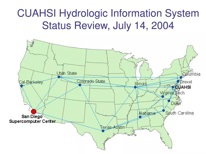
CUAHSI Hydrologic Information System Status Review, July 14, 2004. Agenda. Review the work of the five project partners CUAHSI (Rick Hooper, Jon Duncan) San Diego Supercomputer Center (John Helly, ….) University of Texas (David Maidment, …) University of Illinois (Praveen Kumar ….)

E N D
CUAHSI Hydrologic Information SystemStatus Review, July 14, 2004
Agenda • Review the work of thefive project partners • CUAHSI (Rick Hooper, Jon Duncan) • San Diego Supercomputer Center (John Helly, ….) • University of Texas (David Maidment, …) • University of Illinois (Praveen Kumar ….) • Drexel University (Michael Piasecki…) • Involving the collaborators: V. Lakshmi, X. Liang, Y. Liang, U. Lall, L. Poff, K. Reckhow, D. Tarboton, I. Zaslavsky, C. Zheng • HIS review meetings • SDSC (August 12-13) – technical detail • Logan (August 23) – user needs assessment
Agenda • Review the work of thefive project partners • CUAHSI (Rick Hooper, Jon Duncan) – Neuse HO report status • San Diego Supercomputer Center (John Helly, ….) • University of Texas (David Maidment, …) • University of Illinois (Praveen Kumar,...) • Drexel University (Michael Piasecki,…)
Agenda • Review the work of thefive project partners • CUAHSI (Rick Hooper, Jon Duncan) – Neuse HO report status • San Diego Supercomputer Center (John Helly, ….) • University of Texas (David Maidment, …) • University of Illinois (Praveen Kumar ….) • Drexel University (Michael Piasecki…)
Hydrologic Information SystemOverview and Status John Helly San Diego Supercomputer Center hellyj@ucsd.edu
Outline • SDSC HIS Team • HISArchitecture • HydroViewer GUI • Metadata Content Standard & Controlled Vocabulary • Harvesting Metadata and Data • External Interfaces • Proposal Tasks • Community Coordination
SDSC HIS Team • John Helly / Co-PI, HIS Developer • Don Sutton / HIS Developer • Tiffany Houghton / HIS Developer • Ilya Zaslavsky / GIS / GEON • Arcot Rajasekar / SRB • Josh Polterock / Web-service Support • Dave Archbell / Oracle DBMS Support
Empirical-to-Conceptual e.g., ArcHydro e.g., Hydrologic Cycle Data Models Reference Models Data Models Reference Models Data Models Conceptual Reference Models Data Transformation Federated Digital Library Harvesting Distributed Data Sources Distributed Data Sources Distributed Data Sources Distributed Data Sources
HOi HOi HOi HOi HOi HOi Empirical-to-Conceptual e.g., ArcHydro e.g., Hydrologic Cycle Data Models Reference Models Data Models Reference Models Data Models Hydrologic Observatories Federated Digital Library Data Transformation Center for Hydrologic Information Harvesting Harvesting Distributed Data Sources Distributed Data Sources Distributed Data Sources Distributed Data Sources Distributed Data Sources Distributed Data Sources Distributed Data Sources Distributed Data Sources
System Architecture: Hardware GeonGrid Node cuahsi001.sdsc.edu SDSC Web-service cuahsi.sdsc.edu SRB/HPSS SRB/SAMFS File System High-speed Communications Oracle Metadata Catalogue
Network Architecture Neuse Federated MCAT SMR
HydroViewer GUI Neuse River Watershed Collection
HydroViewer GUI Santa Margaria River Watershed Collection
Wide Range of Data Presentation Example from SIOExplorer Collections User Desktop
Metadata Template File (*.mtf) Defines *.mif Content <" label“>,<attribute_name>,<“value“>,<“data type“>,<“associates“>,<“authority”> "Publisher",mif_dbc_publisher,"character","required","0","germ" "Title",mif_dbc_title,"character","required","0","germ" "Creator",mif_dbc_creator,"character","required","0","germ" "Subject",mif_dbc_subject,"character","required","0","germ" "Description",mif_dbc_description,"character","required","0","germ" "Publisher",mif_dbc_publisher,"character","required","0","germ" "Contributor",mif_dbc_contributor,"character","required","0","germ" "Date",mif_dbc_date,"character","required","0","germ" "Type",mif_dbc_type,"character","required","0","germ" "Format",mif_dbc_format,"character","required","0","germ" "Identifier",mif_dbc_identifier,"character","required","0","germ"
Interoperability Coordination • GEON Weekly Meetings • Interoperability Workshop • Sediment Chemistry Workshop
HIS Services • Digital Library • Search and retrieval • Metadata tools • Data Format Transformation • Remote Computation • Gridded computing resources
Latest Progress • Telecon (John) with Drexel(Luis) and UT(David) • Discussed utilization of XML for unit conversion • Telecon (John) with Berkeley and Virginia Tech • Focus on VT implementation and interface definition • Need similar conversation with UT/Austin • MTF standardization (Don, John) • http://cuahsi.sdsc.edu/html_source/metadata_resources.html • MOBE and COBE hardening (Tiffany) • Needed for network testing (John) • Collection-building standardization (Don, John) • REST/SOAP interface (Ilya, Reza, Don) • SRB 3.2 installation testing and regularization (John, Raja) • MultiViewer based on REST/SOAP interface being investigated (Ilya, Don, Reza) • GEON-registration of HIS collections being investigated (Ilya, Don, Reza) • OWL file expressed as interactive graph (*.svg) coming up (Ilya) • Web-interface for managing files • *.mtf-specified schema provides vocabulary • Need controlled-vocabulary • Bottom-up versus top-down interface • Coordination with Drexel needed
Agenda • Review the work of thefive project partners • CUAHSI (Rick Hooper, Jon Duncan) – Neuse HO report status • San Diego Supercomputer Center (John Helly, ….) • University of Texas (David Maidment, …) • University of Illinois (Praveen Kumar ….) • Drexel University (Michael Piasecki…)
University of Texas • David Maidment is PI, assisted by Jon Goodall, Gil Strassberg, Venkatesh Merwade • Hydrologic data model development • atmospheric water, surface water, subsurface water • interoperable analysis environment
HIS Data Organization Hydrologic Analysis and Visualization Environments Simulation model Visualization Analysis Statistics Hydrologic Representation Environment (Sets of variables defined on space-time domains) Hydrologic Data Model Hydrologic Digital Library (Digital files of hydrologic information in any form, indexed by a metadata catalog)
Continuous Space-Time (b) Vertical cross-section (a) Precipitable water in the atmosphere (c) Wind speed (colors) and wind vectors Use NetCDF for continuous space-tme
Discrete Space-Time A South Florida Basin Flow In cfs Rain in/d ET mm/d Flow Out cfs Flow Out cfs We need to link time series to spatial objects to define the transfer of water into and out of the object. Use Arc Hydro for discrete space-time
Hydrologic Flux Time Objects TS Object TS Operator +, - , etc. TS Object TS Object TS Object TS Object Class is based on the Arc Hydro TimeSeries Component. TS Operator Class performs time series transformations to allow addition, subtraction, integration, etc of different TS Objects.
Unit Conversions From Unit To Unit From Unit SI Units To Unit To Unit From Unit 2n Must read two conversion factors from xml file What about exact conversions like feet to mile?
XML for Unit Conversions We will have to define our hydrologic data model in XML to make it application and vendor independent
FEMA Data for Neuse Half square mile catchments 3D streams and cross-sections 5600 km of streams and rivers mapped and modeled for floods
Neuse Basin: Coastal aquifer system Section line Beaufort Aquifer * From USGS, Water Resources Data Report of North Carolina for WY 2002
Creating a 3D model of the subsurface Stratigraphy from the North Carolina database (tabular), imported into ArcGIS
Importing borehole data to GMS Data is imported from GIS into GMS (Groundwater Modeling System)
Solid model Solids are generated in GMS using the Horizons method Contacts are assigned horizons (from bottom to top) and then solids are created by interpolating a surface for each horizon extruding downward.
Cross section views Can create cross sections from the solids or by connecting observation at boreholes. Next we want to read back the cross sections and solids into GIS
Agenda • Review the work of thefive project partners • CUAHSI (Rick Hooper, Jon Duncan) – Neuse HO report status • San Diego Supercomputer Center (John Helly, ….) • University of Texas (David Maidment, …) • University of Illinois (Praveen Kumar ….) – Praveen is overseas… • Drexel University (Michael Piasecki…)
University of Illinois • Praveen Kumar is PI, assisted by Benjamin Ruddell • Developing “Modelshed” which is an generalized hydrologic modeling and data analysis environment built on top of Arc Hydro • Focused on applications integrating hydrology and climate modeling
Drainage System Hydro Network Flow Time Time Series Hydrography Channel System Arc Hydro Components
What is a Modelshed? • A volumetric spatial model unit, registered in three dimensions by a GIS, with which time-varying data, model fluxes, spatial relationshipsand descriptive metadata are associated
Agenda • Review the work of thefive project partners • CUAHSI (Rick Hooper, Jon Duncan) – Neuse HO report status • San Diego Supercomputer Center (John Helly, ….) • University of Texas (David Maidment, …) • University of Illinois (Praveen Kumar ….) – Praveen is overseas… • Drexel University (Michael Piasecki…)
Drexel University • Michael Piasecki is PI, assisted by Luis Bermudez • Goal is to study metadata languagesand standards to find what is most suitable for hydrology • Concept hierarchies stored in “ontologies” described in OWL (Ontology Web Language)
Comparison of time schemes for geospatial data by Bora Beran - Saiful Islam
Motivations Metadata standards ISO 19115 – Geographic Information metadata CSDGM (FGDC) - Content Standard for Digital Geospatial Metadata (CSDGM) DCMI –Dublin Core Metadata Standard Markup Languages EML – Ecological Metadata Language ESML –Earth Science Markup Language GML – Geographic Markup Language XML – Extended Markup Language Self describing documentation format mif – Metadata Interchange Format netCDF – Network common Data Format GRIB –GRIdded Binary HDF – EOS - Hierarchical Data Format - Earth Observing System geoTIFF - Georeferenced Tag(ged) Image File Format DIF – Directory Interchange Format
CSDGM (FGDC) - What do they offer? FGDC Temporal Metadata Package: The simplest of all But is simplicity a drawback? Depends on the purpose We’ll see if these elements are enough for sufficiently expressing hydrologic data.
Ecological markup language temporal Coverage • Two main components similar to FGDC • Single Date + Time • Range Date + Time • Additionally supports alternate time scale, e.g. geological time scale • Reference of temporal coverage Similar to FGDC
Earth Science Markup Language way Lacks time scale information This part is same as FGDC Adds a separate option for periodic occurrences.