Download
1 / 22
300 likes | 624 Views
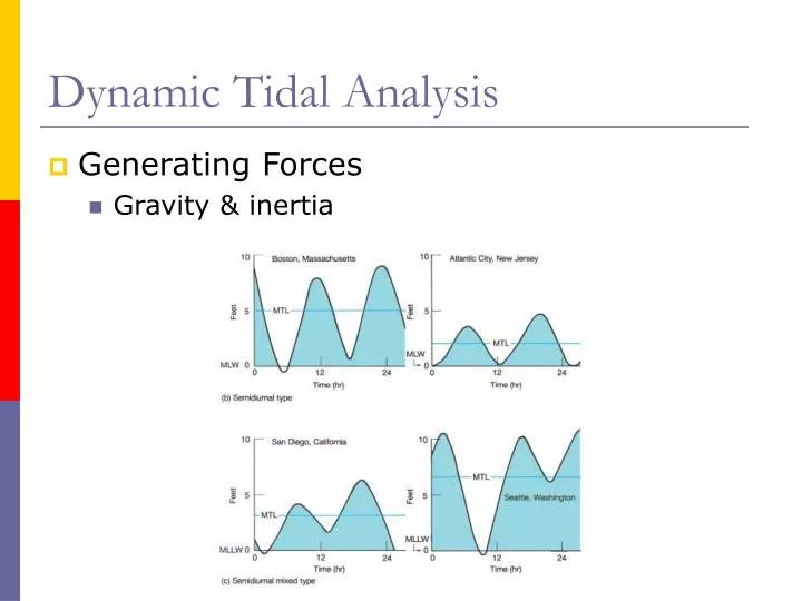
Dynamic Tidal Analysis. Generating Forces Gravity & inertia. The Tide Wave. The Tide Wave. Free wave ~200 m/sec Forced wave at the equator Balance between friction & gravity Less in higher latitudes. Tide wave that moves, or progresses, in a nearly constant direction

E N D
Dynamic Tidal Analysis • Generating Forces • Gravity & inertia
The Tide Wave • Free wave • ~200 m/sec • Forced wave at the equator • Balance between friction & gravity • Less in higher latitudes
Tide wave that moves, or progresses, in a nearly constant direction Western North Pacific Eastern South Pacific South Atlantic Ocean Progressive Wave Tides
Cotidal lines Marks location of crest at certain time intervals 1 hour Shallow water wave Progressive Wave Tides
Standing Wave Tides • The reflection of the tide wave can create a rotary standing wave
The bulge on the western edge of the basin creates a pressure gradient (to the east) as the earth continues to rotate At some point the water will flow down the pressure gradient and be deflected to the right in the Northern Hemisphere.
Due to the Coriolis effect the water forms a mound in the South • This bulge creates another pressure gradient (to the north) • When the water flows it is deflected once again to the right and piles up in the eastern margin
Once this balance is reached the tidal bulge that forms is called a rotary wave • This wave is similar to the wave that can be produced by swirling a cup • A rotary wave creates both high (crests) and low (troughs) tides each day
Rotary Wave Movement The node is seen half-way along the basin, where the color is always greenish-yellow regardless of the phase of the wave.
Tide crest rotates counterclockwise around the basin Tidal current rotates clockwise because the current is deflected to the right in the Northern Hemisphere
Amphidromic Point • Node for a rotary wave • Tidal range is zero • Tidal range increases away from node
Corange Lines • Lines of equal tidal range
Rose Diagram • Shows direction of tidal current at a specific hour • Speed of current correlated to length of arrow
Progressive-Vector Diagram • Diurnal • One complete circle • Semidiurnal • Two circles • Mixed • Two unequal circles
Tides in Small & Narrow Basins • Tides can be quite different due to the shallowness, smallness and shapes of many bays and estuaries
In the nearby Bay of Fundy it is much narrower and more elongated (restrictive basin) the tidal wave cannot rotate as it does in the open ocean • Instead the tide moves in and out of the estuary and does not rotate around a node
The Bay of Fundy • Two reasons: • Gradual tapering & shallowing that constricts tidal flow into the bay • Dimension of the bay • Tidal resonance • This creates a seiche causing the water to slosh back and forth like a standing wave
Tidal Bores • High tide crest that advances rapidly up an estuary or river as a breaking wave • 3 conditions contribute to tidal bores • Large tidal range, greater than 17 feet • A tapering basin geometry • Water depths that systematically decrease upriver
Tidal Bores • Qiantang River • 9m • 40 km/hr (25 miles/hr) • Amazon River • Pororoca