Download
1 / 120
1.2k likes | 1.44k Views
PLACE Tool Kit. Protocol Decisions. Presentation to the PLACE National Steering Committee. Presenter name and degree here Your organization here f Date of presentation Name of meeting. 1. Study Summary. Study summary.

E N D
PLACE Tool Kit Protocol Decisions Presentation to the PLACE National Steering Committee Presentername and degree here Your organization here f Date of presentation Name of meeting
Study summary The study summary (1 page) provides key information to stakeholders. It will be based on the protocol decisions, and will cover the following: • Study aim • Study areas: Where PLACE will be implemented • Study design and methods • Number and type of participants • Key outputs and indicators • Study leadership and funding Note: It is completed AFTER protocol decisions are made.
Review aim The aim of the Priorities for Local AIDS Control Efforts (PLACE) method is to increase local capacity to understand the drivers of local HIV epidemics, identify gaps in services among those most likely to acquire and transmit HIV, and provide evidence to support tailored interventions to reduce HIV transmission and improve access to treatment.
Review and confirm objectives • To identify “priority prevention areas” (PPAs) • To identify public social venues where people meet new sexual (or needle-sharing) partners • To visit, describe, map, and assess the availability of HIV prevention services at these venues • To measure indicators of HIV infection status, population size, transmission risk, and access to HIV prevention and treatment services among key and priority populations at venues • To estimate HIV prevention and treatment cascades • To engage with local stakeholders to use the data to improve programs
Terms used in setting objectives • Priority prevention areas: Geographic areas expected to have higher incidence of HIV • Key population: Populations most at risk of acquiring and transmitting HIV by sex or needle sharing • HIV treatment cascade: A bar graph of the number of people who are HIV-positive and on treatment, and who have achieved viral suppression • HIV prevention cascade: Bar graphs showing the number of those who need HIV prevention services, the number who have access to services, and the number who use the service consistently
Prioritize key indicators and subgroups Indicators • HIV prevalence • Population size • HIV treatment cascades • HIV prevention cascades • Risk behavior and program coverage Subgroups • Men • Women • Female workers • Youth 15-24 • Female sex workers* • Men who have sex with men (MSM)* • People who inject drugs* • Transgender women* • Others * May require oversampling for precise estimates
Tool to clarify rationale and objectives Purpose of “Worksheet 2.1. PLACE Objectives: Identification of Gaps that PLACE Could Address” • To specify the rationale for PLACE • To identify the gaps in strategic information that the PLACE study could address. • To specify objectives based on the gap analysis.
How to set priorities for PLACE • Use Worksheet 2.1 to set priorities for PLACE • Review the strategic information question and determine if there is a gap. • Review the relevant PLACE objectives and determine if each one is high-, medium-, or low-priority. • Reach consensus on whether the objective should be included.
Example: Where is HIV transmission most likely to occur ? • Do you know in which areas in the country HIV transmission is most likely to occur? • If there is a gap in strategic information, do you want to identify priority prevention areas in the country using the PLACE method? • If the answer is yes, can you confirm this objective of the PLACE study? There are 7 questions to answer on Worksheet 2.1. Answering these questions will shape the PLACE protocol.
Small-group work • Everyone should review the questions on Worksheet 2.1 and answer for each area: • Whether the topic is a gap • What the priority is for addressing the gap (high, medium, or low) • Come back together to discuss your responses and confirm the objectives.
Stakeholder documentation • To clarify study leadership, establish an ethical review process, and document stakeholder engagement to ensure full engagement of all affected people, including key populations and priority populations • Worksheets • 3.1 Stakeholder Engagement • 3.2 National Steering Committee Members • 3.3 Core Implementation Team Members • 3.4 District Steering Committee Members • 3.5 District PLACE Study Team Members
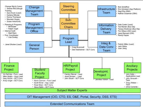
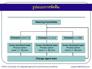
Identify leadership Describe the recommended organizational structure that will be used for PLACE implementation and describe the role of the National and District Steering Committees and their members.
National Steering Committee • The National Steering Committee oversees the design and implementation of PLACE, and the dissemination of the findings. The National Steering Committee is established in collaboration with government, funding organizations, and stakeholders. • Members are representatives from civil society, nongovernmental organizations, donors, people conducting surveillance, and advocacy groups.
National Steering Committee members Use this slide to identify the names of the National Steering Committee members.
Ethical review process • Engagement includes engagement with ethical and technical review committees. • List committees that will formally review the protocol. This may include scientific review as well as ethical review. • Plans for seeking ethical review should be described now. • It may be appropriate to request an exemption from full ethical review if the findings will be used primarily for program improvement.
Ethical implementation Even if the protocol is exempt from full ethical review, ethical implementation requires the following: • That potential participants are given information about the study, including the risks and benefits of participation • That participation is voluntary and can be stopped at any time • That HIV test results are provided along with linkage to care, if indicated • That maps and data are stored securely, and the confidentiality of participants is honored
Where to implement PLACE? • Background: In preparation for this National Steering Committee meeting, the Core Implementation Team will have identified the geographic framework for the country and met with key people to synthesize HIV epidemic indicators in a spreadsheet. • Key strategic indicators may have already been mapped using the PLACE QGIS software or some other spatial analysis tool. • The data and maps are used to better understand the drivers of the HIV epidemic, select areas to implement PLACE, and provide a spatial platform to interpret PLACE results and to create coverage maps.
Overview • Review Sample Protocol, Section 4. • Identify and document the geographic framework. • Obtain spatial data for administrative levels. • Compile district-level surveillance, population, and program data in the district summary spreadsheet. • Review contextual factors to identify a typology of priority prevention areas (PPAs). • Produce district-level maps. • Select areas to implement PLACE.
Adapt geographic framework The framework should be adapted to the country and should include the administrative areas in purple. This example is for a study that will select districts (both metropolitan districts and others).
Obtain spatial data (the “shapefiles”) for administrative levels • Consult with spatial analysis experts to obtain spatial data for the country. • The PLACE QGIS tool contains information for 14 selected countries: • Kenya • Malawi • Mozambique • Rwanda • South Africa • Tanzania • Uganda • Angola • Burundi • Côte d’Ivoire • Democratic Republic of the Congo • Eswatini (formerly Swaziland) • Ghana • Haiti
Compile and map district-level epidemiologic and program data Compile available district-level surveillance of population and routine program indicators, including: • HIV prevalence, by age, sex, and population group • Prevention of mother-to-child transmission (PMTCT) prevalence estimates for pregnant women • Number of people living with HIV, syphilis, and tuberculosis • Number on antiretroviral therapy (ART) • Number on ART not achieving viral suppression • Key-population size estimates • General population size • Program coverage indicators
Identify contextual factors • In addition to epidemic indicators based on surveillance, demographic features, and routine program data, the Core Implementation Team identifies contextual factors that may signal the location of PPAs. • These can be mapped using the QGIS PLACE Mapping Tool and used to prioritize districts for PLACE implementation. • Based on their investigation, the Core Implementation Team proposes a typology of PPAs that should be reviewed and finalized by the National Steering Committee. • See Worksheet 4.3 in the Protocol Decisions Manual. • Example to the left is a generic typology of PPA
Update geographic framework with PPAs The framework should be adapted to the country and should include the administrative areas in purple and PPAs in teal.
Use the QGIS PLACE Mapping Tool • The PLACE Mapping Tool is designed to help you map strategic information at the district level and use the information to select where to implement PLACE.
Use Scorecard tool to select districts under Option C • One option for selecting a probability sample of districts is to select criteria to score districts and sort the districts into high-, medium-, and low-priority categories, based on the district scores. • Then randomly sample in each stratum. • A spreadsheet tool is provided to select districts using this approach.
Example: PLACE Uganda 2013 In Uganda, a decision was made to implement PLACE in 25 districts. Option C was used with a scorecard. Then a computer program was used to select districts, oversampling districts with the highest scores but ensuring that all four regions were sampled.
Uganda 2013 Scorecard (1) The scoring system included 10 items, reflecting surveillance data, population size, and contextual factors. Points were given based on the following: • 1 point if the district was on a major transport route with a long-distance truck stopover • 1 point if it was a border district with a major border crossing • 1 point if the district had a municipality or above (reflects larger population/urban center) • 1 point if the district had two or more fishing villages (fishing villages have higher HIV prevalence) • 1 point if the district had mobile employment clusters evidenced by having at least one fishing village, mine, military camp, road construction, or major plantation
Uganda 2013 Score Card • 1 point if the district had sites with PMTCT data showing prevalence among pregnant women 15 to 24 >=10% • 1 point if there was low coverage for medical services based on discussions with the Ministry of Health • 1 point if the district had the top 10% of the HIV burden in the region • 1 point if 10% of mothers with HIV in the region lived in the district (from PMTCT data) • 1 point if there was evidence of a substantial increase in HIV prevalence Districts were sorted into high-, medium-, and low-priority strata based on their scores. In each stratum, a random sample was selected, with oversampling from high- and medium-priority strata.
Document decision on where to implement PLACE • Document the Geographic Framework • Save copies of any maps of surveillance data, program data, and/or contextual factors such as fishing villages and border crossings • Document the chosen option for selecting areas: A, B, or C • Document scoring system, if used • Select areas and document them along with the selection probability for each.
Identify option used and map selected districts Action: Identify option and map selected districts • In this example, districts were chosen using Option C. • Each selected area was mapped, and the probability of its selection was documented on a spreadsheet.
Conduct district entry visits • After the districts have been selected, a team should visit each one to determine if it is willing to participate and to establish the District Steering Committee.
Readiness assessments (1) Readiness assessments in each district have these aims: • Assess district support for PLACE • Engage key populations to assess their support and to determine whether harms could arise if PLACE were implemented. • Identify strategies to mitigate risks or dangers The National Steering Committee may want to attend some of the readiness assessments and/or may want to lead a national-level readiness assessment.
Readiness assessments (2) PLACE readiness assessments determine the appropriateness, readiness, and safety of conducting PLACE within a district. The Protocol Decisions Manual and its supplementary materials in the PLACE Tool Kit online offers the following support: • Readiness Assessment Tool with a set of questions for stakeholders representing key populations and a set for service delivery providers in the district to be surveyed • Guidance for gathering the information needed to identify collaborating partners, describe the key populations that will be mapped, assess the local legal environment, and identify data safety and security procedures • Worksheets to help organize information-gathering
Readiness assessments • Stakeholder consultation guides to gather input from key populations/key population representatives, healthcare and service providers, and mapping team members • Questions for key populations about the types of venues where people meet new sexual partners or people who inject drugs can be reached. • Summary tables to describe each risk identified and create a plan for addressing each risk.
Action: This is the generic list of the types of venues where people meet new sexual partners or where people who inject drugs can be reached. Review and adapt to your setting. Venues: typology
Use findings to design the study’s protocol • Findings from the readiness assessment should be used to adapt the protocol, so it is acceptable to key populations, does not pose risks, reflects the type of venues that key populations identify, and will be supported by service providers in the area. • The National Steering Committee should replace districts that decline participation and districts with safety issues that cannot be resolved. • For example, in Malawi, two districts were replaced because of unrest in the district over HIV testing. In Uganda, one district was replaced because of a concurrently implemented large sex worker survey there.
Overview • Review 5 steps of PLACE • Define survey populations • Recruit respondents • Define key populations • Review ethical issues and informed consent