Download
1 / 85
870 likes | 1.08k Views
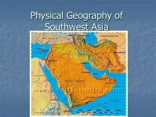
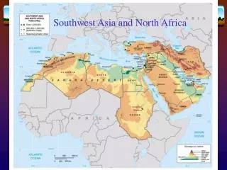
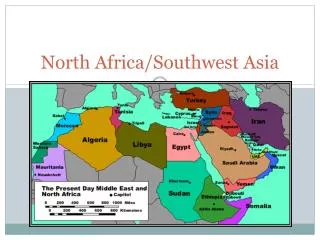
Physical Geography of North Africa, Southwest Asia, and Central Asia.

E N D
Physical Geographyof North Africa,Southwest Asia, andCentral Asia
Physical Features: The people of Turkey’s Göreme Valley dwell in cliff-side apartments carved by nature. These mountain homes have storerooms on lower levels and family living quarters that include kitchens. Telephone-like devices allow family members to communicate from different floors. Wind and rain, as well as volcanoes and earthquakes, have shaped the rock and valleys of this land. Read on to find out about the landforms of North Africa, Southwest Asia, and Central Asia. Section 1
Main Idea This region includes a variety of landforms that affect how and where people live. Geography and You When you hear about floods, do you picture terrible damage and loss of life? Read to learn why people in ancient Egypt welcomed, rather than feared, river floods. The Region’sLandforms
Main Idea This region includes a variety of landforms that affect how and where people live. Geography and You When you hear about floods, do you picture terrible damage and loss of life? Read to learn why people in ancient Egypt welcomed, rather than feared, river floods. Main Idea
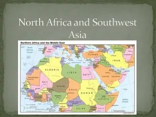
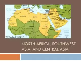
Look at the physical map in the Regional Atlas to see the oceans and seas that surround North Africa, Southwest Asia, and Central Asia. These bodies of water have helped people trade more easily with the rest of Africa, Asia, and Europe. Four waterways control access to these seas. In the west, the Strait of Gibraltar—separating Africa and Europe—links the Mediterranean Sea with the Atlantic Ocean. In the north, the Dardanelles (dahrd·uhn·EHLZ) Strait, the Sea of Marmara (MAHR·mah·rah), and the Bosporus (BAHS·puh·ruhs) Strait together link the Mediterranean and Black Seas and separate Europe from Asia. Seas and Waterways
On North Africa’s eastern edge, there is a human-made waterway called the Suez Canal. Ships use this canal to pass from the Mediterranean Sea to the Red Sea. North of the Arabian Peninsula, the Strait of Hormuz (HAWR·muhz) allows oil tankers to enter and leave the Persian Gulf. Seas and Waterways
All three areas within the region have somewhat similar landscapes. In North Africa, the Atlas and Ahaggar Mountains extend across much of the west. The rest of North Africa is covered by low plains and low-lying plateaus. Mountains, Plateaus, and Lowlands
Because of the region’s rugged and dry land, people have long settled in river valleys to take advantage of the rich soil. Early civilizations developed along Egypt’s Nile River and Southwest Asia’s Tigris and Euphrates Rivers Rivers
The ancient Egyptians relied on the Nile’s yearly flooding. The floods not only supplied water, but also carried silt—small particles of rich soil. The silt made the land fertile for growing crops. Rivers
Flooding of the Tigris and Euphrates Rivers, in a region called Mesopotamia, also led to a civilization based on farming. Mesopotamia was located on an alluvial (uh·LOO·vee·uhl) plain, an area of fertile soil left by river floods. Farmers built channels and ditches to bring water to their fields. Rivers
Oil and Gas The largest reserves of petroleum and natural gas can be found in the area of the Persian Gulf. Oil is common here because the land is made up of sedimentary rock. This rock is created when layers of material are hardened by the intense weight of more materials piled above. Over millions of years, heat and pressure below the Earth’s surface helped turn the remains of sea animals and plants into oil. The oil collected in the gaps between the rock. Natural Resources
In addition to oil and natural gas, the region has other important resources. Both coal and iron ore are found in the region. Morocco and Kazakhstan have rich deposits of phosphates, which are mineral salts used to make fertilizer. Other Resources
The region’s two inland seas, the Caspian (KAS·pee·uhn) and the Aral, have suffered greatly in recent decades. In the Caspian Sea, poaching, which is illegal fishing or hunting, has decreased the number of sturgeon, the fish whose eggs are used to make caviar. This drop has hurt the fishing industry in countries around the Caspian Sea. Environmental Concerns—The Seas
The Aral Sea, which is shared by Kazakhstan and Uzbekistan, has also been badly damaged. During the 1960s, irrigation projects, mainly for cotton production, drained water from the two main rivers that feed the sea. Inadequate amounts of rainfall could not restore the sea’s water level, and it began drying up. In addition, the sea’s water became saltier and unfit for drinking. This change also harmed the sea’s fish populations.
The misuse of water has also harmed the land throughout North Africa, Southwest Asia, and Central Asia. Because the climate is so dry in much of the region, irrigation water often evaporates. This can leave behind a deposit of salt that makes the land less fertile. In some cases, the damage is so great that the land can no longer be farmed. Other Environmental Issues
Dams built to control flooding have both benefited and harmed the environment. In 1968 Egypt’s government opened the Aswˉan High Dam on the upper Nile River. By controlling the river’s floodwaters, crops can be grown and harvested throughout the year. In addition, the dam provides electric power to Egypt’s growing cities and industries. Nile
also is a growing problem. A large number of cars in the region are older, and they release more polluting fumes. Refineries, the facilities that turn petroleum into gasoline and other products, also pollute the air. Air pollution
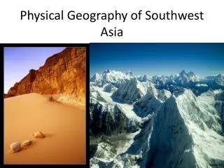
A Dry Region Main Idea Large areas of desert greatly affect life in the region. Geography and You What would it be like to live through a long period without rain? Read to find out how a generally dry climate affects vegetation and human activities. Section 2 ClimateRegions
Dry continental air masses warmed by the sun blow over much of North Africa, Southwest Asia, and Central Asia. As a result, much of the land is desert with a dry, hot climate. A Dry Region
The vast Sahara, the world’s largest desert, covers much of North Africa. Summer temperatures can reach scorching highs. The highest temperature ever recorded, 136°F (58°C), was measured at Al-‘Azˉızˉıyah (al·a·ZEE·zee·yuh), in Libya. Winter temperatures are cooler, averaging about 55°F (13°C). The Sahara
Only about 3 inches (8 cm) of rain fall each year in the Sahara. Rain usually falls in the winter months, but occasional violent thunderstorms in summer can cause flooding. Dry riverbeds called wadisfill with water when it rains. wadis
Most of the Sahara is dry land covered with rock or gravel. About 20 percent of the desert is covered by large sand dunes, which are called ergs. The Sahara also contains oaseswhere the land is fertile as a result of water from a spring or well. Villages, towns, and cities have grown around many Saharan oases.
The region has other desert areas besides the Sahara. The Arabian Peninsula is nearly covered by deserts. In the south lies the vast Rub’ al Khali, or Empty Quarter. About the size of Texas, this sandy area averages only about 4 inches (10 cm) of rainfall per year. Desert and Steppe Areas
rain shadow areas created by high peaks along with dry continental winds have formed large deserts—the Kara-Kum and the KyzylKum. Both deserts have hot summers but very cold winters. That is because these areas are in the middle latitudes. In Central Asia
Bordering the region’s deserts are dry, treeless, but grassy plains called steppes. Steppes are found in areas north of the Sahara, Turkey, and to the east in Central Asia. Steppe areas receive more rainfall— between 4 and 16 inches (10 and 41 cm) per year—than do deserts. Some people on the steppes live as nomads, moving across steppe areas to find food and water for their herds. Others practice dry farming, a method in which land is left unplanted every few years so that it can store moisture. steppes
Coastal areas in North Africa, the eastern Mediterranean, and Turkey have Mediterranean climates. These warm areas receive enough rain to support agriculture and therefore have more people than other parts of the region. Other Climate Areas
Main Idea The lack of water is a growing problem in this region. Geography and You How much water do you use each day? How might your life be different if the amount of water you used daily was limited? Read to learn how people try to make the best use of limited water resources. The Need for Water
Rainfall is sparse over much of the region. Also, high temperatures cause surface water to evaporate rapidly. As a result, the growing population does not have adequate water to meet its needs. A large amount of water is used to irrigate dry farmland. Some countries, such as Libya, now draw water from aquifers, or underground rock layers through which water flows. Figure 1 on the previous page shows aquifers in a part of the region. Rainfall is sparse
In addition, countries often compete for scarce water resources, increasing the chance of conflict. For example, dams that Turkey is building on the Tigris and Euphrates Rivers redirect water that in the past would have flowed to Syria and Iraq. Some governments, such as those of Jordan and Syria, are dealing with water shortages by rationing. Rationing means that a resource is made available to people in only limited amounts.
Another approach to managing water use is desalinization. This process treats seawater to remove salts and minerals and make it drinkable. Oil-rich countries have built desalinization plants, making Southwest Asia the world’s leader in creating usable water from seawater. Desalinization is costly, however, so poor countries are not able to use this process and will continue to face water shortages. desalinization
History and Cultures of North Africa, Southwest Asia, and Central Asia Place: The region of North Africa, Southwest Asia, and Central Asia is the birthplace of three world religions— Judaism, Christianity, and Islam. Since their beginnings thousands of years ago, these religions have spread throughout the world. They also have had a great impact on the history of the region. How does religion affect the lives of people today? Chapter 17
BIG IDEA The characteristics and movement of people affect physical and human systems. The people of ancient Egypt and Mesopotamia built civilizations in fertile river valleys. They made many advances that spread to neighboring areas. Judaism, Christianity, and Islam have greatly influenced culture and politics over the centuries. In recent times, political unrest and conflict have troubled the region. Section 1: History and Religion
The words and pictures that are carved into the stone describe a great famine on the Egyptian island of Sehel. Stone markers, called stelae (STEE∙lee), were often used in ancient Egypt to honor the dead or to remember special events. Egypt is one of the world’s earliest civilizations and is known for its achievements in language, arts, and trade. To learn more about Egypt’s history, read Section 1. History and Religion
Main Idea The early civilizations of Mesopotamia and Egypt had a great impact on later civilizations. Geography and You What do you view as the greatest human achievement? Sending people to the moon, perhaps, or inventing the computer? Read to learn about the accomplishments of two early civilizations. Early Civilizations
Two of the world’s oldest civilizations arose in Southwest Asia and North Africa about 5,000 years ago. Egypt, in North Africa, developed along the banks of the Nile River. The other civilization, Mesopotamia (____suh_puh_TAY_mee_uh) in Southwest Asia, arose on a flat plain between the Tigris and Euphrates Rivers. world’s oldest civilizations
Mesopotamia— located in present-day Iraq—lay in the Fertile Crescent, a strip of land that curves from the Mediterranean Sea to the Persian Gulf. Around 4000 _._., people began settling along the Tigris and Euphrates Rivers. There they farmed the fertile soil left behind by yearly floods. To control flooding and carry water to their fields, they built walls, waterways, and ditches. This method of watering crops is called irrigation. Irrigation allowed the people to grow a larger, more stable supply of food. More food, in turn, supported a larger population. By 3000 _._., cities had developed in southern Mesopotamia in a region known as Sumer (SOO_muhr). world’s oldest civilizations
Each Sumerian city and the land around it formed its own government and came to be called a city-state. At the center of each city was a large, step like temple dedicated to the city’s chief god. Mesopotamia’s religion was based on polytheism, or the worship of many gods and goddesses. At first, each city-state was a theocracy, or a government controlled by religious leaders. Later, military leaders took power. Sumerian city
The Sumerians developed a number of remarkable inventions. They created one of the first calendars and were the first people known to use the wheel and the plow. They also developed cuneiform, which was an early form of writing. Cuneiform consists of wedge-shaped markings made with sharp reeds on clay tablets. writing
Religion was at the center of Egyptian society. Egyptians worshiped many gods and goddesses. Like Mesopotamia, Egypt was a theocracy. Egyptian rulers were called pharaohs, and the Egyptians believed that they were gods as well as rulers. The pharaohs owned the land and ordered thousands of people to build temples and tombs. The largest tombs, the pyramids, belonged to the pharaohs. Later, pharaohs were buried in tombs built into cliffs.
The Egyptians also developed a system of writing called hieroglyphics, which used pictures for words or sounds. The Egyptians carved and painted these symbols on the walls of the magnificent stone temples they built to honor their gods. hieroglyphics
Trade was very important to the people of Mesopotamia. They traded with people from the eastern Mediterranean region to India. Through trade and conquest, the achievements and ideas of Mesopotamia spread to other lands. Some still shape life today. For example, the 60-second minute, 60-minute hour, 24-hour day, and 12-month year that we use today were developed by the Sumerians. Connecting Ancient Lands
One of the greatest trading empires of the ancient world developed in the land of Phoenicia. Around 1000 b.c., the Phoenicians—who lived in what is now Lebanon—engaged in trade all across the Mediterranean Sea. They traveled and traded as far west as present-day Spain. Phoenicians
Main Idea Three major world religions began in Southwest Asia. Geography and You Is there a synagogue, a church, or a mosque in your community? These places of worship represent three major religions: Judaism, Christianity, and Islam. Read to find out about these three religions that began in Southwest Asia. Three World Religions
Judaism, Christianity, and Islam have become major world faiths. All three religions are examples of monotheism, or the belief in one God. one God.
The oldest of the three religions is Judaism. It was first practiced by a small group of people in Southwest Asia called the Israelites. The followers of Judaism today are known as Jews. We know about the early history of the Jewish people and their religion from their holy book—the Tanakh, or the Hebrew Bible. Judaism
According to Jewish belief, the Jews are descended from Abraham, a herder who lived in Mesopotamia about 1800 b.c. The Tanakh states that God made a covenant, or agreement, with Abraham. If Abraham moved to the land of Canaan, he and his descendants would be blessed. Abraham’s descendants, later called the Israelites, believed they would continue to be blessed as long as they followed God’s laws. Abraham
Jews believe that God revealed the most important of these laws to a prophet, or messenger of God, named Moses. According to the Hebrew Bible, Moses led the Israelites from Egypt. The Israelites had moved to Egypt to escape a long drought and were forced into slavery there. On their way from Egypt, at the top of Mount Sinai (SY∙ny) in the desert, Moses received Moses