Download
1 / 19
190 likes | 204 Views
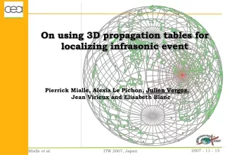
Improve earthquake locations with minimal computational effort using precomputed station-specific travel time tables based on a 3D earth model. Organization into interfaces and small-scale tetrahedra allows for efficient calculation. Examples of travel time tables, sensitivity tests, and preliminary location errors are shown.

E N D
Goal: improve earthquake locations while minimizing computation effort through precomputation
Three-D earth model elliptical earth model ½ degree resolution, tetrahedral splines based on available structural information Crust 2.0 Pn tomography Surface wave tomography
Overall organization into interfaces Small-scale organization into tetrahedra Linear interpolation within tetrahedra implying rays that are circular arcs
First Cut at building a 3-d MODEL Simplified, 2-layer-crust version of Crust 2.0 on top of AK135 mantle with sub-Moho velocities adjusted to match Crust 2.0 Pn velocities
Strategy Compute differential traveltimes between 3D model and reference vertically-stratified model one traveltime calculation for each station gives traveltime correction for earthquake anywhere in the US to that station
Sensitivity Test Test grid of earthquake hypocenters Current US station configuration Traveltimes for 3D model Location using AK135 Assess location error
Location Errors: = 0.5 degree Note: this preliminary calculation used data from a limited number of stations