Download
1 / 16
160 likes | 162 Views
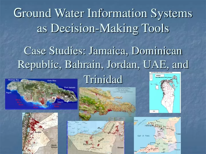
This case study explores the use of Ground Water Information Systems (GWIS) as decision-making tools in water-stressed and water-scarce countries. It examines the integration of data, analysis, interpretation, and reporting in GWIS to aid in sustainable development and water resource management. The case studies include Jamaica, Dominican Republic, Bahrain, Jordan, UAE, and Trinidad.

E N D
Ground Water Information Systems as Decision-Making Tools Case Studies: Jamaica, Dominican Republic, Bahrain, Jordan, UAE, and Trinidad
Faculty of Pure & Applied Sciences by Dr. Jasminko KaranjacProfessor & Chair in Water Resources Managementat the University of the West Indies, JamaicaPrepared for the Conference on Water Observation and Information System for Decision Support, Ohrid, Macedonia, 25-29 May 2004 Organized by
Ground water data collection and information management are essential prerequisites for any ground-water-resources based decision-making.
A modern Ground Water Information System (GWIS) integrates all data, descriptive or quantitative, it links to Geographic Information Systems (GIS), makes the analysis and interpretation of data a routine procedure, and presents and reports data and information in a way that helps in decision-making.
Numerous maps and dedicated diagrams, graphs, and cross sections are made a part of the GWIS. • A GWIS stores information on lithology of aquifers, water quality over an extended period of time and at different depths, evolution of water levels, abstractions for various uses, etc.
Case Study: Jamaica It is said that Christopher Columbus upon landing in Jamaica shouted, “Water, water everywhere”. Today, with population of about 2.7 millions and available water estimated at 4,083 million cubic meters per year (MCM/yr), Jamaica with 1,512 m3/yr/capita falls into “water-stressed” category. Ground water accounts for about 86% of all available water.
GWIS of JAMAICA currently contains information from over 1000 wells and springs. Numerous maps and dedicated diagrams, graphs, and cross sections are made a part of the GWIS.
There are about 2000 wells in the GWIS of the Dominican Republic
Case Study: BahrainThe GWIS of Bahrain, established in 1994/95 under a UNDP project, consists of about 2000 wells. With a comprehensive GWIS, one of routine retrievals, which may impact decision-making, is to point at the sites with an inferior water quality. Currently there is moratorium on new wells drilling.
Case Study: Jordan The GWIS of Jordan contains about 4600 wells (red dots in the map). It was created in 1996 as a part of the National Water Master Plan. Jordan is a water scarce country, with water availability estimated at 180 m3/yr/capita.
Case Study: Abu Dhabi Emirate All United Arab Emirates are scarce with water.Seawater desalination is the major source of supply. Yet, in one part of the Abu Dhabi Emirate, in Al Ain area, aquifers contain fresh ground water. The GWIS established for this Emirate contains about 1300 wells, most of them drilled in the Al Ain area. • Two things make the GWIS of Abu Dhabi specific: • oil wells included in GWIS • geophysical logging data stored in GWIS.
The map shows wells currently in the GWIS of Trinidad. There are about 1000 wells. As a decision-making tool, the GWIS of Trinidad can be used to check the relationship between abstraction and water levels in Port of Spain, point at areas with promising lithologies, look into deeper Case Study: Trinidad layers (limestone) so far spared from development, check ground water suitability for irrigation, etc.
Conclusions A Ground Water Information System is both a database that contains and provides access to inventory information about drilled sites, wells, test holes, springs, lakes, reservoirs, ponds, excavations, and water-use facilities, and an information system with field and laboratory data turned into information. To be a real decision-making tool, a GWIS needs to be well integrated, and comprehensive, with field data and information checked, validated, processed and brought up-to-date.
The database, along with various thematic maps, cross sections, time- and depth-diagrams, makes an object-oriented information system which lends itself to analysis, assessment, interpretation, presentation and reporting. In water-scarce countries, such as Jordan, Bahrain and Abu Dhabi Emirate, the sustainable development (agriculture, tourism, services, and domestic water supply) is dependent on a full comprehension of the ground water system that may provide the only natural source of water.
In island countries in which most of the population lives near the coast and most of economic development depends on availability of good quality water supply, a GWIS if based on data obtained from monitoring networks easily points at vulnerable areas in which ground water contamination may result from seawater intrusion due to excessive abstraction, industrial pollution, or inadequate sewage system.
The need for data and information, especially in water-stressed and water-scarce countries emphasizes the role of monitoring networks for data collection. In island countries the networks should include (a) seawater intrusion control, (b) ground water level monitoring, and (c) ground water quality observations.