Download
1 / 46
480 likes | 812 Views
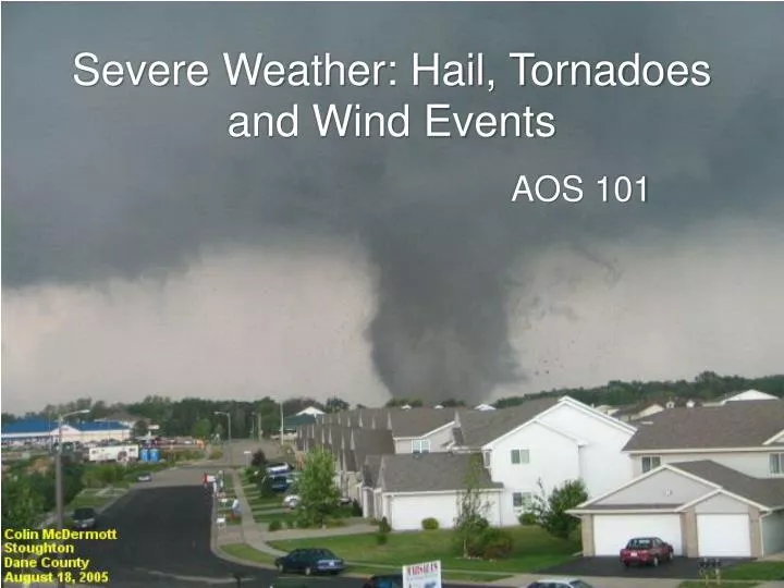
Severe Weather: Hail, Tornadoes and Wind Events. AOS 101. Thunderstorms. Ingredients for Thunderstorms. In spring and summer, the following conditions can help to drive the formation of severe convective storms. 1. Instability 2. Moisture 3. Lifting Mechanism

E N D
Ingredients for Thunderstorms In spring and summer, the following conditions can help to drive the formation of severe convective storms. 1. Instability 2. Moisture 3. Lifting Mechanism (upward vertical motion)4. Wind Shear Other factors that affect storm growth and development of severe weather 1. “Capping” Inversion
1. Instability When a parcel is lifted from the surface and finds itself in an environment where the parcel is warmer than its environment, the atmosphere is said to be unstableThis is a situation in which a positive bouyancy force helps to accelerate the parcel upward
2. Moisture • Since a conditionally unstable atmosphere is only unstable with respect to saturated air parcel, moisture is needed to create severe weather. High moisture > High Td > Low LCL > Low LFC > Less lifting needed for parcels to reach level of free convection
Warm, moist air from the Gulf of Mexico is being advected by cyclone over the plains
Stability Index: Lifted Index (LI) • It starts with an air parcel from the surface, lifting and cooling it dry adiabatically to saturation, and then lifting and cooling further moist adiabatically to 500 mb. • To compute Lifted Index, Tenv – Tparcel • So if the observed temperature is colder than the lifted air parcel • Parcel is unstable, continue to rise • LI is negative
Region of negative Lifted Index indicates air is conditionally unstable for an air parcel lifted from the surface to 500 hPa
Capping Inversion • For severe weather to occur, the air near surface has to be very moist. • To achieve that, we have to prevent the mixing of moist air below with dry air above. • Capping inversion can develop when hot dry air at about 700mb overlies warm, moist air near surface. • It can prevent this mixing, and allows the air near surface to become moist, and air above remains dry.
With no capping inversion Gulf of Mexico Central Plains 1. Surface winds advect moisture from Gulf of Mexico to Central Plains 2. Convective cells allow mixing of moist air below with dry air above. 3. Central Plains remain relatively dry.
With capping inversion Central Plains Gulf of Mexico 1. Surface winds advect moisture from Gulf of Mexico to Central Plains 2. Capping inversion suppresses convective cells. Keeping near surface air moist, and air above it dry. Hot, dry air aloft acting like a lid on a boiling pot, allowing air below to continue to warm by the sun. 3. Until the surface air got enough energy to break the cap and rush upward violently to rapidly form severe weather.
On the typical summer day, the atmosphere will be conditionally unstable.Stable for unsaturated parcelsUnstable for saturated parcelsSurface (unsaturated) parcels will not be able to rise on their own. A push is needed for SEVERE WEATHER to occur to break through the capping inversion. Some mechanismsmust raise the parcel until it reaches saturation (LCL) and then past a level at which it is warmer than its surroundings (LFC). 3. Lifting Mechanism
Different types of Lifting Mechanisms 1. Sufficient Surface Heating (Convection) 2. Convergence of Low Level Winds 3. Topography (such as mountains, etc.) 4. Outflow boundaries 5. Fronts
4. Wind Shear • Wind shear is a term to describe how wind speed and direction with height • There are 2 types: • Directional shear (direction of winds change with height) • Speed shear (same direction of winds, but speed changes with height). 4 km 2 km 6 km sfc DIRECTIONAL 6 km 4 km 2 km sfc SPEED
Purpose of Wind Shear • Vertical shear allows for a t’storm to continue to take up moisture. This makes the t’storm circulation able to continue thriving by displacing the downdraft from the updraft • Without shear, the downdrafts cut off the moisture source of the thunderstorm (updraft) • Thunderstorms can intensify and last longer
Thunderstorm is formed and maintained by continuous supply of moisture by updraft. No Wind Shear Rain is produced, falling down as downdraft, disrupting the upward vertical motion that feeds the storm. Storm dissipates.
With Wind Shear Thunderstorm is formed and maintained by continuous supply of moisture by updraft. Rain is produced, falling down as downdraft away from the updraft. Allowing the storm to continue to grow.
Severe Thunderstorm Criteria NWS definition: A thunderstorm is SEVERE if it has one or more of the following. -Wind gusts in excess of 50 knots (58mph)-Hail > 1 in diameter-Tornado
Wind -Must be 58mph wind gust or stronger Most intense winds are generated when downdrafts hit the surface and spread out (aka downbursts or microbursts). - Have been reported to exceed 120 mph (EF 0 tornado)
Hail -Must be 1 in (nickel size) diameter or larger (pea and marble size hail are not considered severe)
Tornado Oklahoma City Tornado:May 3, 1999 Wind: 318mph! • Definition: violently rotating column of air in contact with the ground and extending from a cumulonimbus cloud
Tornado Formation • http://esminfo.prenhall.com/science/geoanimations/animations/Tornadoes.html • http://www.youtube.com/watch?v=sitd8nef4QI
Supercells -Most dangerous of all storms -Downbursts -Mesocyclone- thunderstorm with deep, rotating updraft -Can produce large hail (+2”) -Weak to violent tornadoes (EF0-EF5 on Enhanced Fujita Scale) - Need directional wind shear
EF0-EF5 Enhanced Fujita Scale Tornado Wind and Damage Scale
Time lapses .. Youtube is actually good for observing weather.. http://www.youtube.com/watch?v=yCg6U87W4YQ
Stability Indices • Stability indices usually can be calculated using temperatures (and dew point temperatures) from a few mandatory levels from a radiosonde sounding. • Purpose: • to obtain a number to provide some measure of the overall stability of the atmosphere. • to evaluate the potential for severe weather / predict thunderstorms to occur
However… • Since they are only calculated using a few levels of the sounding, many details on the soundings are not accounted for. • Sounding is a snapshot of the atmosphere. Stability indices calculated from sounding would not tell us how the atmosphere is going to evolve later on.
Lifted Index (LI) • Compares the parcel with the environment at 500mb. • Takes into account both near surface moisture content and static stability LI = (Tenv-Tparcel)500
Showalter Index (SI) • Compares a parcel starting at 850mb with the environment at 500mb. • Tells us instability aloft other than from near surface. SI = (Tenv-Tparcel)500
Vertical Totals VT = T850 - T500 • Account for static stability in between 850 to 500 hPa. • A value of 26 or greater is usually indicative of thunderstorm potential.
Cross Totals CT =T d850 - T500 • Account for 850hPa low level moisture.
Total Totals (TT) TT = VT + CT = T850 + T d850 - 2 T500 • Not as useful when all low level moisture lies below 850 hPa
K Index K = T850 - T 500 + Td850 – (T700 - Td700) • Takes into account of the vertical distribution of moisture and temperature. • 700 hPa moisture, which is important for air mass thunderstorms development.
SWEAT (Severe Weather thrEAT) Index SWI = 12D + 20(T - 49) + 2f8 + f5 + 125(S + 0.2) where: D=850mb dew point temperature (oC) (if D<0 then set D = 0) T = total totals (if T < 49 then set entire term = 0) f8=speed of 850mb winds (knots) f5= speed of 500mb winds (knots) S = sin (500mb-850mb wind direction) And set the term 125(S+0.2) = 0 when any of the following are not true • 850mb wind direction is between 130-250 • 500mb wind direction is between 210-310 • 500mb wind direction minus 850mb wind direction is positive • 850mb and 500mb wind speeds > 15knots
SWEAT (severe weather threat) Index SWI = 12D + 20(T - 49) + 2f8 + f5 + 125(S + 0.2)
Convective Available Potential Energy (CAPE) • Amount of buoyant energy available as parcel accelerate upward. • It contains information about the overall stability of the atmosphere. • Does not only based on a few levels, but the whole profile in the calculation.
Convective Inhibition (CIN) • The amount of energy required to lift the parcel from surface to LFC. • > 200 Jkg-1 (strongly inhibit convective potential)
Freezing Level • Lowest level on a sounding in which 0 deg Celsius is found. • Follow 0 deg C isotherm up, until it reaches the and crosses the temperature profile.