Download
1 / 60
620 likes | 1.12k Views
BENUA DAN SAMUDERA Continent and Ocean. Akbar Bagas Pramantya (2) Maulisa Dewi Mahenda (11) Missy Savira (12) Nadila Arisa Andriani (14) Yosua Feri Wijaya (19) Zahra Hasina Nizami (20). BENUA ASIA Asia Continent.

E N D
BENUA DAN SAMUDERAContinent and Ocean Akbar BagasPramantya (2) MaulisaDewiMahenda (11) Missy Savira (12) NadilaArisaAndriani (14) YosuaFeriWijaya (19) Zahra HasinaNizami (20)
BENUA ASIA Asia Continent
Astronomically , Asia continent is positioned at 79⁰NL – 11⁰SL and 25⁰EM – 170⁰WM Secara astronomis , Benua Asia terletak antara 79⁰LU – 11⁰LS dan 25⁰BT – 170⁰BB • The boundaries of Asia Continent are as follows : • North : Arctic Ocean • East : Pacific Ocean • South : Indian Ocean 4. West : Ural mountain, Caucasus Mountain , The caspian sea , Dardanela strait, Black sea Batas batas wilayah Benua Asia adalah : 1. Utara : Samudera Arktik 2. Timur : Samudera Pasifik 3. Selatan : Samudera Hindia 4. Barat : Pegunungan Ural , pegunungan Kaukasus , Laut Kaspia , Selat Dardanela , Laut Hitam
Topography BentangAlam • High land : (dataran tinggi ) • Tibet • Anatolia • Dekkan • Lowland: (dataran rendah ) • Siberia • Hindusta • Mountain : (pegunungan) • Himalaya Mt • Hindu Mt • Kunlun Mt
Topography BentangAlam • North Lowland Region (Dataran Rendah Utara ) includes most of Siberia and Turan lowland in Russia. Mencakup sebagian besar Siberia dan dataran rendah Turan di Russia • Young Mountain Fold (Lipatan Pegunungan Muda) Young mountain that pass through Asia are Circum Mediterranean and Circum Pasific. Circum Mediterranean streches from the Mediterranean sea to Turkey and goes on Caucasus Mountain. Dua rangkaian pegunungan muda yang melewati Benua Asia adalah Pegunungan Muda Sirkum Mediteran dan Sirkum Pasifik . Memanjang dari Laut Tengah menuju Turki yang berlanjut ke Pegunungan Kaukasus
ClimateIklim • Tropical climate (iklim tropis) rainy and dry season (musim hujan dan kemarau) tropical climate is marked by : iklim tropis ditandai oleh 1. high rainfall curah hujan tinggi 2. High temperature suhu yang tinggi 3. High humidity kelembapan yang tinggi the region includes : most of South east Asia and West coast of India wilayahnya meliputi sebagian besar Asia Tenggara dan pantai barat India
ClimateIklim • Subtropical climate (iklim subtropis) is marked by : ditandai oleh 1. High temperature in summer suhu tinggi di musim panas 2. Low temperature in winter because rainfall is higher in this season suhu rendah di musim dingin the region includes : Minor Asia and East Asia wilayahnya yang termasuk : Asia Kecil dan Timur • Polar-Continental Climate( Iklim Kontinental-Kutub) long winter season and short period of summer the region includes : part of North Asia Musim dingin yang panjang dan musim panas yang singkat . Wilayahnya meliputi sebagian Asia Utara
ClimateIklim • Continental climate (Iklim Kontinental) is marked by dominant land influence the region includes : Siberia ditandai dengan adanya pengarug daratan yang sangatdominan. Wilayahnyameliputisiberia. • Desert climate (iklim Gurun) is marked by extremed temperature (rainfall is very low) the region includes : Gobi desert , Takla makan , Mongolia , Tibet , Arabian Peninsula Ditandai oleh variasi suhu yang sangat ekstrem (curah hujan yang sangat rendah) . Wilayah yang termasuk adalah Gurun Gobi , Taklan Makan , Mongolia , Tibet , Jazirah Arab.
PopulationPopulasi Asia is a continent with a large number of population If it seen from ethnicity , can be distinguished into two main races , they are Caucasoid and Mongoloid The religions which are professed by Asians are Islam , Christianity , Buddhism , animism , atheist Asia adalah sebuah benua yang penduduknya paling besar . Jika dilihat dari suku bangsanya penduduk Asia dapat dibedakan menjadi 2 yaitu Suku Kaukasoid (kulit putih)dan Mongoloid (kulit hitam) Agama yang dianut penduduk Asia adalah Islam , Kristen , Hindu , Buddha , animisme atau Atheis
BenuaAmerikamerupakanbenua yang terakhirditemukan. Secaraastronomis, BenuaAmerikaterletakpada 85 LU – 55 LS dan 10 BB – 170 BB. Secarageografis, batasbataswilayahbenuaAmerikaadalahsebagaiberikut • America continentis the last found continent. Astronomically, America is located between 85 NL – 55 NL and 10 EM – 170 EM. Geographically, the boundaries of America continent are as follow a. Utara : LautArtik, Laut Beaufort, Teluk Hudson North : Arctic Sea, Beaufort Sea, Hudson Bay b. Timur : SamudraAtlantik, SelatMagelhaens East : Atlantic Ocean, Magelhaens Strait c. Barat : SamudraPasifik, Laut Bering West : Pacific Ocean, Bering Sea d. Selatan : SamudraPasifik South : Pacific Ocean
BeberapanegaradibenuaAmerika : • Some countries in America continent : • Amerikautara / North America • AmerikaSerikat, Meksiko, danKanada • United States, Mexico, and Canada • Amerikatengah / Central America Bahama, Kuba, Jamaika, Haiti, Dominika, Belize, Guatemala, El Savaador, Honduras, Nikaragua, Costarica, Panama, dannegara-negarakecildikepulauanAntila. Bahamas, Cuba, Jamaica, Haiti, Dominica, Belize, Guatemala, El Savador, Honduras, Nicaragua, Costarica, Panama, and all small countries in Antila island • Amerikaselatan / South America Kolombia, Venezuela, Guyana, Suriname, Equador, Peru, Brazil, Cile, Bolivia, Paraguay, Uruguay, dan Argentina Columbia, Venezuela, Guyana, Suriname, Ecuador, Peru, Brazil, Chile, Bolivia, Paraguay, Uruguay, and Argentina
Amerikautara / North America KawasanAmerikautaramembentangdarikutubutarasampaiperbatasanMeksiko. KawasaninidilaluiolehjalurpegununganmudayaituPegunungan Rocky. KawasaninijugadilaluiolehjalurpegunungantuayaituPegunungan Appalachia (disebelahtimur). BersamadenganPegunungan Cordillera (disebelahbarat), Pegunungan Appalachia dikenaldengansebutan “PerisaiKanada”. North America region stretches from North Pole until the mexican boundaries. This region is passed by a young mountain belt, that is the rocky mountains. And this region also passed by old mountain belt that is Appalachian Mountains (in the east). With Cordillera Mountains, Appalachian Mountains is known as “Canadian Shield”. IklimdikawasanAmerikautaraadalahiklimsubtropissampaiiklim tundra. Climate of North America region is subtropical until tundra climate. Di kawasaniniterdapatAmerikaSerikat yang menyebabkankawasaninimerupakankawasan yang paling pesatperkembanganekonominya. In this region there is USA that cause this region is the fastest region in America continent of economic growth.
Amerikatengah / Central America CirikhaspermukaanbumiAmerika Tengah adalah Plato Tengah Meksikoyaitusebuahbongkahan yang menjulangdenganketinggian 2500 m dpl. Di kawasanini, terdapatbeberapadanausepertiDananuManguadanDanauNikanagua The characteristic of Central America earth surface is Mexico Central Plateau which is a chunk of 2500 m high aboce the sea level. In this region, there are some lakes such as Mengua and Nikanagua lakes. KawasanAmerika Tengah iniumumnyaberiklimtropis. Sebagianbesarkawasaninimendapatpengaruhlaut, sehinggawilayahAmerika Tengah mendapatpengaruharushangatdarisamudera, baikdariarusbalikekuatorialPasifikmaupunarusbalikekuatorialAtlantik Generally Central America Region has tropical climate. Most of this region gets sea influence, so Central America gets influence of warm current from the ocean, which comes from Pacific equatorial reverse stream and Atlantic equatorial reserve stream. LandasanperekonomianAmerika Tengah adalahsektorpertanian. The economic foundation in Central America is farming.
Amerikaselatan / South America BentangalamAmerika Selatan terdiridarijalurpegununganyaituPegunungan Andes. Di sebelahtimurterdapatdatarantinggi Guyana dan Brazil. DiantaraPegunungan Andes dandatarantinggitimurterdapatdataranrendah Amazon (utara) dandataranrendah Parana dan Paraguay (selatan). The topography of South America consist of mountain belt that is Andes Mountains. In the east there are Guyana and Brazilian Highlands. Between the Andes Mountains and East highland, there are Amazon Lowland (north) and Parana and Paraguay Lowland (south). KawasanAmerika Selatan beriklimtropisdengancurahhujancukuptinggi. Generally South America Region has tropical climate with the average of rainfall is high enough. KawasanAmerikaselatankayaakansumber mineral dAnhasilpertanian. Venezuela merupakan areal tambangminyakbumiterbesardikawasanini. South America region is rich in mineral resources and farming product. Venezuela is the largest petroleum mining site in this region.
Secaraastronomis, BenuaAfrikaterletakpada 40LU-38LS dan 17BB-52BT. Secarageografisbatas-bataswilayahAfrikaadalahsebagaiberikut:Astronomically, Africa Continent is located between 40NL-38SL and 17WM-52EM. Geographically, the boundaries of Africa as follow:Utara = Lauttengahdanselat GibraltarNorth = Mediterannean Sea and Gibraltar StraitTimur = Lautmerah, Teluk Aden, danSamuderaHindiaEast = Red Sea, Aden Sea, and Indian OceanSelatan = SamuderaHindiaSouth = Indian OceanBarat = SamuderaAtlantikWest = Atlantic Ocean
BentangalamTopography Wilayah pegununganAfrikaterdiridariPegunungan Atlas yang terletakdisebelahbaratdanPegunungan Naga terletakdisebelahselatansampaitenggaraAfrika.The mountain ranges of Africa consist of Atlas Mountains which is located in the northwest and Naga mountains which is located in the south until south east of Africa. Wilayah Afrikasebagianbesarnyaditutupidatarantinggidanplato yang dibagimenjaditigabagian. Plato Fauta Djallon disebelahbarat, Plato Jos, platoAdamous, Plato Banga, Plato Katto, Plato Tibsi, dan Plato Kamenadibagiantengahdan Plato KaraodibagianselatanAfrika.Most of Africa region is covered by highlands and plateaus which are divided into three parts. Fauto Djallon Plateau in the west, Jos Plateau, Adamous Plateau, Banga Plateau, Katto Plateau, Tibsi Plateau, and Kamena Plateau in the centre and Karao Plateau in the south of Africa.
Basin yang terluasterdapatdipedalamanyaitu, Basin Chad, Basin DanayTigani, dan Basin Rudolf. KawasanlembahpatahanAfrikaterletakdibagianTimur yang membujurutarakeselatan. Terdapatjugadanau-danaubesar. AdapungunungtertinggidikawasanAfrikaadalahGunung Kilimanjaro (5.889 m dpl) danGunung Kenya (5.194 m dpl).The largest basin is located in the rural area they are, Basin of Chad, Tigani Lake and Rudolf. the fault valley region of Africa is located in the east of Africa continent which stretches from north to south. In this region there are some big lakes. The highest mountain in Africa is Mount Kilimanjaro (5,889 m above sea level) and Mount Kenya (5,194 m above sea level).b. IklimClimateKeadaaniklimAfrikabervariasi. IklimgurunmeliputiGurun Sahara, Gurun Chad, danGurun Kalahari. Wilayah pantai Tenggara AfrikadansekitarlautMediteraniamempunyaiiklimmediteran. Adapunsebelahutaradanselatanekuatorberiklimsabanatropis.The climate condition in Africa Continent varies relatively. Desert climate includes Sahara, Chad, and Kalahari deserts. South east coast region of Africa and around The Mediterranean have Mediterranean climate. The north and south parts of equator have savannah tropical.
c. KeadaanpendudukPopulation conditionJumlahpendudukmencapai 861 jutajiwa. Karenasebagianbesarpenduduknyaberkulithitam, makaBenuaAfrikaseringdisebut “BenuaHitam”. Wilayah afrika yang paling banyakpenduduknyaterdapatdiAfrika Utara. PendudukAfrikadapatdibedakanmenjadi 3 ras:Population of Africa reached 861 million people. Because most of the population have black skin, Africa continent is often called “Black Continent”. Africa regions with the highest density of population can be found in North Africa. Population of Africa can be divided into three types of race: 1) Rasnegroid, merupakanras paling banyakdiAfrika. Terdiriatas Negro Sudan dan Negro Bantu.Negroid race, is the greatest race in Africa. They are Sudan Negro and Bantu Negro. 2) RasKaukosoid, merupakanras yang banyakmenempatiwilayahAfrika Utara.Caucasoid-Hamit, is the race living in most parts of North Africa. 3) Etnikkhusus, merupaansukubangsa yang masih primitive. Yaitu, sukubangsaPygmee, Bushmen, danHottentot.Special ethnic groups are the primitive ethnic group. They are, Pygmee, Bushmen, and Hottentot.
d. KegiatanEkonomiEconomic ActivityKegiatanekonomiAfrikamasihbergantungpadasektorpertanian. Jenistanaman yang dibudidayakanadalahtanamanpangandantanamanperdagangan. Kegiatanpeternakanjugamemegangperananpenting. Sektor industry Afrikahanyamenyerapsedikittenagakerja. Sektorpertambanganmerupakanmatapencaharian yang cukuppentingdiAfrika.The economic activities of Africa still depend on farming sector with various types of farming. The plants which are grown are food crops and commercial crops. Animal husbandry activities also have important role. The industrial sector in Africa only absorbs a little workforce. The mining sector is an important livelihood in Africa.
BenuaEropaterletakdisebelah Barat Benua Asia. BahkandapatdikatakanbahwaBenuaEropaadalahsemenanjungbagian Barat Benua Asia yang dibatasiolehrangkaianPegunungan Ural.Europe continent is located in the west continent of Asia. It can even be said that Europe continent is the western part the western part of Asia peninsula bounded by a series of the Ural Mountains.Secarageografis, Eropasebenarnyabukanlahsuatubenua, namundarikemajuanbudayadanperanannya yang menonjol, makaEropadapatberdirisendirisebagaisuatukawasanbenua.Geographically, Europe is actually not a continent , but of cultural progress and the prominent role, then Europe can stand alone as a region of the continent.
Secaraastronomis, BenuaEropaterletakdiantara ± 10° BB - 59° BT dan ± 71° LU - 35° LU, sehinggaseluruhwilayahnyaberadadibelahanbumi Utara. Luaswilayahnyamencapai ± 10.355.000 km² (± 6,5 % luaswilayahdaratandunia) denganbatas-bataswilayahberikutini.1) Sebelah Utara berbatasandenganSamudraArktik.2) SebelahTimurberbatasandenganBenua Asia.3) Sebelah Selatan berbatasandenganLaut Tengah, LautHitam, dannegaraTurki.4) Sebelah Barat berbatasandenganSamudraAtlantik.Astronomically, the European continent lies between ± 10 ° BB - 59 ° east and ± 71 ° N - 35 ° N, so that the whole territory was in the Northern hemisphere. Its area reaches ±10.355 million km ² (± 6.5% of the world's land area) with the boundaries of these regions.1) North side bordering the Arctic Ocean.2) the East with the continent of Asia.3) Southern bordered by Mediterranean Sea, Black Sea, and the Turkish state.4) West bordered by Atlantic Ocean.
KondisiFisikEropamerupakansatu-satunyabenua yang tidakmemilikiwilayahgurun. Jikadilihatdaribentukwilayahnya, makabenuainidicirikandenganbentukanalamsemenanjung yang tersebarditigawilayahutama, yaituSemenanjungSkandinaviadibagian Utara, Semenanjung Siberia dibagian Barat, danSemenanjung Italia dibagian Selatan. Kondisifisik yang lain akandiuraikanberikutini.Physical Condition Europe is the only continent without a desert region. When viewed from the form of its territory, the continent is characterized by the formation of natural peninsula spread across three main areas, namely the Scandinavian Peninsula in Northern Peninsula in western Siberia, and the Italian Peninsula in the South. Other physical conditions will be described below.1 ) IklimEropamerupakanbenua yang terletakdilintangtinggi, sehinggaterletakdikawasanberiklimsedanghinggadingin, bahkanadawilayahnyadibagian Utara yang telahmasuklingkaranKutub Utara. KeadaantersebutmenyebabkanEropamempunyaikondisiiklimberikutini.1) Climate Europe is a continent which is located at high latitudes, that is located in moderate to coldclimates, there is even a territory in the north who had entered the Arctic circle. These circumstances led to Europe having the following cilmatic conditions.
a) Di bagianpantai Barat dipengaruhiiklimlautdariSamudraAtlantik, arushangat yang mengalirdariSamudraAtlantikmenyebabkankawasanpantaididaerahtersebuttidakmembeku.b) Di bagiantengahterjadiperalihaniklimmaritim yang basahkeiklimkontinen yang kering.c) Di bagian Selatan dipengaruhiiklimLautMediteraniadanangindarikawasangurun yang panas, sehinggakondisicuacanyamenjadilebihhangat.d) Di bagian Utara dipengaruhiiklimkutub yang dingin.a) On the west coast marine climate influenced from the Atlantic Ocean, warm currents flowing from the Atlantic coast caused in the area does not freeze.b) In the middle of a shift to the wet maritime climate is dry continental climate. c) In the southern part of the Mediterranean Sea and climate influenced the winds from hot desert regions, so the weather becomes warmer conditions.d) In the northern part influenced by the cold polar climate.Wilayah pegunungandiEropaterdapatdibagiansemenanjung-semenanjungnya yang dibedakanataspegunungantuadikawasan Utara danpegununganlipatanmudadikawasan Selatan.Mountainous areas in Europe are located on the peninsula, which is distinguished above peninsula old mountains in northern and mountainous peninsula old mountains in northern and mountainous region folds in the South region.
PegunungandiEropa, yaitugugusanpegunungantuadiNorwegia yang membentangdari Utara ke Selatan denganpuncaktertinggiGunungGaldhopiggen (2.470 m), PegununganAlpendikawasanMediteraniadenganpuncaktertinggidi Mount Blanc (4.808 m), PegununganKaukasusdisebelah Selatan denganpuncaktertinggidiGunung Elbrus (5.633 m), danPegunungan Ural disebelahTimur yang merupakanbatasalamantaraBenuaEropadenganBenua Asia. Gunung-gunungdiwilayahBenuaEropapadaumumnyamasihaktif, namuntidakterlalutinggi, danpuncaknyadiselimutisalju.Mountains in Europe, namely the cluster of old in the Norwegian mountains which stretches from north to south with the highest peak of Mount Galdhopiggen (2470 m), the Alps to the Mediterranean region with the highest peak on Mount Blanc (4808 m), the Caucasus Mountains to the south with the highest peak Mount Elbrus (5633 m), and the Ural Mountains in the east which is the natural border between continental Europe, the continent of Asia. The mountains in the territory of Continental Europe in general is still active, but not too high and its peak covered in snow.
3 ) Sungai dandanaudiEropaSungai-sungaidiEropapadaumumnyadijadikansebagaibatasalamantarnegara, seperti Sungai Rhein (1.320 km) yang menjadibatasalamnegara Swiss, Liechtenstein, Austria, Prancis, danJerman. Selainitu, terdapatjuga Sungai Elbe danDapudediJerman, Sungai Loire dan Sungai Ruhr diPrancis, serta Sungai Uberdan Sungai WeichediPolandia.Sungai-sungaitersebutpadaumumnyaberhuludiPegununganAlpendanbermuaradiLautBaltikdanLaut Utara. AdapunpersebarandanaudikawasanEropabanyakdijumpaidikawasan Utara, sepertiDanau Vattern, DanauVanem, DanauHyalmaren, DanauStasyondiSwedia, DanauOrevesii, DanauPaulavesi, DanauOuluyami, Danau Inari diFinlandia, Danau Onega, danDanau Ladoga diRusia.3) Rivers and lakes in EuropeRivers in Europe in general, serve as natural barriers between countries, such as the Rhine (1320 km) is the natural border of Switzerland, Liechtenstein, Austria, France, and Germany. In addition, there is also the River Elbe and Dapude in Germany, the River Loireand the River Ruhr in France, as well as Uber River and River Weiche in Poland.The rivers are generally tipped in the Alps and empties into the Baltic Sea and North Sea.The distribution of lakes in Europe are often found in the Northern region, like Lake Vattern, Lake Vanem, Hyalmaren Lake, Lake Stasyon in Sweden, Orevesii Lake, Lake Paulavesi, Ouluyami Lake, Lake Inari in Findland, Lake Onega, and Lake Ladoga in Russia.
4 ) Flora dan fauna diEropa Flora dan fauna yang berkembangdiBenuaEropapadadasarnyasamadengan flora dan fauna yang berkembangdikawasanberiklimsedangdandingin. Jenis flora yang tumbuhdikawasanini, adalahhutankonifera (tumbuhanberdaunjarum) danhutan yang meluruhkandaunnyadimusimgugur.Jenis flora yang lain adalahpohon maple, ek, iris, lily, danzaitun. Adapun fauna khas yang hidupdiEropaadalahrusa, beruangkutub, serigala, ikan tuna, danikan haring.4) Flora and Fauna in Europe Flora and fauna that developed in Continental Europe is essentially the same as the floraand fauna that thrive in temperate and cold regions. Flora species that grow in this region,is a coniferous forest (needle-leaved plantes) and forest shed their leaves in autumn. Other types of flora which are maple, oak, iris, lily, and olevies. The typical fauna that live in Europe is a deer, polar bears, wolves, tuna, and herring.
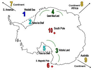
Benua yang berpusatasimetrisdikutubselataninimerupakantempat paling dingindantandusdipermukaanbumi. Temperaturbenuaini 12 derajatcelsiuslebihrendahdaripadabentuaArtik, karenabenuainimemilikimassatanah yang luasdanpadat, denganketinggian rata-rata lebihdari 1880 m diataspermukaanlaut. Antartikadikelilingiolehsamudrapasifik, samudrahindia, dansamudraatlantik, luasantartikakirakira 13,209,800 km. This continent which asymmetrically centers in the south pole is the coldest and the most barren place in the earth’s surface. This temperature of this continent is 12 degrees Celsius lower than Arctic, because this continent region has wider and more solid soil mass, with average height of more than1880 m above the sea. Antarctic is surrounded by the pacific ocean, Indian ocean, and Atlantic ocean. The area of Antarctic is about 13,209,000 km.
Lapisanes yang menutupibenuaantartikatidaktersebarmeratatetapimengisilembahdangunung. Padamusimdingin, samudraantartika yang mengelilingibunaantartikmembukusampailebihdari 3m (ketebalannya). Bongkahan-bongkahanesterbesarterjadipadabulanAgustussampai September. Dan wilayahpedalamanAntartikabergunung-gunung. The ice layer which covers Antarctic continent is not spread evenly but fills the valley and mountains. In winter period, the Antarctic ocean which surrounds Antarctic continent freezes until more than 3m thick. The biggest ice chunks are found in August until September. And the hinterland of Antarctic is mountainous.
BENUA AUSTRALIA Australia Continent
Batas-batas Boundaries • Utara : LautArafuru , LautTimor North : Arafuru Sea, East Sea • Barat : SamuderaHindia West : Indian Ocean • Timur : SamuderaPasifik East : Pacific Ocean • Selatan : SamuderaHindia South : Indian Ocean • Titiktertinggi : Gunung Kosciusko diNew South Wales Highest point : Koscuisko Mt in New South Wales • Titikterendah : DanauEyre Lowest paint : Eyre lake • •B. Climate • •The climate of Australia varies greatly from region to region, with a tropical climate in the north, an arid or semiarid climate in much of the interior, and a temperate climate in the south. • •The temperate regions of southern Australia have four seasons, with cool winters and warm summers. January and February (the warmest months). June and July (the coldest months). Seasonal variations are much less pronounced in northern Australia, which has a tropical climate. This region essentially has only two seasons: a hot and a warm • \
B. Climate Iklim Australia sangatbervariasidaridaerahkedaerah, denganiklimtropisdiutara, iklimkeringatau semi keringdisebagianbesar,daniklimsedangdiselatan. The climate of Australia varies greatly from region to region, with a tropical climate in the north, an arid or semiarid climate in much of the interior, and a temperate climate in the south. Daerah-daerahberiklimselatan Australia memilikiempatmusim, denganmusimdingin yang sejukdanmusimpanas yang hangat. JanuaridanFebruari (bulanterpanas) JunidanJuli (bulan-bulanterdingin). Variasimusimanbegituterasadibagianutara Australia, yangmemilikiiklimtropis. Daerah inipadadasarnyahanyamemilikiduamusim: panasdanhangat The temperate regions of southern Australia have four seasons, with cool winters and warm summers. January and February (the warmest months). June and July (the coldest months). Seasonal variations are much less pronounced in northern Australia, which has a tropical climate. This region essentially has only two seasons: a hot and a warm
Binatangkhas Australia • Animals Koala (Koala) Platipus(Platypus) Kanguru(Kangoroo) E. Populasi E. Population • Dilihatdarietnik, Australia memilikisukuAborigin • If it seen from ethnicity , in Australia has Aboriginrace • Agama yang paling banyakdianutadalahKatolik • The most of religion is Catholic
LuasSamudraPasifikmencapai ± 165.385.450 km² dengankedalaman rata-rata 4.250 m. Jikadilihatdi globe, luassamudrainimeliputihampirseparuhpermukaanbumi. SamudraPasifikterletakdiantaratigabenua, yaitu Asia, Amerika, dan Australia. Area of the Pacific Ocean reaches ± 165.385 450 km ² with an average depth of 4250 m. When viewed in the globe, vast ocean covers nearly half the earth's surface. Pacific Ocean lies between there continents namely, Asia, America, and Australia. Wilayahnyaterbentangdaripantai Barat AmerikahinggapantaiTimurCinadan Australia denganberbagaikarakterstikberikutini: a. SamudraPasifikmerupakansamudraterluasdidunia b. Di SamudraPasifikterdapattitikterendahdimukabumi, yaituPalung Mariana (kedalaman 11.022 m) terdapatdi Filipina. c. SamudraPasifikmemilikibanyakpalung, yaituPalung Tonga (10.882 m), Palung Kuril (10.542 m), Palung Filipina (10.497 m), PalungKermatec (10.047 m), Palung Tzu Bonin (9.810 m), Palung New Hebrides (9.165 m), Palung South Solomon (9.140 m), PalungJepang (8.412 m), Palung Peru-Cile (8.066 m), PalungAkution (7.822 m), danPalungAmerika Tengah (6.662 m). d. Di SamudraPasifikbanyakterdapatgunungapiaktif, sehinggaseringterjadigempa.
e. SamudraPasifikmerupakantempatpertemuanantaragarisbujur Barat danbujurTimur (180°) sebagaibataspenanggalaninternasional. f. Di SamudraPasifikbanyakterdapatnegarakepulauan (kawasan Oceania). g. Di SamudraPasifikbanyakterjadigejalaalam El Nino dan La Nina, terutamadiperairan yang dilintasigariskatulistiwa. h. Di SamudraPasifikterdapatpertemuanaruspanasKurosyiwodanarusdinginOyasyiwodiLaut Bearing (Pasifik Utara) yang menimbulkanarushangatdanmerupakankawasantangkapanikan yang sangatbaik. Its territory stretches from the western coast of America to the coast of China and Australia with a variety of the following characteristics: a. Pacific Ocean is the largest ocean in the world.b. In the Pacific Ocean there is the lowest point on earth, the Mariana Trench (11,022 m depth) is located in the Philippines.c. Pacific Ocean has many troughsd. In the Pacific Ocean there are many active volcanoes, earthquake occur so frequently.
e. Ocean Pacific is a meeting place between the lines of longitude West and Eastlongitude (180 °) as the international dateline.f. In the Pacific Ocean there are many island nations (Oceania region).g. In the Pacific Ocean there are many natural phenomena of El Nino and La Nina,especially in the waters crossed by the equator.h. In the Pacific Ocean there is a meeting of the heat flow OyasyiwoKurosyiwo and coldcurrents in the Bearing Sea (North Pacific) that give rise to an area of warm currents andfish catches are very good.
SamudraAtlantikadalahsamudraterbesarkeduadidunia, meliputisekitar 1/5 permukaanBumi. Atlantic Ocean is the world's second largest ocean, covering approximately 1 / 5 the surface of the Earth. LuasSamudraAtlantikmencapai ± 82.217.000 km² dengankedalaman rata-rata 3.350 m. Memanjangdaribelahanbumiutarakebelahanbumiselatan, terbagiolehduagarisgkhatulistiwamenjadiAtlantik Utara danAtlantik Selatan. DibatasiolehAmerika Utara danAmerika Selatan dibagianbarat, sertabenuaEropadanAfrikadibagiantimur. Sehinggamenjadijalurlalulintaspenghubungantaradunia lama denganduniabaru. Karakteristik: The area of the Atlantic Ocean reaches ± 82.217 million km ² with an average depth of 3350 m. This ocean, is extending from the northern hemisphere to the southern hemisphere, and divided in two by the equator as the North Atlantic and South Atlantic. Bordered by North America and South America in the western part, also Europe and Africa continent in the eastern ocean. This situation makes Atlantic ocean become the traffic lanes of the old world with new world. Charateristic:
SamudraAtlantikterletakdidaerahbujur Barat. b. SamudraAtlantikmemilikikawasan yang diyakinisebagaipusatmedan magnet bumi, yaitudikawasanSegitiga Bermuda diPerairanKaribia (Amerika Tengah). c. Di SamudraAtlantikterdapatderetanpunggunglautterpanjangdidunia, memanjangdari Utara (SamudraArktik) ke Selatan sepanjangSamudraAtlantikdankeTimurmenujuSamudraHindia. d. Di SamudraAtlantikterdapatpertemuanarusdingindariPerairan Greenland danaruspanasdariTelukMeksikodiPerairan Labrador. e. Di SamudraAtlantikterdapatbeberapapalunglaut a. Atlantic Ocean is located in West longitude.b. Atlantic Ocean has an area believed to be the center of the Earth's magnetic field, namely Bermuda Triangle that located in the waters of the Caribbean (Middle America).c. In the Atlantic there is the world's longest sea, extending from the North (Arctic Ocean) to the south along the Atlantic Ocean and to the East toward the Indian Ocean.d. In the Atlantic there is a meeting of the cold currents from the waters of Greenland and the heat flow from the Gulf of Mexico in the waters of Labrador.e. In the Atlantic there are several sea trenches