Download
1 / 1
10 likes | 171 Views
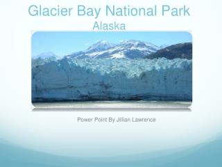
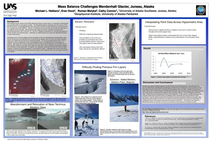
Mass Balance Challenges Mendenhall Glacier, Juneau, Alaska Michael L. Hekkers 1 , Eran Hood 1 , Roman Motyka 2 , Cathy Connor 1 , 1 University of Alaska Southeast, Juneau, Alaska ; 2 Geophysical Institute, University of Alaska Fairbanks. Results:. Background

E N D
Mass Balance Challenges Mendenhall Glacier, Juneau, Alaska Michael L. Hekkers1, Eran Hood1, Roman Motyka2, Cathy Connor1,1University of Alaska Southeast, Juneau, Alaska; 2Geophysical Institute, University of Alaska Fairbanks Results: Background With 400,000 annual visitors to the USFS Mendenhall Glacier Visitor Center, it’s important to disseminate accurate information on the glacier’s health. The Mendenhall Glacier retreated over 5 km from its 1750 AD LIA maximum, creating Mendenhall Lake, and recent lacustrine calving retreat has increased from 60 ma-1 through most of the 2000s to ~150 ma-1 the last two years as the terminus thinned and retreated to an icefall proximal to the lake. Annual glacial mass balance has been quantified stratigraphically discontinuously since 1997 (-0.93 ma-1 to -1.44 ma-1). Despite its importance for conveying the effects of climate change to the general public, challenges on understanding how quickly the Mendenhall Glacier is losing mass remain. Challenges exist in both the ablation and accumulation zones and interpolating point data glacier-wide. Recent retreat has forced abandonment of near-terminus ablation sites and other sites were relocated away from icefalls that have become increasingly steeper. The ELA fluctuated between 830-1,370 m (1998-2011) which changed two of nine annual balance sites on Mendenhall from accumulation to ablation. With nearly 30 m annual snowfall and little summer time dust deposition on the snow, the firn layer has been difficult to ascertain at the upper four sites (900-1,500 m) despite using magnet markers and spreading of landscaping bark. The glacier has undergone significant thinning since the last USGS mapping, impairing accurate interpolation of mass balance results. Challenges also remain reconciling stratigraphic annual balance with laser altimetry surveys, which measure only one of two upper branches of the glacier. Solution: Relocation Interpolating Point Data Across Hypsometric Area Results • Potential Issues: • Glacial area is rapidly shrinking in ablation zone and to a lesser extent throughout the entire glacial area. • When mass balance data is interpolated with non-current older clipped DEMs, underestimates of ablation and overestimates of accumulation likely occur. • Potential Issues: • Shading • Difficulty comparing historical data • Inaccessibility to the center line prohibits ground-based radio echo sounding depths used for calving flux calculations used in mass balance • Also decreased velocity which will make calving flux calculations difficult June 2009 June 2012 Figure 7. Surface mass balance (excludes lake calving) 1, 2, 3. Figure 3. Relocation of abandoned 2010 ablation sites (green) and relocated sites (orange). Introduction Solutions: Added Markers, Ablation Poles, Magnets Discussion and Conclusions As with most rapidly changing glaciers, mostly thinning and retreating glaciers, field methods must accommodate these changing glacial landscapes whether that is changing the camera angles on fixed time-lapse cameras (Figure 2) or moving point mass balance sites up-valley. Despite the proximity to trails, lake access, and the heliports, the Mendenhall Glacier has numerous physical and weather barriers that make access to historical mass balance sites sometimes difficult. Of the challenges mentioned above, determining accumulation poses the most challenges. Current uses of a visible bark layer and magnets (which have yet to be found), and ablation poles, along with accurate projections of their movement, must be refined to determine the definitive ice layer and obtain reliable accumulation data. Repeated yearly geodetic surveys such as lidar and aerial photogrammetry would aid interpolation of stratigraphic point mass balance data and provide good comparisons. The health (mass balance) Mendenhall Glacier is important not only for the scientific community but to the public as well. Figure 5. One solution is to deposit a 35 m2 visible bark layer at the end of the ablation season and a large magnet. Thirty meters of annual snow fall, and ~100 m annual velocity make finding these clues difficult. Abandonment and Relocation of Near-Terminus Ablation Sites Difficulty Finding Previous Firn Layers For more Mendenhall Glacier Facts go to the links web page of Environmental Science Department at the University of Alaska Southeast http://www.uas.alaska.edu/envs/links.html Figure 4. Crevasses and snow pits have several ice layers, some caused by fall or winter rain-on-snow events, but no obvious dirty layers. References 1Larsen, C.F., Motyka, R.J., Arendt, A.A., Echelmeyer, K.A., and P.E. Geissler. 2007. Glacier changes in southeast Alaska and northwest British Columbia and contribution to sea level rise. Journal of Geophysical Research 112:F01007, doi:10.1029/2006JF000586. 2Motyka, R.J., O’Neel, S., Connor, C.L., and K.A. Echelmeyer. 2002. Twentieth century thinning of Mendenhall Glacier, Alaska, and its relationship to climate, lake calving, and glacier run-off. Global and Planetary Change35: 93-112. 3E.S. Boyce, R.J. Motyka and M. Truffer. 2007. Flotation and Retreat of a Lake-Calving Terminus, Mendenhall Glacier, Southeast Alaska. Journal of Glaciology, 53(181), 211-224. Figure 1. The Mendenhall Glacier has retreated 5 km since the LIA maximum in 1760 (left) and has recently (right) accelerated from an average ~55 ma-1 retreat in the 2000’s to 135-165 ma-1 the last couple years. Figure 6. Another solution in 2011 was a 5 m high accumulation pole. A record 2011-2012 snowfall and a cold stormy spring will likely leave this buried through summer’s end. Figure 2. Red dots indicate former ablation sites that have calved into Mendenhall Lake (lower) and are inaccessible (upper) because of increased crevassing. The dashed line shows approximate 2012 position shown on the right. The box on the right shows area of the 2009 image and a much steeper and retreated (~300 m) glacier face than 2009. Acknowledgments: Support is provided in part by the National Science Foundation EAR-0943599. Special thanks to numerous students who helped collect the data over the years. Ron Marvin and Laurie Craig at the USFS Mendenhall Glacier Visitor Center provided lake access, support ,and feedback. Northstar Trekking and Temsco Helicopters donated helicopter time. June 26, 2012 International Glaciology Conference, Fairbanks, Alaska