Download
1 / 11
110 likes | 230 Views
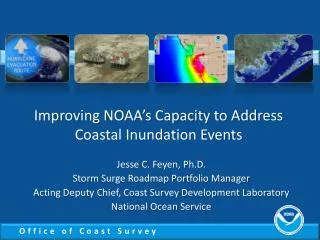
NOAA Strategies for Coastal Inundation Presentation to the Climate Working Group of the Science Advisory Board July 31, 2012 Margaret A. Davidson, Chair Paul M. Scholz, Project Lead. Key Accomplishments. The Value of NOAA Inundation Products and Services, 2012

E N D
NOAA Strategies for Coastal Inundation Presentation to the Climate Working Group of the Science Advisory Board July 31, 2012 Margaret A. Davidson, Chair Paul M. Scholz, Project Lead
Key Accomplishments The Value of NOAA Inundation Products and Services, 2012 Sea-level Rise Needs Assessment, 2011 Current Practices in Coastal Inundation Mapping, white paper, 2011 Draft Vision and Strategic Vision Framework, 2010 Storm Surge Roadmap, 2010 NOAA’s Role in the Monitoring and Prediction of Long-Term Sea-Level Rise, white paper, 2009 A Vision for NOAA’s Coast, Estuary, River Information Services (CERIS), 2009
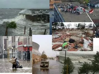
Why Coastal Inundation? • Increased risk and vulnerability on the coasts • >50% of U.S. population live within 50 miles of the coast • 60 percent of GDP generated in coastal counties • Aging infrastructure, expensive to upgrade/replace • Rise in LOSSES of at least $1B insured damages per event • Local & regional efforts essential • Coastal inundation differs according to local geomorphology and hydrology • Policies and mandates are most often issued by towns, cities, counties rather than by state or federal agencies
Coastal Inundation and Climate • Coasts and Climate Resilience Societal Challenge • “Where’s the water going to be and when?” • Topic refined by NOAA to address cross-line office execution issues related to coasts and community resilience • Storm surge • Tsunami • River flooding/fresh water inflow • Sea-level rise • NOAA coastal inundation activities also support climate but have primary missions
Addressing Coastal Inundation Draft Summary Schedule, 2012 • Terms of reference approved (July) • Scope and boundary conditions for requirements plan determined (July) • Requirements plan drafted (Sept) • Draft plan circulated to advisors and stakeholders (Oct) • Plan reviewed and evaluated in light of FY13 appropriations (TBD) • Progress Monitored, evaluated (on-going) Executive Working Group • Margaret Davidson, OCRM (Chair) • Leon Cammen, Sea Grant • Gary Carter, OHD • Richard Edwing, CO-OPS • Wayne Higgins, CPC • Tom Karl, NCDC • Rick Rosen, CPO Project Lead • Paul Scholz , NOS - CSC Advisors (representative examples) • IOOS, NMFS S&T, NCDC, GFDL, NIDIS, FEMA-Mitigation, ACOE-IWS, DOI-USGS, DOE, EPA, ASFPM, AMS-Director of Policy Program
Boundary and Scope of Coastal Inundation Challenge • Total water level issues across NOAA • Impact-oriented • Focused on coastal inundation impacts, regardless of origin of water • Recognizing phenomena have different modeling, information, data needs • NOAA and the Integrators • Working across climate issues to meet user demands • Strategies for engaging external partners and customers • Reduce internal firewalls
Integrating Solutions: Cascading Hazards How high is the water going to go? When is going to get here? Should I stay or should I go? What else am I facing?
Issues and Strategies: Input from CWG • Community approach toward modeling • to include local and global, as well as academia, private sector, governmental, and nongovernmental interests • Strategies for engaging communities in risk assessment and risk evaluation
Key Cross Phenomenon Needs • Data needs • All four programs need bathymetric and topographic data and water level observations • Modeling and Coupling • Models in the four programs need to be coupled and/or combined, where the science allows, to the Earth System Modeling Framework • Display software • NOAA inundation products should have a common look and feel • All four programs need capable and user friendly mapping and associated software • Use standard GIS formats and methods • Outreach/Customer Support • Dissemination methods and services need to be similar, utilizing social science methods