Download
1 / 29
290 likes | 435 Views
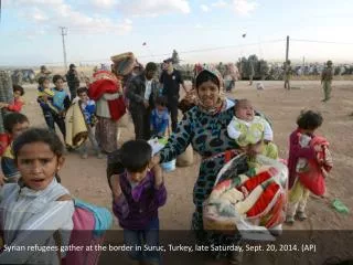
Attempting Escape: A Network Based Analysis of North Korean Refugees. Capt Krysta Anthony LT Kevin Kerno. Historical Background. History of North Korea Human r ights issues What is the rest of the world doing?. North Korean Escapees. 1,500 North Koreans escaped in 2012

E N D
Attempting Escape:A Network Based Analysis of North Korean Refugees Capt Krysta Anthony LT Kevin Kerno
Historical Background • History of North Korea • Human rights issues • What is the rest of the world doing?
North Korean Escapees • 1,500 North Koreans escaped in 2012 • So what’s the big deal? • Extremely arduous/perilous journey • Difficult to travel within in North Korea • Geography • Government agents • Sex Traffickers • Kidnappers • China illegally deports North Korean refugees • Classifies North Korean refugees as “economic immigrants”
How does one escape? • The “New Underground Railroad” • Who is helping • What makes it up • How it works • Where do the refugees go? • China first • Then exit into Mongolia and Southeast Asia • Reaching South Korea
Problem Statement What are the best routes for North Korean escapees to take when fleeing from North Korea?
Research Questions • What is the shortest route an escapee can take to fully escape? • What is the safest route an escapee can take? • What general route provides the highest likelihood of escape? • Where are the most likely points of interdiction both inside of North Korea and in China? • How can resources be allocated to assist North Korean refugees escape?
Challenges in Creating Network • Limited published information and data • Most information is word of mouth and anecdotal • Pieced multiple accounts and sources together • Utilized Google Earth • Utilized geographical data, topographical maps, and intuition
Assumptions/Project Limitations • Three starting points in North Korea that represent southern, central, and northern regions • Considering a single escapee • All edge probabilities within North Korea are the same • Similar for border crossings and within China • Only considered straight line distances • The only escape paths out of NK are into China • If in China, an escapee must escape to Mongolia or Southeast Asia to be considered safe • Average speed refugees moving is 10 km/hr for 14 hours per day
Overview of Network • Nodes: Cities, towns, villages, border crossing points, and airports in North Korea, China, Mongolia, and Southeast Asia • Edges: Straight line routes between the above nodes • Super sink to Escape from Bangkok, Ulaanbaatar, Vientiane, Manila and Seoul • Edge Costs: Initially the straight line distance in kilometers • Then assigned probabilities of evading authorities to each edge
Shortest Path Escape Route Start Point: Haeju Total Distance: 2244 km Start Point: Kyo-Hwa-So 4 Total Distance: 2139 km Start Point: Pungsan Total Distance: 2279 km
Analysis: Basic Model • Shortest path routes in terms of distance from three starting points within North Korea • Results • All paths lead to Chinggis-Khaan International Airport in Mongolia • Refugee must travel over 2200 km • Conclusion • Average total travel time with no delays would be 17 days • Tumen River crossing is longest
More Realistic Edge Costs • Scaled the overall edge lengths • To determine edge probabilities we took the following into account: • Where the edge is located (i.e. North Korea, China, between North Korea and China, etc.) • What locations the edge is linking • The overall edge length in km • Rate of capture on an edge (percent): • 20%/hour: North Korea Edges • 30%/hour: North Korea into China border crossing • 10%/hour: China edges
More Realistic Edge Costs • To generate edge probabilities we applied the following transformation
More Realistic Edge Costs • We then take the –ln of the probability of evading to use as our new edge costs: • Now, the goal is to maximize the overall probability of escape
Probabilistic Escape Route Start Point: Haeju POE: 11.4% Start Point: Kyo-Hwa-So 4 POE: 16.0% Start Point: Pungsan POE: 5.9%
Analysis: More Realistic Model • Highest probabilities of escaping from the three starting points • No interdiction • Results • Highest probability of escape: 16.0% • Lowest probability of escape: 5.9% • Conclusions • All escape routes through Capital International Airport in Beijing • Tumen River crossing most dangerous
Interdiction • Forms of attack • North Korean agents and government informants • Chinese agents and government informants • Kidnappers • Sex traffickers • Human trafficking organizations • Modeled attacks on an edge by placing a “checkpoint” on that edge
Implementing Attacks • “Checkpoint” encompasses all above forms of attack • No “checkpoints” outside of China and North Korea • Checkpoints are not 100% effective • Each “checkpoint” causes a 6-hour delay • Looked at a varying number of checkpoints to determine effect on safest path
Probabilistic Escape Routes with 5 Checkpoints Start Point: Haeju POE: 1.40% Start Point: Kyo-Hwa-So 4 POE: 2.07% Start Point: Pungsan POE: 1.10%
Analysis: More Realistic Model with Interdiction • Highest probabilities of escaping from the three starting points with attacks • Results • Highest probability of escape: 2.04% • Lowest probability of escape: 1.10% • Non-nested solutions • Conclusions • “Checkpoints” do not alter paths, only drastically decrease probability of escape • Tumen River crossing most dangerous
Network Design • Adding resources to certain routes • Increasing probabilities of successful border crossing • Increasing the number of border crossings • Increasing the number of guides • Paying off government agents • With more resources, more escapees could escape through Beijing airport • Enhances their chances of escape • Avoids hundreds of miles of ground travel
Conclusions and Insights • Shortest path escape path greatly different than probability-based escape path • Tumen River Route • Longest of shortest path in distance • Most dangerous probabilistically • Addition of resources triples probability of escape • Keys to increasing the probability of escape • Get escapees to the Beijing airport • Add additional resources in China
Additional Research Opportunities • More detailed/accurate network • Roads, railways, bus routes, etc. • Changing probabilities • Lower escape probabilities out of concentration camps • Vary probabilities in China • Use maximum flow to solve the problem • Further implementation of network design aspects