Download
1 / 81
810 likes | 1.19k Views
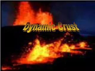
The Dynamic Crust. Topic 12 Topic 12 in Review Book. I. Evidence of Crustal Motion. Original horizontality A concept that assumes that sedimentary rocks (and some igneous rocks) form in horizontal layers parallel to Earth’s surface. These horizontal rock layers are called strata

E N D
The Dynamic Crust Topic 12 Topic 12 in Review Book
I. Evidence of Crustal Motion Original horizontality A concept that assumes that sedimentary rocks (and some igneous rocks) form in horizontal layers parallel to Earth’s surface
These horizontal rock layers are called strata Rock layers that are not horizontal are inferred to be deformed by crustal motion
1. Folded rock layers are bent or curved by pressing forces 2. Faulted rock layers are offset along a zone of weakness called a fault
3. Tilted rock strata are slanted or tipped away from horizontality 4. Displaced rock and fossils found hundreds of meters above sea level indicate that the land has been uplifted (raised up)
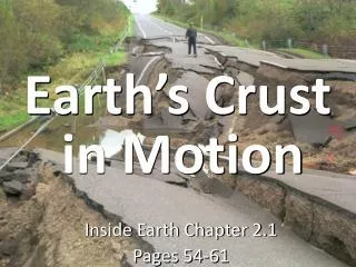
II. Consequences ofCrustal Motion 1. Mountain building 2. Earthquakes
An earthquake is a natural, rapid shaking of the lithosphere caused by the release of energy stored in rocks
Some earthquakes are caused by faulting, • some are associated with lithospheric motion and • some are associated with movements of magma
The potential energy stored in rocks is given off in seismic waves which travel outward from the point of motion in all directions
The focus of an earthquake is the starting point from which the seismic waves are emitted • The epicenter of an earthquake is the location on the earth’s surface directly above the focus
epicenter focus lithosphere
Analyzing EarthquakeData • There are three types of seismic waves: • P waves (primary waves) • S waves (secondary waves) • Surface waves
Properties of Seismic Waves • P waves are faster than any other seismic wave when traveling through the same material • Therefore, P waves will arrive at a seismic station first
In general, as the density of the material increases, the velocity of the seismic waves increases • As waves travel through areas of differing densities, they are refracted (bent)
As pressure increases, the velocity of seismic waves increases • P-waves will travel through solids, liquids and gases • S-waves will only travel through solids
Based upon this knowledge, seismic data has led to our understanding of the interior of the earth. • Based on the change in direction of the p and s waves, we believe that the outer core of the earth is liquid
Because seismic waves reflect off dense rock within the earth, they can be used to locate valuable rock and mineral resources
Locating the Epicenterof an Earthquake • Epicenters are located by using the velocity differences (lag time) between P and S waves.
Information from 3 stations is needed • The epicenter is where the circles drawn for all 3 stations intersect
A B C
The farther an observer is from the epicenter, the longer it takes the seismic waves to travel there • The longer they travel, the farther apart they get… • The greater the lag time
Analyzing Epicenter Information • PA and SA: read seismogram • Lag time: subtract SA – PA • Distance: measure lag time and slide and fit (use ESRT) • PT : go up and over from distance • OT : subtract PA - PT
An earthquake intensity (Mercalli) scale can be used to measure the effects on humans and/or their surroundings. • As distance from the epicenter increases, the amount of damage decreases
An earthquake magnitude (Richter) scale measures the strength of an earthquake… • The amount of energy released by the crustal motion
Risk Prevention • Proper planning can greatly reduce damage, death and injury from earthquakes
An individual should remember to drop, cover and hold… • Drop down under a strong object, cover your eyes. Hold onto the strong object. • DO NOT run out of the building
Community planning includes: • Inspecting the soil and bedrock to ensure building on solid ground • Retrofitting older buildings to make them safer…such as bolting buildings to their foundations and cross-bracing walls
Seismic sea waves or Tsunamis are large ocean waves formed due to a disruption on the ocean floor such as an earthquake, volcanic eruption or rapid landslide
b. Movement of Magma • When magma reaches the surface of the earth, it becomes lava • A volcano is a mountain made of extrusive igneous rock
A volcanic eruption is the release of gases, lava and/or lava rock onto the earth’s surface or into the atmosphere
People can be injured and killed by flowing lava, falling rock and gases of extreme temperature
Volcanic ash mixes with water to create massive mudslides and flooding • Gases can cause immediate death and/or long term lung damage • Volcanic ash in the atmosphere cools the earth by blocking insolation
Monitoring methods • Satellites measure infrared energy • Tilt meters measure increases in slope caused by magma inflating the volcano
Elevation benchmarks, latitude and longitude measurements and topographic maps indicate increases in elevation and width associated with eruptions
Measurements allow enough warning to develop emergency action plans including rescue and evacuation routes
The regions surrounding the Pacific Ocean contains many features associated with crustal activity and is referred to as the Ring of Fire
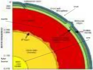
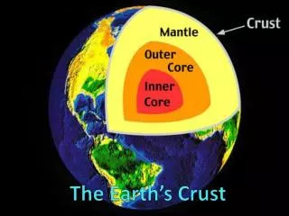
c. Earth’s Interior • Scientists infer most of the properties of the earth’s interior by studying seismic waves
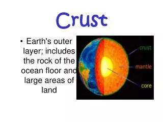
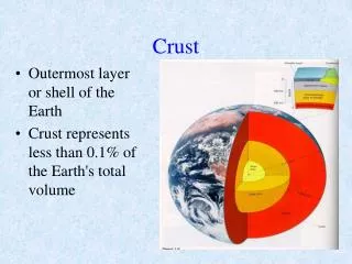
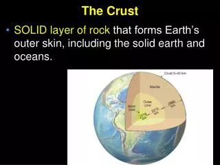
The crust is the outermost part of the earth which includes the soil and weathered and eroded rock • The mantle is the mostly solid region. It makes up ~80% of the earth’s volume
The interface between these two regions is called the Moho which is short for the Mohorovicic discontinuity
The lithosphere is the combined area of crust and rigid mantle. This is divided into sections called plates
Another portion of the upper mantle is the asthenosphere which is believed to be made of a plastic-like material that is partly magma Much of the magma and lava is thought to originate here
The earth’s core is divided into two parts. • Because s-waves cannot pass through the outer core, it cannot be a solid nor a gas; therefore it is believed to be a liquid