Download
1 / 30
300 likes | 559 Views
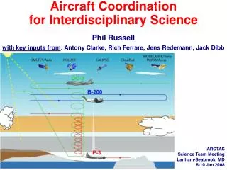
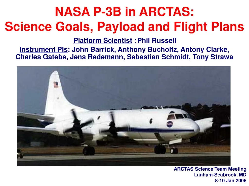
NASA P-3B in ARCTAS: Science Goals, Payload and Flight Plans Platform Scientist : Phil Russell Instrument PIs : John Barrick, Anthony Bucholtz, Antony Clarke, Charles Gatebe, Jens Redemann, Sebastian Schmidt, Tony Strawa. ARCTAS Science Team Meeting Lanham-Seabrook, MD 8-10 Jan 2008.

E N D
NASA P-3B in ARCTAS:Science Goals, Payload and Flight PlansPlatform Scientist :Phil Russell Instrument PIs: John Barrick, Anthony Bucholtz, Antony Clarke, Charles Gatebe, Jens Redemann, Sebastian Schmidt, Tony Strawa ARCTAS Science Team Meeting Lanham-Seabrook, MD 8-10 Jan 2008
P-3B in ARCTAS • Overall Goal: Contribute measurements and analyses that address the scientific questions posed by ARCTAS’s • Theme 3:Aerosol Radiative Forcing (including indirect aerosol forcing via clouds) • Theme 2: Boreal Forest Fires • while also contributing to ARCTAS’s: • Theme 1, Long-Range Transport of Pollution to the Arctic, • Theme 4, Chemical Processes. With its ARCTAS payload, the P-3 provides a common platform for linking variations in atmospheric radiation to microphysics and chemistry of aerosol as needed for reliable interpretations of satellite inversions and refining model products. This is essential for climate forcing assessment in terms of emissions and or mitigation strategies.
P-3B in ARCTAS More specifically, we plan to address the following joint POLARCAT-ARCTAS objectives: • Determine the vertical layering of Arctic pollution, associated optical properties and the related physiochemistry of Arctic aerosol. • Characterize the direct radiative effects within pollution and smoke layers in the Arctic. • Investigate the size resolved properties of cloud condensation nuclei (CCN) and interactions of aerosols with clouds and their impact on radiative forcing. • Measure BRDF &albedo of snow, ice & other surfaces and compare those measurements to any available surface-based measurements of snow albedo/reflectance as affected by deposition of black carbon from anthropogenic and biomass burning sources. • Study impact of boreal forest fire emissions on the composition of the troposphere and on concentrations of soot, organics and ionic species. • Determine the lofting, transport and evolution of smoke aerosol physiochemistry and associated optical properties. • Validate aerosol, trace gas, and cloud products of space observations from polar orbital satellites. MODIS image of smoke from forest fires burning in Alaska and the Yukon, travelling into the Arctic over ice-covered areas, July 2004
ARCTAS strategyfor enabling exploitation of NASA satellite data to improve understanding of arctic atmospheric composition and climate* ** ** ** *Source: ARCTAS White Paper **+ clouds & radiation
B-200 B-200 P-3 P-3
P-3 in ARCTAS: Payload Flux↑,↓(l), albedo(l) • AOD • Ext • H2O vapor Flux↑,↓, albedo • Cavity Ringdown ext (2l) • Reciprocal Neph sca (2, RH ) Radiance, BRDF • Nenes CCN • PVM cloud drop reff • TECO O3
Expected P-3 Flight Patterns for Aerosol-Cloud-Radiation Goals in ARCTAS B-200 P-3
40 km Lidar image in April 1986: Vertical Structure of Arctic Haze Chuck Brock, NOAA ESRL NASA-GISS 2007 • Extremely laminar transport • Sloping thin layers • Strong gradients vertically & horizontally • Frequently decoupled surface layer • (relevance of surface statistics?) • Highest concentrations may be aloft • Diamond dust and stratus near surface Treffeisen et al. SAGE II observations suggest maximum vertical extent in March-April.
The scientific goals of the P-3 require flights containing the basic elements or patterns shown below. • Survey Vertical Profile. • (2) Minimum-Altitude Transect. • (3) Parking Garage (Stepped Profile with legs of 3-15* minutes). • (3') Parking Garage with CAR Maneuvers. • (4) Above-Cloud Transect. • (4') Above-Cloud CAR Maneuver. • *15 min for in situ samples MODIS,MISR/Terra B-200 P-3 • Many P-3 scientific instruments measure sunlight, which is strongly influenced by clouds. • Hence, P-3 flight patterns are cloud-sensitive: many seek to avoid clouds, while others seek to fly near & above certain types of clouds. • Because clouds can change quickly and are difficult to predict, P-3 flight plans usually require flexibility to change in response to clouds.
P-3 Flights—Operational Overview • 9 Science Flights (72 hrs) from Fairbanks and/or Thule (1-21 April 2008) • 3 Science Flights (25 hrs) from Palmdale, CA + 8 Science Flights (64 hrs) from Cold Lake, Alberta (20 June-14 Jul 2008) • Typical flight duration: 3-10 hours • All or most science flight hours during daylight. Nominal takeoff between 6 AM and 4 PM local. Fly 7 days/week. • "Parking Garage" pattern is a stepped profile with ramped legs linking horizontal legs, each 3-15* minutes long. • Ascent & descent rates <1000 ft/min in spirals & parking garages • Timing is critical on flights coordinated with satellite overpasses and with other aircraft (NASA B-200 & DC-8, NOAA P-3, ISDAC CV-580). *15 minutes for in situ sample
P-3 Typical Flight Plans This is a collection of preliminary flight plans for P-3 operations out ofFairbanks, Thule, Cold Lake, and/or Palmdale during the Spring and Summer 2008 ARCTAS campaign. Note: • These drafts are intended to initiate negotiations with air traffic controllers on final flight plans that will accomplish as many of our scientific objectives as possible within the constraints of their air-traffic control system. • These plans may not include all flight scenarios; parts of them may be combined but in general they would be shortened rather than lengthened for actual operations.
Strawperson Flights for P-3 in ARCTAS -These flight tracks are primarily intended to show areas of interest and the range of expected flight coverage. Actual flight plans and objectives for any particular day will be dictated by conditions. -The P-3 will span an altitude range of 200-23,000? ft. -Ascent/descent rates will normally be 1000-1500 fpm. -Composite flight maps for Spring & Summer are shown below. Each flight is addressed separately in this document -Only ground tracks are shown, although extensive vertical profiling will be conducted along these tracks. Types of vertical profiles are shown in the next slide. -Ground tracks represent the approximate distance covered during a flight of 9 hrs. -Intercomparison with other research aircraft and satellite under-flights will be executed as conditions allow. Summer composite Spring composite
Expected P-3 Flight Patterns for Aerosol-Cloud-Radiation Goals in ARCTAS B-200 P-3
P-3Flight 1: Transit, Wallops-Thule Profile at Thule. Possible coordination with DC-8 near Thule Thule Wallops
P-3Flight 2: Thule-Alert-Ship. Underfly A-Train near Alert or ship. Possible coordination with DC-8 near Alert and/or ship. Alert Thule Ship
P-3Flight 3: Thule-Alert-Eureka-Fairbanks. Underfly A-Train and/or Terra near Alert, Eureka, or Fairbanks. Possible coordination with DC-8 near Alert or Eureka. Possible coordination with DC-8 and/or B-200 near Fairbanks and/or Barrow. Alert Eureka Thule Fairbanks
P-3Flight 3B: Thule-Resolute Bay-Barrow-Fairbanks. Underfly A-Train and/or Terra near Resolute Bay, Barrow or Fairbanks. Possible coordination with DC-8 and/or B-200 near Barrow or Fairbanks. Thule Barrow Resolute Bay Fairbanks
P-3Flight 4: Fairbanks-Barrow-Thule. Underfly A-Train and/or Terra near Barrow or Thule. Possible coordination with DC-8 near Fairbanks, Barrow or Thule, and/or with B-200 near Barrow or Fairbanks. Thule Barrow Fairbanks
P-3Flight 5: Fairbanks-Barrow-Fairbanks. Underfly A-Train and/or Terra near Barrow. Gradient legs and/or parking garage near Barrow Possible coordination with DC-8 and/or B-200 near Fairbanks or Barrow. Barrow Fairbanks
P-3Flight 6: Palmdale-Fresno-San Francisco-Monterey-Long Beach-Palmdale. Parking garages at Fresno AERONET site. Underfly A-Train and/or Terra near San Francisco and/or Monterey (possible Marine stratus-aerosol study). Sample/study Long Beach harbor ship & marine emissions Possible coordination with DC-8. Monterey Fresno Long Beach
P-3Flight 7: Palmdale-Fresno-San Francisco-Cold Lake. Parking garages at Fresno AERONET site. Underfly A-Train and/or Terra near San Francisco (possible Marine stratus-aerosol study). Sample/study any smoke near route from San Francisco to Cold Lake Possible coordination with DC-8. Cold Lake Fresno
P-3Flight 8: Cold Lake-Yellowknife-Churchill-Cold Lake. Coordination with B-200 and/or DC-8 under A-Train or Terra in smoke near Yellowknife and other points in smoke plume. Yellowknife Churchill Cold Lake
P-3Flight 9: Cold Lake-Southeast Limit. Radiation & in situ work in smoke plume as far southeast as we can go & get back to Cold Lake. Coordination with A-Train or Terra & possibly DC-8. Cold Lake Fairbanks
End of Presentation Remaining slides are backup P. Russell, Earth Science Seminar, NASA Ames, 19 July 2007
Likely + Possible Surface Sun Photometer Sites AERONET Sites (green) + Norm O’Neill’s AeroCan (red) Sites [dashed = options] P. Russell, Earth Science Seminar, NASA Ames, 19 July 2007
Likely + Possible Surface Sun Photometer Sites - Greenland View AERONET Sites (green) + AeroCan Sites (red) [dashed = options] P. Russell, Earth Science Seminar, NASA Ames, 19 July 2007
The A-Train is a set of satellites that fly in sequence Many P-3 flights will include legs or profiles under the A-Train or other satellites
The scientific goals of the P-3 require flights containing the basic elements or patterns shown below. • Survey Vertical Profile. • (2) Minimum-Altitude Transect. • (3) Parking Garage (Stepped Profile with legs of 3-15* minutes). • (3') Parking Garage with CAR Maneuvers. • (4) Above-Cloud Transect. • (4') Above-Cloud CAR Maneuver. • *15 min for in situ samples • Many P-3 scientific instruments measure sunlight, which is strongly influenced by clouds. • Hence, P-3 flight patterns are cloud-sensitive: many seek to avoid clouds, while others seek to fly above certain types of clouds. • Because clouds can change quickly and are difficult to predict, P-3 flight plans usually require flexibility to change in response to clouds.