Download
1 / 28
300 likes | 501 Views
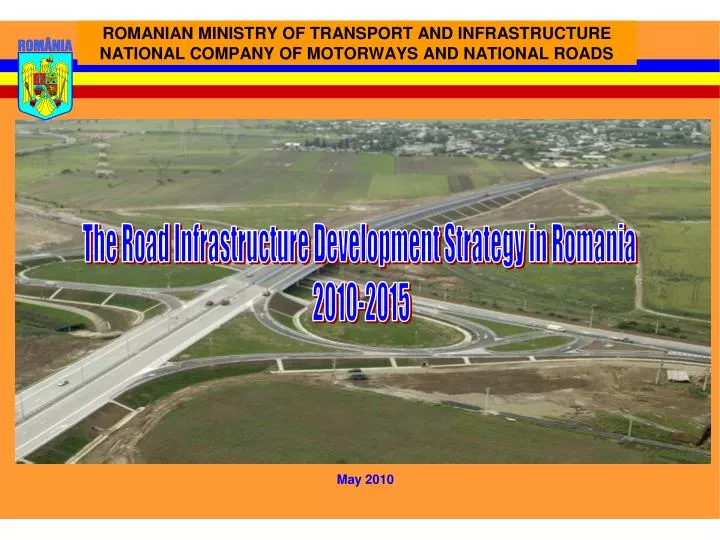
PRESENT STAGE (2010) OF NATIONAL MOTORWAY. SUPLACU DE BARCAU. IASI. BORS. PIATRA NEAMT. MIHAILESTI. ALBITA. BICAZ. GILAU. CAMPIA TURZII. TARGU MURES. SOVATA. GHEORGHIENI. BACAU. PRAID. NADLAC. ARAD. SEBES. SIBIU. DEVA. ORASTIE. FOCSANI. TIMISOARA. BRASOV. LUGOJ.

E N D
PRESENT STAGE (2010) OF NATIONAL MOTORWAY SUPLACU DE BARCAU IASI BORS PIATRA NEAMT MIHAILESTI ALBITA BICAZ GILAU CAMPIA TURZII TARGU MURES SOVATA GHEORGHIENI BACAU PRAID NADLAC ARAD SEBES SIBIU DEVA ORASTIE FOCSANI TIMISOARA BRASOV LUGOJ CRISTIAN GHIMBAV PREDEAL COMARNIC BUZAU U.M=km PLOIESTI PITESTI DRAJNA FETESTI CERNAVODA Bucharest CONSTANTZA
PAN - EUROPEAN CORRIDORS OF ROAD TRANSPORT Corridor no. IV L=3,258 km BERLIN DRESDA NUREMBERG PRAGUE BRNO VIENNA BRATISLAVA GYOR BUDAPEST ARAD CRAIOVA BUCHAREST CONSTANTZA SOFIA PLOVDIV SALONIC ORMENIO ISTANBUL Corridor no. IX L=6,500 km HELSHINKI SAINT PETERSBURG MOSCOW KALINGRAD KIEV ODESA CHISINAU BUCHAREST VILNIUS KRAIPEDO MINSK ALEXAN-DROPOLIS DIMITROGRAV ORMENIO
PAN - EUROPEAN CORRIDOR NO. IV NADLAC Corridor no. IV- Priority Axis no. 7 Coridor no. IV- Southern branch CONSTANTA
Priority Axis no. 7 according to Government Decision 884/2004 Nadlac - Arad Execution 2010 - 2012 Timisoara-Lugoj execution 2010-2012 Orastie-Sibiu execution 2010-2012 By-pass Sibiu execution 2008 - 2010 By-pass Pitesti execution 2004 - 2008 Arad-Timisoara execution 2009-2011 By-pass Bucharest North execution 2011 - 2014 Lugoj-Deva execution 2010-2012 Cernavoda - Constantza execution 2009-2011 Deva-Orastie execution 2010-2012 Drajna - Fetesti execution 2004-2007 Sibiu - Pitesti execution 2011-2014 Bucharest - Drajna execution 2001-2004 Pitesti - Bucharest Fetesti-Cernavoda execution 2004-2006 By-pass Constantza execution 2008 - 2011
DISTANCE KM MilEUR FINANCING execution NADLAC - ARAD 38.88 306.75 COHESION FUND+Gov 2010 - 2012 ARAD - TIMISOARA 44.50 293.26 EIB +Gov 2009 - 2012 TIMISOARA - LUGOJ 35.63 359.00 EIB +Gov 2010 - 2012 LUGOJ - DEVA 99.50 1219.00 ISPA+Gov 2010 - 2012 DEVA - ORASTIE 32.80 253.37 ISPA+Gov 2010 - 2012 ORASTIE - SIBIU 82.07 823.88 COHESION FUND+Gov 2010 - 2012 VARIANTA SIBIU 17.56 81.87 ISPA+Gov 2008 - 2010 SIBIU - PITESTI 116.64 3246.00 CONCESSION 2011 -2014 BY-PASS PITESTI 15.20 113.58 EBRD+Gov 2004 - 2008 PITESTI-BUCHAREST 96.00 45.00 Gov 2005 -2006 BY-PASS BUCHAREST NORTH 52.77 968.00 CONCESSION 2011 - 2014 BUCHAREST - DRAJNA 97.30 320.00 EIB +Gov 2001 - 2004 DRAJNA - FETESTI 36.80 64.60 ISPA+Gov 2004 - 2007 FETESTI-CERNAVODA 17.58 30.22 ISPA+Gov 2004-2006 CERNAVODA - CONSTANTZA 50.75 397.00 EIB+CF +Gov 2009 - 2011 BY-PASS CONSTANTZA 22.10 140.81 EBRD+Gov 2008 - 2011 TOTAL 856.08 8662.34 PAN - EUROPEAN CORRIDOR NO. IV Length = 856.08 KM of motorway
PAN-EUROPEAN CORRIDOR no.IX Focsani-Albita execution 2012 - 2015 Ploiesti-Focsani execution 2011-2014 Bucharest-Ploiesti execution 2007-2010 By-pass Bucharest South execution 2011-2014 Length – 460 km Bucharest-Giurgiu Road with 4 lanes
PAN - EUROPEAN CORRIDOR NO. IX L= 433 KM MOTORWAY
MOTORWAYS AND BY-PASSES CONSTRUCTION WITHEIB / EBRD FINANCING Cernavoda - Constantza Length: 73.15 km Value: 536.54 Mil. Euro By-pass Constantza
CONSTRUCTION OF MOTORWAYS AND BY-PASSES AT MOTORWAY PROFILE CONCESSION PROJECTS Tg Mures-Iasi-Ungheni Focsani-Albita Sibiu - Pitesti Ploiesti-Brasov Ploiesti-Buzau-Focsani By-pass Bucharest North Length: 918.827 km Value:14.836 Mil. Euro By-pass Bucharest South
CONSTRUCTION OF MOTORWAYS AND BY-PASSES AT MOTORWAY PROFILE WITH FUNDING FROM THE EUROPEAN UNION AND THE STATE BUDGET Nadlac - Arad Orastie-Sibiu si by-pass Sebes Timisoara-Lugoj Lugoj-Deva Deva-Orastie Length: 333.38 km Value: 3255.58 Mil. Euro
MOTORWAYS IN EXECUTION WITH FINANCING FROM THE STATE BUDGET BRASOV – BORS Section Suplacu de Barcau - Bors Suplacu de Barcau BRASOV – BORS Section Campia Turzii - Gilau GILAU BUCHAREST – PLOIESTI Section Moara Vlasiei - Ploiesti BUCHAREST – PLOIESTI Section Bucharest – Moara Vlasiei Length: 178.5 km Value : 4.324 Mil.Lei
Bucharest Ring at motorway profile Bucharest Motorway Bypass, km 0+000 – km 100+900 – North bypass sector km 0+000 – km 52+770 Lenght: 52,77 km Platform width: 26 m Road junctions: 7 Passages, bridges,viaducts: 38 Execution duration: 36 months Estimated value: 968 Million Euro Bucharest Motorway Bypass, km 0+000 – km 100+900 – South bypass sector km 52+770 – km 100+765 Lenght :47,995 km Platform width: 26 m Road junctions: 3 Passages, bridges, viaducts: 36 Execution duration: 36 months Estimated value: 901 Million Euro
SIBIU – PITESTI MOTORWAY • Project details: • Length: 116,640 km • Total value: 3246 mil. Euro • Sibiu – Piteşti Motorway is part of Pan-European Corridor no. IV, • which crosses Romania from west to east : • Nădlac - Arad - Timişoara - Lugoj - Deva -Sibiu - Piteşti – • Bucureşti - Constanţa. • Includes works of art with a total length (bridges, passages, viaduct) of 33,788 m / 140 pieces, out of which:- bridges, passages, viaduct on motorway: 31.194 m; • passages over the motorway: 432 m; • - passages over road junctions: 2152 m.
CONSTANTA PORTPIER III S • Investment name: PIER III S • Specialized terminal - value of 80 million Euro • Duration of implementation is four years Advantages: It is placed in the southern part of Constanta, where the deep water allows the high capacity ships to land safely, without technical problems. Feasibility Study was already realized and the current necessary investment needs are already defined.
CONSTANTA PORTPIER III S • PIER III S is placed in the Southern Part of Constanta Port. • This area can be developed more than the Northern Part, from the infrastructure and supra structure point of view, the main particularity of this area is represented by the depth of the seawater, which allows to the high capacity ships to land. • In order to realize a special terminal in the area of PIER 3 S, it is necessary to finalize the infrastructure works, which consist, mainly, in creating the territories by performing material from the excavations fillings Danube - Black Sea, the material deposited on its banks. It is also necessary to carry out infrastructure works such as roads, railway connections and utility networks. • Completion of Pier 3 S quays rise to six berths of November, where large vessels can operate. Completion of associated territories behind these berths would be conducive to a land area of approx. 23 hectares which could be rented to achieve a specialized terminal (ex.Terminal container). • To this area, it can added another one of about 14 ha, located at Pier 3S root, if there are executed the dam filling up the South. From this area, about 11 hectares will be provided for rent with 23 ha and the remaining 3 ha adjacent to South Pier are needed to develop the rail system. • SC IPTANA SA Bucharest developed in 2006 the Feasibility Study dealing with infrastructure works needed to complete the related front landing Pier III Pier S and III S territories filling necessary to dam the South. • Work performed so far consist only of mooring quays, remaining in various stages of completion. • Investing involves carrying landing quays and expanding existing ones and making fillings and moving into the territory of Pier III S over an area of approx. 35 ha. • Feasibility study prepared by SC IPTANA SA Bucharest in 2006 estimated the necessary infrastructure work to be done to develop a specialized terminal value of 80 million, and duration of implementation is four years. The amount required depends on the superstructure construction works the destination that will give the mole. • In 2008, there was approved CTE-MT survey in support of their decision for realizing of works concession. In December 2008 an auction was held to award the concession contract for construction works. The auction was canceled because no offer was made. • Beneficiary : National Company of Maritime Ports Administration SA Constanta
Water Channel Danube – Bucharest Total length of the channel - 73 km 2009 – 2010 (September) – Upgrading the Feasibility Study ongoing; - technical expertise of the hydro-technical works done until 1990 Estimated value for works execution: 1.000 MEURO Beneficiary:Ministry of Transport and Infrastructure National Company of Water Channels SA Constanţa
Benefits The main objectives of complex setting of Arges River are:- linking Bucharest with a waterway by the Danube River, which is a great alternative economically favorable to the transportation by rail and road infrastructure; - Protection against flooding of 11 villages and some agricultural areas totaling 30,000 hectares; - Electricity production, create conditions for recreation and tourism, providing favorable environmental influences and more; - To provide irrigation water for more than 150 000 ha, water supply for neighboring towns and realizing an area of 1250 hectares for fish farming.
Water Channel Danube – Bucharest • The main objectives of complex setting of Arges River were :- linking Bucharest with a waterway by the Danube River, which is a great alternative economically favorable to the transportation by rail and road transport; - Protection against flooding of 11 villages and some agricultural areas totaling 30,000 hectares; - Electricity production, create conditions for recreation and tourism, providing favorable environmental influences and more; - To provide irrigation water for more than 150 000 ha, water supply for neighboring towns and realizing an area of 1250 hectares for fish farming. • Channel has a total length of 73 km, 4 sealing steps to take the 52 m level difference between the Danube Riever and the water in Bucharest Port and was designed for a convoy consisting of a barge having the capacity of 2000 tones and pusher related. • Work on this objective was started in 1986 and interrupted in January 1990. Execution status of the works was advanced in 1990, but abandoned work led to their degradation. • On May 19th, 2008 was published the Government Decision no. 487/2008 regarding the transmission of objective “ Arrangement of Arges River to protect against floods, irrigation and other use "and public property of the state from administration Ministry of Environment and Sustainable Development - National Administration " Romanian Waters " in the administration of the Ministry of Transport, by Navigable Canals Administration National Company SA Constanta to make a waterway from Bucharest to the Danube. • In 2009 were allocated from state budget 1500 lei (0.4 Mil Euro) for updating the feasibility study and an expertise of hydro-technical constructions made until 1990. The contract was signed in September 2009 with the completion term September 2010. In 2010 were allocated from state budget 5500 thousand lei. • Estimated value of work: 1.000 million euros (without funding source). It is proposed that the implementation of works will be done by concession. • Benneficiary: NC Navigable Channels Administration SA Constantza
Thank you for the attention! • Dana Galben General Manager of the General Directorate of Road Infrastructure and Concessions dgiac1@mt.ro • Cristina Amarazeanu National Company of Motorways and National Roads Manager of Planning and Strategy Office cristina.amarazeanu@andnet.ro